- Komárom county
Infobox Former Subdivision
native_name = Comitatus Comaromiensis
conventional_long_name = Komárom County
common_name = Komárom
subdivision = County
nation = theKingdom of Hungary
p1 =
s1 =
year_start = 11th century
event_end = Treaty of Trianon
year_end = 1920
date_end = June 4
capital = Komárom
stat_area1 = 2834
stat_pop1 = 201800
stat_year1 = 1910
today =Slovakia ,Hungary
footnotes =Komárno is the current name of the capital.Komárom county (in Latin: "comitatus Comaromiensis", in Hungarian: "Komárom (vár)megye", in Slovak: "Komárňanský komitát / Komárňanská stolica / Komárňanská župa", in German: "Komorner Gespanschaft / Komitat Komorn") was a historic administrative county (
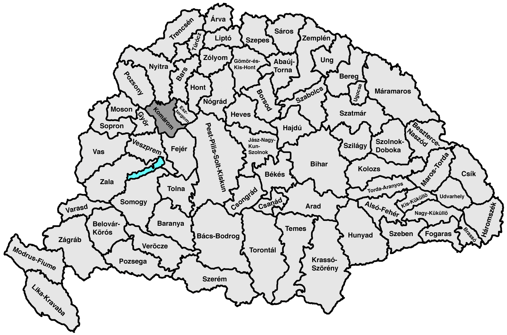
comitatus ) of theKingdom of Hungary in present-day southernSlovakia (1/2) and north-westernHungary (1/2) on both sides of theDanube river.Geography
Komárom county shared borders with the counties Győr, Pozsony (Bratislava), Nyitra (Nitra), Bars (Tekov), Esztergom,
Pest-Pilis-Solt-Kiskun ,Fejér and Veszprém. The riversDanube ,Váh and Nitra run through the county. It also covered the eastern part of the island between the Danube and theLittle Danube (Žitný ostrov , translates as "rye island", "Csallóköz" in Hungarian). Its area was 2834 km² around 1910.Capitals
The capital of the county was the Komárom/
Komárno Castle and later the town of Komárom/Komárno (divided betweenHungary andSlovakia ).History
The Komárom comitatus arose in the 11th century as one of the first comitatus of the
Kingdom of Hungary . It was situated within a radius of about 20 km around Komárom/Komárno .In the aftermath of
World War I , the part of Komárom county north of theDanube became part of newly formed Czechoslovakia (asKomárno county ), as recognized by the concerned states in the 1920Treaty of Trianon . In 1922, the territory of Komárno county was divided between theNitra county and theBratislava county . The part south of the Danube stayed inHungary and merged with the southern part ofEsztergom county to formKomárom-Esztergom county.Following the provisions of the controversial
First Vienna Award , the Czechoslovak part came under Hungarian control in November 1938. A new Komárom county was recreated, which included, besides the territory of pre-1918 Komárom county, most of the Rye Island (Žitný ostrov). After World War II, the pre-war situation was reestablished, except that the name of the Hungarian part became Komárom county again. This county was renamed toKomárom-Esztergom county in 1992. The part of the pre-1918 county north of the riverDanube is now inSlovakia , is part of theNitra region and is largely identical with the Komárno district.ubdivisions
In the early 20th century, the subdivisions of Komárom county were:
Komárno (except the southern part, presentKomárom ),Zemianska Olča ,Dvory nad Žitavou andHurbanovo are presently inSlovakia .
Wikimedia Foundation. 2010.