- Northfleet
-
For the ship wrecked on January 22, 1873, see Northfleet (ship).
Coordinates: 51°26′51″N 0°19′29″E / 51.447588°N 0.324783°E
Northfleet 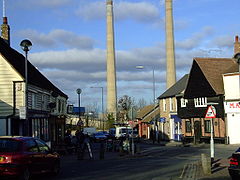
Northfleet High Street dominated by the now-demolished cement plant chimneys.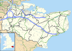
 Northfleet
Northfleet shown within KentPopulation 13,300 (2005)[1] OS grid reference TQ6274 District Gravesham Shire county Kent Region South East Country England Sovereign state United Kingdom Post town Gravesend Postcode district DA11 Dialling code 01474 Police Kent Fire Kent Ambulance South East Coast EU Parliament South East England UK Parliament Gravesham List of places: UK • England • Kent  Looking up Northfleet Hope from The Shore.
Northfleet is a town in the Borough of Gravesham in Kent, England. Its name is derived from North creek (or inlet), and the settlement on the shore of the River Thames adjacent to Gravesend was known as Norfluet in the Domesday Book, and Northflet in 1201. By 1610 the name of Northfleet had become established.
Contents
History
Rosherville Gardens
Further information: Rosherville GardensIn 1815 the first steamboat started plying between Gravesend and London: an event which was to bring much prosperity to the area. The number of visitors steadily increased, and in the course of the next ten years several new and rival steam packets were started.. With the regular service given by the steam packets, amenities for the entertainment of visitors began to spring up. One of those amenities was Rosherville Gardens.
The gardens were laid out in 1837 by George Jones in one of the disused chalk pits, covering an area of 17 acres (69,000 m²). Their full title was the 'Kent Zoological and Botanical Gardens Institution’. They occupied an area in what was to become Rosherville New Town (see below).
Robert Hiscock, in his A History of Gravesend (Phillimore, 1976) describes them thus:
They were a place of surpassing beauty and a favourite resort of Londoners. Adorned with small Greek temples and statuary set in the cliffs, there were terraces, and archery lawn, Bijou theatre, and Baronial Hall for refreshments, and at one time a lake. At night the gardens were illuminated with thousands of coloured lights and there were fireworks displays and dancing. Famous bands such as the American Sousa were engaged during the season. Blondin, the trapeze artist, performed … In 1857 as many as 20,000 visitors passed through the turnstiles in one week. By 1880 the gardens had reached the peak of their popularity … in 1901 they were closed. During a brief revival 1903-1911, they were used in the making of early films.
A pier was built to carry these crowds ashore, and a railway station opened on the Gravesend West branch railway. It was one of the steamboats from Rosherville Gardens that was involved in a horrific accident in 1878. The Princess Alice passenger steamer, after leaving Rosherville pier, was in a collision with the collier Bywell Castle, from Woolwich. 640 people died from the collision, 240 being children. An inquest was held at Woolwich, but no conclusive reason was ever established as to the cause of the disaster at the Devils Elbow on the Thames.
Rosherville New Town
 New builds in Rosherville in 2008
Joseph Rosher gave his name to a building scheme which began with the building of new houses in 1830. A prospectus states that ‘ this spot will ultimate become to Gravesend what St Leonards is to Hastings and Broadstairs to Margate’. That grandiose scheme did not materialise in quite that way, but the area of Northfleet still bears that name.
Northfleet during the Second World War
On Friday, 16 August 1941 150 German aircraft flew through the Kent skies, to deal the worst blow to civilian life the county had experienced to that point in the war. With the formation splitting into groups to be variously challenged from Manston, Kenley, Hornchurch, Biggin Hill and Hawkinge airfields, a group of Dorniers made it to Northfleet a little after midday.
It was reported that about 106 high explosive bombs ranging from 50-250 kilos were dropped over the town and its industrial complex. A total of 29 people were killed, and 27 injured with two schools badly damaged.
Governance
Northfleet Urban District Council was set up under the Local Government Act of 1894. Within its boundaries were the hamlets of Northfleet Green and Nash Street, as well as the now built-up Perry Street; and the later estates at Shears Green, Istead Rise and Downs Road. Northfleet was merged, inter alia, with Gravesend to become Gravesham District Council on 1 April 1974.
Industry and commerce
 Cement works on the Thames estuary
With its situation on a busy waterway such as the River Thames, at a point where higher land came close to the river, it was an obvious place for industry to be located. The river provided water supplies and the means whereby raw materials and products could be transported. The forests of the area provided timber for various aspects of most industries.
Cement
 On the quay at Aspdin´s in Dec 2008
The Romans first began to dig chalk from the area, but the making of cement came later. The industry requires plentiful water supplies, and chalk as its main ingredient, both of which were to hand. When in 1796, James Parker set up kilns on Northfleet creek to make his Roman cement, it was the beginning of a large complex of cement works along this stretch of the river.[2] The manufacture of Portland cement began in April 1846 when William Aspdin, son of Joseph Aspdin, its inventor, acquired Parker's works and built new kilns.
Aspdin's works became Robins & Co in 1853, sold on to the Associated Portland Cement Manufacturers (APCM) in 1900, which was taken over by the Lafarge Group in 2001. By 1900, there were nine cement works operating on the Thames between Swanscombe and Gravesend. The last remaining cement plant in Northfleet will cease operation by end of 2008.
Paper
Northfleet is the location of a large Bowaters (later Bowater-Scott and Kimberly-Clark) paper mill built in 1923 and makes all of the main - line Andrex toilet tissue.[3]
Northfleet Dockyard
Northfleet was by 1800 the home of numerous shipyards which had produced many fine vessels, but the docks were in decline by 1843. One such yard was owned by Thomas Pitcher, a shipwright, laid out in 1788. A list of merchant vessels built at his yard included at least 25 ships for the East Indies and West Indies services, and about the same number for the Navy. In 1839 the company was in the hands of Pitcher's sons William and Henry. The yard finally closed in 1860. There is a fine model of such a ship in St. Botolph's Church
Cable works
 Henley´s
Another large employee of labour in Northfleet was the cable works. Originally Henley's, now AEI, they occupied the land originally once used by the Rosherville Gardens.
AEI Cables closed in 2005 and Henley moved in 2006. The Henley works as of 2010 is completely demolished, and currently an entirely empty site.
Transport
Channel Tunnel Rail Link (CTRL) construction
With the opening in 2003 of the first section of the CTRL which, in part, utilised a long-closed branch railway between Longfield and Gravesend West stations, Section Two was begun. It leaves the first section at Pepper Hill and immediately turns north-westwards; passing under the River Thames downstream of the existing Dartford crossings & heading towards St Pancras station in north London where a new terminus has been built. There is an intermediate station at Stratford, east London. Another new station, Ebbsfleet International railway station, in the Ebbsfleet Valley near Northfleet, has been built. This also is being served by domestic trains running to or from Gravesend, Ashford or towns in east Kent. Eurostar began running over the more direct line in 2007, from which date they ceased to serve Waterloo Station.
However, a design flaw that exists in Ebbsfleet International Station is its lack of pedestrian connections to Northfleet, with both of the shortest routes being inordinately long and less than optimal. Northfleet's local station and Ebbsfleet International Station's domestic passenger entrance are only 250m or so apart, but the walk is disproportionately long, hindering the advantage of living in Northfleet over say nearby Gravesend, which is served by the high-speed service [1][2].
Northfleet churches
 St Botolph´s
The ancient parish church of Northfleet(dating from the 14th century, but with work from earlier periods) is dedicated to St Botolph. Its tower was built in 1717, after the original had fallen. The church contains a C14th carved oak screen, which is thought to be the oldest in Kent. Rosherville St Mark's Church is now part of the Team ministry with St. Botolph's church. The other active church in Northfleet is All Saints, Perry Street which is Anglo Catholic. All Saints Perry Street is the largest Anglican parish in Gravesham Borough with a quarter of the Gravesham population living within its boundaries.
 The Roman Catholic Church
The Roman Catholic church, designed by Giles Gilbert Scott and with its tower foreshadowing his Liverpool Cathedral, is built entirely of brown brick. It was constructed in 1914.
There a United Reformed Church(URC) on Dover Road in Northfleet. The Dover Road Chapel was opened on Wednesday the 20th of June 1850 as a Congregational Church. Northfleet URC is grouped with three other churches in the North Kent URC group. These are St Paul's URC, Singlewell Road, Gravesend; Hartley URC and Southfleet URC.
Culture and community
Rotary Club in Northfleet
The Rotary Club of Northfleet was founded in 1954 and chartered as the Rotary Club of Northfleet - Club No 793 in R.I.B.I. District 1120. The club originally had members from many local industries (cement, engineering, paper making etc.), but as these industries declined along the river front, so membership changed. The club used to meet at lunchtime for many years, but this changed to evening meetings a few years ago. Northfleet Rotary Club, like most Rotary clubs also voted to accept women into Rotary membership, which is by invitation. The club's name was changed in 2005 to Northfleet with Ebbsfleet Rotary Club, to reflect the emerging growth of nearby Ebbsfleet area, with its developing infrastructure of Bluewater shopping complex, new High Speed Rail terminal at Ebbsfleet Station, and commercial and residential properties being developed as part of the wider development the Thames Gateway project.
Sports
Ebbsfleet United Football Club
 The Fleet´s Stadium
Although one would suppose Gravesend to be the main influence in the history of this club, as it was listed first when the towns' clubs merged, it was in fact Northfleet that was to be responsible for the early significant accomplishment of the association football club now known as Ebbsfleet United F.C. Ebbsfleet are currently in the Conference National under manager Liam Daish and his assistant, Paul McCarthy. Star players are Calum Willock and Paul Lorraine
Northfleet Football Academy
Northfleet Football Academy was started in 2009 by local school Northfleet Technology College. Northfleet Football Academy was designed to recruit the elite of Graveshams football players and give them the best possible coaching in order to help them develop as players. The Northfleet Football Academy also offers its participants the opportunity to take a BTEC in Sports and one other additional subject like Science in order to help the players gain nationally recognised qualifications at key stage 4 whilst the players develop their playing skills. The academy is run by Northfleet Technology College teachers Brian Meaney (manager) and Lisa Donaldson (chairman) and also boasts the professional coaching of former Welsh International and current Ashford Town manager Steve Lovell (Welsh footballer) The Academy is based in Northfleet Technology College,Colyer Road, Northfleet. To find out more see Northfleet Football Academy.
Northfleet Urban Country Park
The park sits on the eastern side of Northfleet, on Thames Way opposite the new police station, bounded by Springhead Road & Vale Road. The site is 10.5 hectares and provides a variety of wildlife habitats.
References
- ^ "2005 Ward Level Population Estimates" (PDF). Kent County Council. September 2006. http://www.kent.gov.uk/NR/rdonlyres/E503169D-C06B-498F-BD0A-678EE22B4D37/6841/sae108.pdf. Retrieved 2007-08-20.
- ^ A J Francis, The Cement Industry 1796-1914: a History, David & Charles, 1977, ISBN 0-7153-7386-2
- ^ "Bowater-Scott". Grace's Guide. http://www.gracesguide.co.uk/wiki/Bowater-Scott. Retrieved 2011-02-10.
- ^ http://www.wt-henley.com/contact.html
- Robert H Hiscock, A History of Gravesend, Phillimore, 1976, ISBN 0-85033-242-7
- Frank W Jessup, Kent History Illustrated, Kent County Council, 1966, ISBN 0-900947-06-3
External links
 Media related to Northfleet at Wikimedia Commons
- Details of the Northfleet cement works
- Dartford Archive - includes details of William Aspdin’s work
- Gravesend, Northfleet and Swanscombe Cage Bird Society (Local bird club)
- Rosherville gardens
- All Saints' Church Perry Street
- Shears Green Community Infant School web site
- Northfleet Technology College High school website
- Northfleet with Ebbsfleet Rotary Club (chartered 1954)
- Dover Road Chapel Northfleet URC
Towns and villages in the Borough of Gravesham  Chalk · Cobham · Culverstone Green · Dode · Harvel · Higham · Istead Rise · Luddesdown · Meopham · Meopham Green · Northfleet · Painters Ash · Singlewell or Ifield · Shorne · Sole Street · Springhead · Thong · Vigo
List of places in Kent Ceremonial county of Kent Kent Portal Unitary authorities Boroughs or districts Major settlements Ashford, Broadstairs, Canterbury, Chatham, Cranbrook, Dartford, Deal, Dover, Edenbridge, Faversham, Folkestone, Fordwich, Gillingham, Gravesend, Greenhithe, Herne Bay, Hythe, Lydd, Maidstone, Margate, Minster, New Romney, Northfleet, Paddock Wood, Queenborough, Rainham, Ramsgate, Rochester, Royal Tunbridge Wells, Sandwich, Sevenoaks, Sheerness, Sittingbourne, Snodland, Southborough, Strood, Swanley, Swanscombe, Tenterden, Tonbridge, Walmer, West Malling, Westerham, Westgate-on-Sea, Whitstable
See also: List of civil parishes in KentRivers See: Rivers of KentTopics Categories:- Gravesham
- Towns in Kent
- Port of London


Wikimedia Foundation. 2010.