- Baranof Island
Infobox Islands
name = Baranof
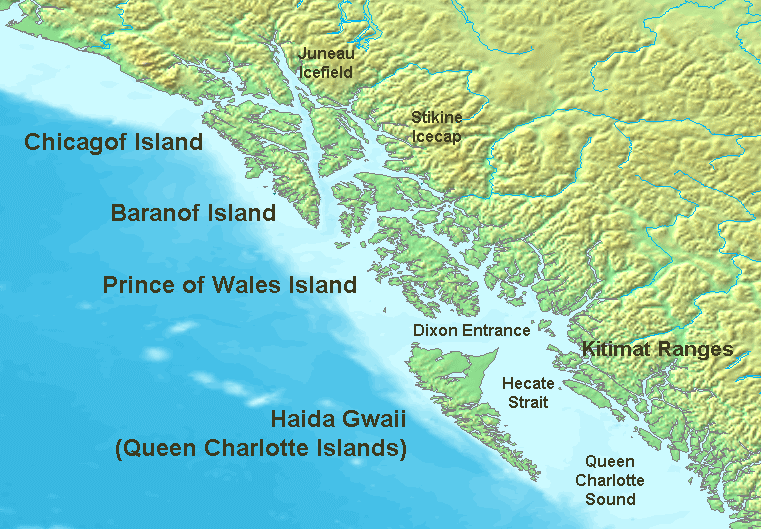
image caption = Islands of the Pacific Northwest Coast
image size =
locator
Location map|Alaska|lat=57.0|long=-135.0
map_custom = yes
native name =
native name link =
nickname =
location = ABC islands of Alaska
coordinates = coord|57|0|N|135|0|W|display=inline
archipelago =Alexander Archipelago
total islands =
major islands =
area = convert|1607|sqmi|km2
length = convert|100|mi|km
width = convert|30|mi|km
highest mount =
elevation =
country = United States
country admin divisions title = State
country admin divisions = flag|Alaska
country admin divisions title 1 =
country admin divisions 1 =
country admin divisions title 2 =
country admin divisions 2 =
country largest city =
country largest city population =
population = 8532
population as of = 2000
density = 2.05
ethnic groups =
additional info =Baranof Island, also sometimes called Baranov Island or Sitka Island, is an
island in the northernAlexander Archipelago in theAlaska Panhandle , inAlaska . It was called "Sheet’-ká X'áat'l" (often expressed simply as "Shee") by the nativeTlingit Clan. It is one of the ABC islands of Alaska.The Island has a land area of 1,607 square
mile s (4,162 squarekilometer s), which is approximately the same as the State ofDelaware , and measures 100 miles (160 kilometers) by 30 miles (48 kilometers) at its longest and widest points respectively. Baranof Island is the most mountainous island in the Alexander Archipelago, the eighth largest island in Alaska, the tenth largest island in the United States, and the 137th largest island in the world. Its center is near coord|57|0|N|135|0|W|. The population of the island was 8,532 at the 2000 census.Almost the entire area of the Island is part of the City and Borough of Sitka (Sitka also extends northward onto
Chichagof Island ); the only part of Baranof that is not in Sitka is a tiny sliver of land (9.75 km²) at the extreme southeast corner, which is in the Wrangell-Petersburg Census Area, and includes the town of Port Alexander. This section had a 2000 census population of 81 persons. The towns ofBaranof Warm Springs ,Port Armstrong , andPort Walter are also located on the eastern side of the island. Goddard, a now-abandoned settlement about 16 miles south of Sitka, features a few private homes and hot springs with two public bathhouses. There are also three year-roundsalmon hatcheries, one located just north of Port Alexander at Port Armstrong, another located just north of Baranof Warm Springs atHidden Falls , the other just south of Sitka nearMedvejie Lake . The latter is accessible by private road from Sitka. All of these communities, except for Port Alexander, are under the jurisdiction of the City and Borough of Sitka, of which, Sitka serves as the borough seat.Fishing, seafood processing, and tourism are important industries on the island, which is also famous for
brown bear s andSitka deer .The first European settlement on island was established in 1799 by
Alexandr Baranov , Chief Manager and first Governor of theRussian-American Company , for whom the Island and Archipelago are named. Baranof Island was the center of Russian activity in North America during the period from 1804–1867 and was the headquarters of the Russian fur-trading interest.Around 1900, Baranof Island was subject to many small-scale
mining ventures, especially centered around Sitka and on the north side of the Island around Rodman Bay. Canneries, whaling stations, and fox farms sprung up on all sides of the Island, though most had been abandoned by the outbreak ofWorld War II . The remains of these outposts are still evident, though most exist in a dilapidated condition.The 1939
Slattery Report on Alaskan development identified the island as one of the areas where new settlements would be established throughimmigration . This plan was never implemented.See also
*
List of geographic features on Baranof Island External links
* [http://www.sitkatribe.org/placenames/home.html Tlingit Geographical Place Names for the Sheet’Ka Kwaan — Sitka Tribe of Alaska] , an interactive map of Sitka Area native place names.
Wikimedia Foundation. 2010.