McDowell Mountains

McDowell Mountains
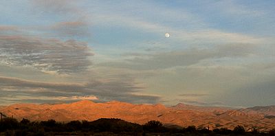
Sunset in the foothills of the McDowell Mountains

The McDowell Mountain Range (Yavapai: Wii Kajessa) is located about twenty miles north-east of Phoenix, Arizona, and may be seen from most places throughout the city. The range is composed of miocene deposits left nearly five million years ago. The McDowells share borders with the cities of Fountain Hills, Scottsdale, and Maricopa County. The city of Scottsdale has made its share of the McDowells a preserve, and has set up a wide trail network. The highest peak in the McDowells is East End Peak, at four thousand two hundred feet. This mountain range also serves as a sacred marker to the Yavapai people. The boundaries of the range are generally defined by Saddleback Mountain in the South and Granite Mountain as the Northern boundary. The McDowells also comprise popular landmarks such as Pinnacle Peak and Tom's Thumb. Although technically a stand alone, Mt. McDowell (referred to as Red Mountain by Phoenix residents), not to be confused with McDowell Peak, is sometimes listed on maps as a part of the McDowell Mountains.

Summits

  • East End Peak
  • Thompson Peak (Arizona)
  • McDowell Peak
  • Sunrise Peak
  • Rock Knob

References

  • Thompson, C. (2004), Valley 101.

External links


Coordinates: 33°39′43″N 111°48′44″W / 33.6619868°N 111.8120865°W / 33.6619868; -111.8120865


Wikimedia Foundation. 2010.

Игры ⚽ Нужна курсовая?

Look at other dictionaries:

  • McDowell Peak — is located in the McDowell Mountains, to the northeast of Phoenix, Arizona. Its height is almost 4000 feet. McDowell Peak is located approximately half a mile north of the easily recognizable Thompson Peak (Arizona), and shares a ridge with the… …   Wikipedia

  • McDowell County, West Virginia — McDowell County Courthouse in Welch, West Virginia …   Wikipedia

  • McDowell County, North Carolina — McDowell County Courthouse in Marion …   Wikipedia

  • Mount McDowell — Red Mountain, FireRock Red Mountain from Fountain Hills, Arizona …   Wikipedia

  • Gefecht bei McDowell — Jacksons Shenandoah Feldzug umfasste eine Reihe von Schlachten und Gefechten im westlichen Virginia während des Amerikanischen Bürgerkriegs im Frühjahr 1862. Innerhalb von drei Monaten marschierten 17.000 Soldaten der Konföderation unter… …   Deutsch Wikipedia

  • Schlacht bei McDowell — Jacksons Shenandoah Feldzug umfasste eine Reihe von Schlachten und Gefechten im westlichen Virginia während des Amerikanischen Bürgerkriegs im Frühjahr 1862. Innerhalb von drei Monaten marschierten 17.000 Soldaten der Konföderation unter… …   Deutsch Wikipedia

  • Charles T. McDowell — Charles Taylor McDowell Born November 23, 1921(1921 11 23) Twin Falls, Idaho Died July 8, 2007(2007 07 08) (aged 85) Arlington, TX Occupation Professor of Russian, Military Officer …   Wikipedia

  • National Register of Historic Places listings in McDowell County, West Virginia — Location of McDowell County in West Virginia This is a list of the National Register of Historic Places listings in McDowell County, West Virginia. This is intended to be a complete list of the properties and districts on the National Register of …   Wikipedia

  • Cumberland Mountains — Range View of Cross Mountain in Tennessee …   Wikipedia

  • Bradshaw, McDowell County, West Virginia — Bradshaw is a town in McDowell County, West Virginia, United States. The population was 289 at the 2000 census. Bradshaw was incorporated in December 1979 and is named for a man who settled at the mouth of Bradshaw Creek in about 1840. His… …   Wikipedia

Share the article and excerpts

Direct link
Do a right-click on the link above
and select “Copy Link”