- Charentsavan
-
Coordinates: 40°24′35″N 44°38′35″E / 40.40972°N 44.64306°E
Charentsavan
ՉարենցավանView of Charentsavan at dusk
 Charentsavan
Coordinates: 40°24′35″N 44°38′35″E / 40.40972°N 44.64306°E Country Armenia Marz (Province) Kotayk Established 1948 Area – Total 5 km2 (1.9 sq mi) Population (2008) – Total 17,752 Time zone UTC (UTC+4) – Summer (DST) DST (UTC+5) Charentsavan (Armenian: Չարենցավան, also Romanized as Ch’arents’avan, Ch’arants’avan, Čarencavan, and Choentsavan; formerly named Lusavan until 1967) is a city located in the Kotayk Province (marz) of Armenia. Its population of 19,708 people at the 2001 census has since declined. The city was founded in 1948, and renamed in 1967 in honor of the poet Yeghishe Charents.[1]
Sport
References
- ^ Kiesling, Rediscoving Armenia, p. 56, available online at the US embassy to Armenia's website
- Charentsavan at GEOnet Names Server
- World Gazeteer: Armenia – World-Gazetteer.com
- Report of the results of the 2001 Armenian Census, National Statistical Service of the Republic of Armenia
Capital: HrazdanHrazdan Aghavnadzor · Artavaz · Hankavan · Hrazdan · Jrarat · Kaghsi · Lernanist · Marmarik · Meghradzor · Solak · Tsaghkadzor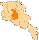
Abovyan Abovyan · Akunk · Aramus · Arinj · Arzni · Balahovit · Byureghavan · Dzoraghbyur · Garni · Geghadir · Geghard · Geghashen · Goght · Hatis · Hatsavan · Jraber · Jrvezh · Kamaris · Kaputan · Katnaghbyur · Kotayk · Mayakovski · Nor Gyugh · Nurnus · Ptghni · Radiokayanin kits · Sevaberd · Verin Ptghni · Voghjaberd · Zar · Zovashen · ZovkYeghvard Charentsavan Categories:- Populated places in Kotayk
- Cities and towns built in the Soviet Union
- Populated places established in 1948
- Kotayk geography stubs


Wikimedia Foundation. 2010.