- Claridon Township, Geauga County, Ohio
-
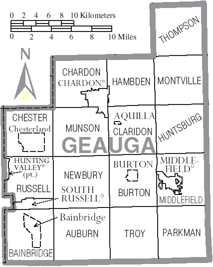
Claridon Township, Geauga County, Ohio — Township — Motto: Land of Steady Habits Municipalities and townships of Geauga County.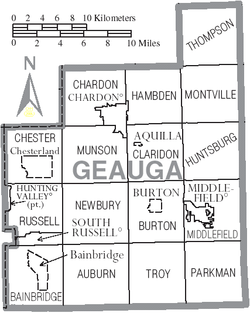
Coordinates: 41°32′8″N 81°9′8″W / 41.53556°N 81.15222°WCoordinates: 41°32′8″N 81°9′8″W / 41.53556°N 81.15222°W Country United States State Ohio County Geauga Area - Total 22.9 sq mi (59.2 km2) - Land 22.7 sq mi (58.8 km2) - Water 0.2 sq mi (0.4 km2) Elevation[1] 1,250 ft (381 m) Population (2000) - Total 3,173 - Density 139.8/sq mi (54.0/km2) Time zone Eastern (EST) (UTC-5) - Summer (DST) EDT (UTC-4) FIPS code 39-15168[2] GNIS feature ID 1086152[1] Claridon Township is one of the sixteen townships of Geauga County, Ohio, United States. The 2000 census found 3,173 people in the township, 2,801 of whom lived in the unincorporated portions of the township.[3]
Contents
History
Claridon Township was settled in 1808 by Asa Cowles and Seth Spencer. Claridon was originally named Canton then Burlington when part of Burton. Early settlers relied heavily upon an agriculturally based economy, with included dairying, poultry and potato crops. Several cheese factories were built in the township, including the Hall Cheese Factory constructed in 1863. Other industries were blacksmith shops, carpentry shops, maple sugaring, and Nathaniel Spencer's chair factory (the oldest manufacturing business in the township, built in 1811). A railroad was constructed in 1872, with a line running through eastern and northern sections of Claridon. This aided in shipping butter, eggs, cheese and maple syrup to the other communities. One of the oldest roads in Geauga County, Old State Road (State Route 608), runs diagonally across the eastern part of Claridon. In 1932, the city of Akron started a reservoir project, seeking to supply the city with fresh water. Known as the East Branch Reservoir, it is situated partially within Claridon Township. Munson, once named McDonough was cut out of Claridon, but East Branch Reservoir remains. Claridon was split east and center due to religious differences and the Methodist Church was moved as a result of those differences.[4]
Geography
Located in the north central part of the county, it borders the following townships:
- Hambden Township - north
- Montville Township - northeast corner
- Huntsburg Township - east
- Middlefield Township - southeast corner
- Burton Township - south
- Newbury Township - southwest corner
- Munson Township - west
- Chardon Township - northwest corner
The township covers a total area of 25 sq mi.[citation needed] The Cuyahoga River flows through the township.
The village of Aquilla is located in northwestern Claridon Township, and the unincorporated community of East Claridon lies in the eastern part of the township.
Name
 An average home in Claridon Township.
Statewide, the only other Claridon Township is located in Marion County.
Government
The township is governed by a three-member board of trustees, who are elected in November of odd-numbered years to a four-year term beginning on the following January 1. Two are elected in the year after the presidential election and one is elected in the year before it. There is also an elected township fiscal officer,[5] who serves a four-year term beginning on April 1 of the year after the election, which is held in November of the year before the presidential election. Vacancies in the fiscal officership or on the board of trustees are filled by the remaining trustees.
Public services
Education
 Berkshire High School
Students from the eastern two-thirds of the township attend schools in the Berkshire Local School District in Burton, while students from the western third of the township attend schools in the Chardon Local School District. Both school districts received excellent ratings in the 2006-2007 school year.[citation needed]
Parks
Parks in Claridon Township include Headwaters Park and the Maple Highlands Trail.
Transportation
Claridon Township is traversed by the following Ohio state and U.S. highways:
References
- ^ a b "US Board on Geographic Names". United States Geological Survey. 2007-10-25. http://geonames.usgs.gov. Retrieved 2008-01-31.
- ^ "American FactFinder". United States Census Bureau. http://factfinder.census.gov. Retrieved 2008-01-31.
- ^ Geauga County, Ohio — Population by Places Estimates Ohio State University, 2007. Accessed 15 May 2007.
- ^ Pioneer and General History of Geauga County, 977.1336 PIO dated 1956
- ^ §503.24, §505.01, and §507.01 of the Ohio Revised Code. Accessed 4/30/2009.
External links
Municipalities and communities of Geauga County, Ohio County seat: Chardon City 
Villages Aquilla | Burton | Hunting Valley‡ | Middlefield | South Russell
Townships CDPs Unincorporated
communitiesFootnotes ‡This populated place also has portions in an adjacent county or counties
Categories:- Townships in Geauga County, Ohio


Wikimedia Foundation. 2010.