- Chermside, Queensland
-
Chermside
Brisbane, Queensland
Chermside Shopping CentrePopulation: 6348 (2006) [1] Postcode: 4032 Area: 3.4 km² (1.3 sq mi) Location: 10 km (6 mi) north of Brisbane CBD LGA: City of Brisbane State District: Stafford Federal Division: Lilley Suburbs around Chermside: Aspley Aspley Geebung Chermside West Chermside Wavell Heights Stafford Kedron Wavell Heights Chermside is a suburb on the north side of Brisbane, Queensland, Australia. Chermside is a key destination along Queensland Transport's future Northern Busway. Chermside is home to Queensland's largest shopping centre which contains a 3 story Myer and a 16 screen cinema complex.
Together with Indooroopilly, in the west; Carindale, in the southeast; and Mount Gravatt, on the south side; the suburb has been described as a mini-CBD.
History
The Chermside area was first settled by Europeans in the late 19th century. The first plot of land was sold on 23 May 1866, and the population has progressively increased since with a significant increase with the post-war residential development.
In November 1868 Cobb & Co. stagecoaches began to travel through Chermside on the way to the goldfields at Gympie.
Brisbane's tramway network finally reached the suburb on the 29 March 1947, and Chermside remained the northernmost point on the system until the line to Chermside was closed on 2 December 1968. The tram line along Gympie Road was separated from other traffic (this is commonly called "reserved track"), which resulted in fast travel times along this portion of the route. Another feature of the Chermside tram line were the rose gardens which bordered the reserved track portion of the line. A picture of the Chermside tram line can be viewed at [1].
Originally named Downfall Creek, the suburb's name was change to Chermside in 1903 after the Governor of Queensland, Major-General Sir Herbert Chermside
Chermside State School (then called Downfall Creek State School) was opened on the 9 July 1900 and closed on 13 December 1996 [2]. Craigslea State School opened 24 January 1972 and a neighbouring High School in January 1975.
The Dawn theatre first opened in 1928 (showing The Man Who Laughs), and closed on the 2 August 2005 (with Mr. & Mrs. Smith). It was the last single screen cinema in Brisbane.
 Bus terminal at Drive-In Shopping Centre, Chermside, ca. 1957
Westfield Chermside first opened in May 1957 as The Chermside Drive-in Shopping Centre with an Allan & Stark's department store and a small arcade of a dozen shops, before becoming a Myer department store. It was the first drive-in shopping centre in Australia. It is now the largest single level shopping centre in Australia, with a 4 storey Myer, as well as a 16 screen Birch, Carrol and Coyle megaplex. It is also home to Brisbane's first Apple Store.[2]
The early 1970s saw the opening of Queensland's first Kmart store in Chermside, which was situated next to a Coles supermarket. Both of these stores closed in the mid-1990s and have been replaced with a Woolworths supermarket and specialty stores. Both Kmart and Coles have been relocated in Westfield Chermside.
Chermside has many outdoor recreational facilities, including two large parks, 7th Brigade Park, and Marchant Park - on land donated 9 September 1921 by soft drink manufacturer George Marchant. Before and during World War I this land had been variously the home of artillery and light horse units. During World War II a diverse range of volunteers, soldiers, and camps were at Chermside, such as U.S. Army units, including a number of African American soldiers. A Kitty Hawk plane on a training flight crashed there in 1943, killing the pilot and instructor.
Chermside has had a library since 1909 - it now forms a branch of the Brisbane City Council Library service, and is situated next to the Kedron Wavell RSL and some sports facilities, including a moderate water park. The Prince Charles Hospital (Public) was opened in 1959 and Holy Spirit Northside Private Hospital in 2001.
A history of Chermside was published by a local teacher and part time historian Mr David R Teague in 1973 [3].
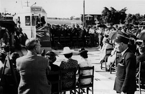 The opening of the Chermside tram line in 1947. The open field behind the tram is the site of the Chermside drive-in shopping centre
References
- ^ Australian Bureau of Statistics (25 October 2007). "Chermside (Brisbane City) (State Suburb)". 2006 Census QuickStats. http://www.censusdata.abs.gov.au/ABSNavigation/prenav/LocationSearch?collection=Census&period=2006&areacode=SSC31135&producttype=QuickStats&breadcrumb=PL&action=401. Retrieved 23 January 2011.
- ^ http://michaelmoren.blog.professionalsaranahills.com.au/2009/12/01/a-visit-to-the-new-apple-store-in-brisbane/
External links
- Chermside and Districts Historical Society
- University of Queensland: Queensland Places: Chermside and Chermside West
- Queensland School opening and closing dates- C
Coordinates: 27°23′00″S 153°01′00″E / 27.3833333°S 153.0166667°E
Categories:- Suburbs of Brisbane


Wikimedia Foundation. 2010.