- Swede Hollow
-
 This sign, posted on Phalen Boulevard near Westminster Junction, describes the history of the Railroad Island and Swede Hollow neighborhoods. The shaded area on the map is Railroad Island; the stream immediately to the right of the shaded area is Swede Hollow.
Swede Hollow was a neighborhood of Saint Paul, Minnesota. It was one of a large group of neighborhoods collectively known as the East Side, lying just to the east of the near-downtown Railroad Island neighborhood, and at the northwestern base of Dayton's Bluff. It was capped in the north by the sprawling Hamm's Brewery (with its imposing Hamm family mansion), and in the south by the historic Seventh Street Improvement Arches. Although one of the oldest settlements in the city, it was also arguably the poorest as each wave of immigrants settled in the valley.[1] Swedes, Poles, Italians and Mexicans all at one point called the valley home. A similar community just downstream called Connemara Patch also existed for Irish immigrants.
Contents
History
Originally the area was a small, steep, wooded ravine cut through by Phalen Creek. The first settler, Edward Phelan, moved there in 1841. Phelan fled Minnesota in 1850 after perjury charges arose but not before being leaving a mark that would change what was once Mill Creek to Phalen.[2][3] Among the earliest inhabitants to settle permanently in the isolated spot were Swedish immigrants. First arriving in the 1850s, they gave their new home the name "Svenska Dalen," a title (or, rather, its English translation) which remained long after the original settlers had moved on, to be replaced by a wave of Italian immigrants in the early twentieth century. At the time of the neighborhood's demise in the mid-fifties, it had attracted a collection of Mexican families as well.
 Swede Hollow in 1910 which was during the later years of Swedish immigration.
Although remembered with a certain sense of nostalgia today, it is not an exaggeration to describe the former area as a true slum. People and industries occupying the surrounding "upper" neighborhoods used the Hollow for an impromptu dump, which the inhabitants down below routinely scavenged for clothing, metals, building supplies, and even shoe repair needs.[4] Several gristmills operated on the creek by the 1850s. In addition railroad tracks were built along the creek in 1865, because the creek bed provided a relatively easy grade up from the Mississippi River compared to the bluffs in other places.[2]
Quite remarkable for a neighborhood in the heart of a major American city of the mid-twentieth century (and even more so considering the challenging climate of the Twin Cities region), Swede Hollow was never electrified, and plumbing conditions were extremely primitive. The residences were constructed almost entirely out of recovered and scrapped building materials, and the entire affair was serviced by a single meandering dirt road. Toilet facilities consisted of outhouses constructed directly over Phalen Creek. The original inhabitants of Swede Hollow got their water from springs and used Phelan Creek as their sewer, leading to water and sanitation problems.[5]
Destruction
So squalid were the conditions of the Hollow, in fact, that in 1956 the entire neighborhood was declared a health hazard by the city. The last remaining families were forcibly evicted, and the entire housing stock was burnt to the ground on December 11 of the same year. At one time (1905) as many as 1,000 people called the tiny little glade their home, although there was much less remaining (14 families in all) at the time of the December 11, 1956 clearing.[2][6]
Today
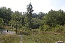
Soon after the destruction the area became a dumping ground and gathering place for the homeless. In the 1970s the valley was cleaned up and was designated a nature center in 1976. A 1917 report remarked, "Phalen Creek and the banks of this stream are ideal for park purposes, while in their present state they constitute a menace to the health of the residents and to the community at large."[6] The area remains uninhabited to this day. The original woodland state has returned (although some of the building foundations still remain), the creek was partially restored, and the entire valley has been made part of Swede Hollow Park, a city park. The trail running along the west edge of Swede Hollow is the Bruce Vento Regional Trail, paved on the former right-of-way of the Northern Pacific Railway's Skally Line that ran from St. Paul to Duluth.[2]
Connemara Patch
 The Seventh Street Improvement Arches separated Swede Hollow from Connemara Patch. The north side (foreground) of the photograph is Swede Hollow; the area partially visible beyond the arches is the former site of Connemara Patch
Just south of Swede Hollow (and downstream of it) was a lesser-known Irish neighborhood called Connemara Patch. It was so named after the original home of the group that was settled there, who arrived in the United States under the sponsorship of Archbishop John Ireland, who settled them on prairie claims near Graceville, Minnesota. When the original rural colonization plan was aborted by the long, blizzard-wracked winter of 1880 (a season so harsh that it was immortalized by the Laura Ingalls Wilder book The Long Winter), the desperate immigrants were resettled along lower Phalen Creek in the area between East Seventh and East Fourth streets as a stopgap measure—one which ultimately became a permanent situation. The legendary Irish language storyteller Éamon a Búrc spent several years in the district before a railroad accident took his leg and caused him to return to his village in County Galway, Ireland.[7][8][9]
Like Swede Hollow, Connemara Patch was eventually cleared of its inhabitants. The remnants of the neighborhood were completely destroyed by urban renewal in the 1950s. Interstate 94 currently occupies a substantial portion of the old enclave. The rest of the site is largely vacant, except for a few dilapidated industrial structures.[6] Coordinates: 44°57′37″N 93°04′34″W / 44.9603°N 93.0760°W[10]
References
- ^ Lost Twin Cities 2: Swede Hollow Twin Cities Public Television
- ^ a b c d Millett, Larry (2007). AIA Guide to the Twin Cities: The Essential Source on the Architecture of Minneapolis and St. Paul. Minnesota Historical Society Press. pp. 385. ISBN 0-87351-540-4.
- ^ Kunz, Virginia Brainard. Saint Paul: The First One Hundred and Fifty Years. Bookmen. pp. 15–16. ISBN 0-9630690-0-4.
- ^ Part I: The Great Depression in Swede Hollow, by Michael T. Sanchelli Minnesota Historical Society
- ^ "Swede Hollow Continues Immigrant Tradition with a Focus on Water". Minnesota Department of Health. 24-Jan-2007. http://www.health.state.mn.us/divs/eh/water/com/waterline/featurestories/swedehollow.html. Retrieved August 28, 2009.
- ^ a b c L. Empson, Donald (2006). The Streets Where You Live. University of Minnesota Press. pp. 60, 262–263. ISBN 0-8166-4729-1.
- ^ Kunz, Virginia Brainard. Saint Paul: The First One Hundred and Fifty Years. Bookmen. pp. 57. ISBN 0-9630690-0-4.
- ^ Regan, Ann (2002). Irish in Minnesota. St. Paul, MN: Minnesota Historical Society Press. pp. 22–23. ISBN 087351419x.
- ^ Binchy, Maeve; O'Donoghue, Jo (2004). Brewer's dictionary of Irish phrase & fable. London: Weidenfeld & Nicholson. pp. 393. ISBN 0-304-36334-0.
- ^ Swede Hollow Park, Duluth, MN. Google Earth. Retrieved 2011-03-14.
Further reading
Categories:- Neighborhoods in Saint Paul, Minnesota
- Irish-American neighborhoods
- Geography of Saint Paul, Minnesota
- Former populated places in Minnesota


Wikimedia Foundation. 2010.