- Charlotte Harbor (estuary)
-
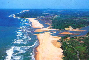
 Estuary mouth
Charlotte Harbor Estuary is a natural estuary spanning the west coast of Florida from Venice to Bonita Springs on the Gulf of Mexico and is one of the most productive wetlands in Florida.[1] The estuary has a large watershed, including the Peace River, Caloosahatchee River (via Pine Island Sound) and Myakka River basins and covering 12,653 square kilometers, the second largest open water estuary in the state.[2][not in citation given] It is classified as a bar-built estuary, formed when sandbars build up along the coastline. The sand bars block the waters behind them from the sea. Such estuaries tend to be shallow with minimal tidal action.[3]
This is a threatened ecosystem because of the rapid increase of growth and development, poor land-use policies, and the overuse of natural resources.[4] The Charlotte Harbor Aquatic Preserves, established by the state of Florida in 1975, are five contiguous aquatic preserves within the greater Charlotte Harbor estuary. It includes salt marshes, mangroves, seagrass, oyster and tidal flats.[5] It is the preserve of many endangered species, including the Florida panther, American Alligator, West Indian Manatee, Bald Eagle, Wood Stork, Piping Plover, American crocodile, Green and Loggerhead Sea Turtles, Gulf sturgeon, Royal False Pawpaw (Deeringothamnus pulchellus), Florida Perforate Cladonia (Cladonia perforata) and many more.[2]
-

Florida seagrass
-

Loggerhead turtle (closeup)
-

Coastal mangroves
-

Florida seagrass bed
Notes
- ^ "Charlotte Harbor Preserve State Park". floridastateparks.org. http://www.floridastateparks.org/charlotteharbor/. Retrieved 2007-01-19.
- ^ a b "Charlotte Harbor". National Estuary Program. United States Environmental Protection Agency. Archived from the original on 2006-10-02. http://web.archive.org/web/20061002063334/http://www.epa.gov/owow/estuaries/programs/ch.htm. Retrieved 2007-01-19.
- ^ "Bar-Built Estuary". Office of Marine Programs. University of Rhode Island. Archived from the original on 2006-09-11. http://web.archive.org/web/20060911133539/http://omp.gso.uri.edu/doee/science/descript/barbuilt.htm. Retrieved 2007-01-21.
- ^ "Charlette Harbor National Estuary Program". http://www.chnep.org/. Retrieved 2007-01-21.
- ^ "The Charlotte Harbor Aquatic Preserves". dep.state.fl.us. http://www.dep.state.fl.us/coastal/sites/charlotte/info.htm. Retrieved 2007-01-19.
See also
External links
- Estuaries Classified by Geologic Features
- Charlotte Harbor Environmental Center
- Map of estuary area
- Charlotte Harbor Watershed - Florida DEP
Coordinates: 26°46′33″N 82°08′31″W / 26.77583°N 82.14194°W
Categories:- Geography of Charlotte County, Florida
- Estuaries of Florida
- Gulf of Mexico
- Landforms of Lee County, Florida
- Florida geography stubs
-


Wikimedia Foundation. 2010.