- New York State Route 12E
-
NYS Route 12E
Route information Auxiliary route of NY 12 Maintained by NYSDOT, Jefferson County and the city of Watertown Length: 39.76 mi[2] (63.99 km) Existed: 1930[1] – present Major junctions South end:  NY 12 in Watertown
North end: NY 12 in ClaytonLocation Counties: Jefferson Highway system Numbered highways in New York
Interstate • U.S. • N.Y. (former) • Reference • County←  NY 12D
NY 12F  →
→New York State Route 12E (NY 12E) is a state highway located entirely within the northwestern part of Jefferson County in northern New York, USA. Officially, the southern terminus of NY 12E is at NY 12 in the city of Watertown; however, its signed terminus is at NY 12F in the village of Brownville. Its northern terminus, both signed and official, is at NY 12 in the village of Clayton. NY 12E diverges westward and then eastward to follow the shoreline of Lake Ontario, unlike NY 12, which follows a direct north–south routing between Watertown and Clayton. The portion of NY 12E north of its junction with NY 180 is part of the Seaway Trail, a National Scenic Byway.
Contents
History
In 1924, NY 3 was assigned to the New York portion of the Theodore Roosevelt International Highway, an auto trail that extended from Portland, Maine, to Portland, Oregon. In New York, it connected North Tonawanda (near Niagara Falls) in the west to Plattsburgh in the east via Rochester and Watertown.[3] In Jefferson County, the trail and NY 3 entered Watertown on modern U.S. Route 11 and exited on what is now NY 12F. At Dexter, NY 3 turned north to follow current NY 180 and NY 12E to Clayton, where it continued eastward on modern NY 12.[4][5]
In the 1930 renumbering of state highways in New York, NY 3 was rerouted to exit Watertown to the east on its modern alignment. The former alignment of NY 3 from Watertown to Clayton was redesignated as NY 12E.[1] At the same time, an alternate route of NY 12E extending from the modern junction of NY 12E and NY 180 to downtown Watertown along the northern bank of the Black River was designated as NY 12F.[6] The alignments of NY 12E and NY 12F east of what is now NY 180 were swapped ca. 1939, placing both routes on their current alignments.[7][8]
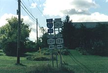 The signed southern terminus of NY 12E
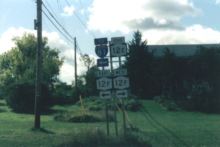
On August 1, 1979, maintenance of NY 12E between Bridge Street in Brownville and the Watertown city line was transferred from the state of New York to Jefferson County as part of a larger highway maintenance swap between the two levels of government. In return, the state assumed maintenance of Bridge Street in Brownsville and the town of Hounsfield, among other highways.[9] Following the swap, the segment of NY 12E between Bridge Street and the Watertown city limits became concurrent with County Route 190[10][11] while Bridge Street became NY 971H, an unsigned reference route.[12]
Current signage along NY 12E indicates that the route has been rerouted east of Bridge Street to follow NY 971H across the Black River to a terminus at NY 12F.[13] However, the 2009 New York State Department of Transportation (NYSDOT) description of routes in New York and the 2008 NYSDOT Traffic Data Report both indicate that NY 12E's southern terminus is still located at NY 12 in downtown Watertown.[2][12]
Major intersections
The entire route is in Jefferson County.
Location Mile[2] Destinations Notes Watertown 0.00 NY 12Village of Brownville 3.79 Bridge Street (NY 971H) To NY 12F Town of Brownville 7.78  NY 180
Chaumont 13.03  CR 179
Former southern terminus of NY 179 Village of Cape Vincent Point Street To Wolfe Island (former Hwy 95) via ferry Village of Clayton 39.76 NY 121.000 mi = 1.609 km; 1.000 km = 0.621 mi References
- ^ a b Dickinson, Leon A. (January 12, 1930). "New Signs for State Highways". The New York Times: p. 136.
- ^ a b c "2008 Traffic Volume Report for New York State" (PDF). New York State Department of Transportation. June 16, 2009. pp. 42–43. https://www.nysdot.gov/divisions/engineering/technical-services/hds-respository/NYSDOT%20TVR%202008%20by%20Route.pdf. Retrieved January 30, 2010.
- ^ "New York's Main Highways Designated by Numbers". The New York Times: p. XX9. December 21, 1924.
- ^ Rand McNally (1926). Rand McNally Auto Road Atlas (western New York) (Map). http://www.broermapsonline.org/members/NorthAmerica/UnitedStates/Midatlantic/NewYork/unitedstates1926ra_008.html. Retrieved May 3, 2008.
- ^ Rand McNally (1926). Rand McNally Auto Road Atlas (eastern New York) (Map). http://www.broermapsonline.org/members/NorthAmerica/UnitedStates/Midatlantic/NewYork/unitedstates1926ra_009.html. Retrieved May 3, 2008.
- ^ Standard Oil Company of New York (1930). Road Map of New York (Map). Cartography by General Drafting.
- ^ Esso (1938). New York Road Map for 1938 (Map). Cartography by General Drafting.
- ^ Standard Oil Company (1939). New York (Map). Cartography by General Drafting.
- ^ New York State Legislature. "Highway Law - Article 12, Section 341". http://caselaw.lp.findlaw.com/nycodes/c50/a14.html. Retrieved May 3, 2008.
- ^ New York State Department of Transportation (1996). Brownville Digital Raster Quadrangle (Map). 1:24,000. http://www.nysgis.state.ny.us/gisdata/quads/drg24/dotpreview/index.cfm?code=h31. Retrieved May 10, 2010.
- ^ New York State Department of Transportation (1996). Watertown Digital Raster Quadrangle (Map). 1:24,000. http://www.nysgis.state.ny.us/gisdata/quads/drg24/dotpreview/index.cfm?code=i31. Retrieved May 10, 2010.
- ^ a b New York State Department of Transportation (January 2009) (PDF). Official Description of Highway Touring Routes, Bicycling Touring Routes, Scenic Byways, & Commemorative/Memorial Designations in New York State. https://www.nysdot.gov/divisions/operating/oom/transportation-systems/repository/2009%20tour-bk.pdf. Retrieved July 16, 2009.
- ^ Kerr, Doug (2001). "NY State Route 12E Ends". New York State Highway Termini. http://www.gribblenation.net/nyends/12e.html. Retrieved May 3, 2008.
External links
Categories:- State highways in New York
- Transportation in Jefferson County, New York

Wikimedia Foundation. 2010.