- Dublin Port
-

 Dublin Port - Western Basin
Dublin Port (Irish: Calafort Átha Cliath) is Ireland's biggest sea port. It has both historical and contemporary economic importance. Approximatively two-thirds of the Republic of Ireland's port traffic goes via Dublin Port. Recently, the port and its land, mostly at the eastern end of Dublin's Northside, were valued at €25 billion - €30 billion.
Contents
Location
The modern Dublin Port is located either side of the River Liffey, out to its mouth. On the north side of the river, the main part (205 hectares / 507 acres) of the port lies at the end of East Wall and North Wall, from Alexandra Quay. The element of the port on the south side of the river is much smaller (51 hectares / 126 acres), and lies at the beginning of the Pigeon House peninsula.
Services
The main activity of the port, as per the statistic above, is freight handling, with a wide range of vessels, from large container carriers to small diesel lighters, visiting daily.
Roll-on/roll-off ferry services run regularly across the Irish Sea to Holyhead in Wales, Liverpool in England and in the summer months to Douglas, Isle of Man. The largest car ferry in the world, the Irish Ferries ship MV Ulysses which can carry up to 2000 passengers, runs on the Holyhead route.
Dublin Port is also a docking area for cruise liners.
Dublin Port Company
The port is operated by the semi-state Dublin Port Company, incorporated on 28 February 1997 (formerly the Dublin Port and Docks Board and successor to the Ballast Board founded in 1707), whose headquarters are located just beyond the main port entrance north of the Liffey. According to the DPC, the port handled 23.5 million tonnes of cargo in 2003, as well as 1,426,000 passengers. That year 7,917 ships docked in the port, including 54 cruise liners carrying 54,000 visitors.
In April 2010, the Dublin Port Company announced its "busiest week ever", following restrictions placed on European airspace because of the eruption of the Eyjafjallajokull volcano in Iceland. Some 72,118 passengers were reported to have travelled through the ferry terminals during the week 15–21 April. That week saw the culmination of increased trade in Dublin Port, as the company's figures for the first quarter of 2010 would eventually reveal. March 2010 saw a 13.5% trade increase when compared with March 2009, and that month was declared by the company as the fourth consecutive month of trade increase [1] since the economic downturn.
The Dublin Port Company is responsible for pilotage services within Dublin Bay, and manages the three port lighthouses (but not those of Howth or Kish Bank). It also operates three diesel tugboats and two drydocks (located near Alexandra Quay), and provides divers for underwater hull inspections. It licenses private companies to provide stevedoring services.
Other activities
Within the main port enclave, on the north side of the river, are a power generating station (gas-fired), several oil terminals and number of slightly-related businesses, such as car dealerships, and a Topaz fuelling station on Bond Road. Entered at the north side of the port, but lying in East Wall, is one end of the Dublin Port Tunnel.
History
The medieval port of Dublin was located on the south bank of the Liffey near Christ Church Cathedral, some kilometers upstream from its current location. In 1715, the Great South Wall was constructed to shelter the entrance to the port. Poolbeg Lighthouse at the end of the South Bull Wall was constructed in 1767.
In 1800, a survey of Dublin Bay conducted by Captain William Bligh recommended the construction of the Bull Wall. After the completion of the wall in 1842, North Bull Island slowly formed as sand built up behind it.
After James Gandon's Custom House was built further downstream in 1791, the port moved downstream to the north bank of the river estuary, where the International Financial Services Centre is currently located. The noise and dirt associated with the port traffic contributed to the decline of the Mountjoy Square area, with many wealthy families moving to the Southside.
With the advent of containerization in the second half of the 20th century, the port moved about a kilometer downstream again, to its current locations.
Future
Proposals have been raised about moving the port to the new Port of Drogheda facility proposed for Bremore in north County Dublin near Balbriggan.
Over many years, the Dublin Port authorities have been exploring a controversial proposal to in-fill 21 hectares (52 acres) of Dublin Bay - a continuation of historical practice, as all of the port land was once part of Dublin Bay anyway. Residents on areas near the proposed in-fill, on the north side of the Liffey, are strongly opposed to the plan.
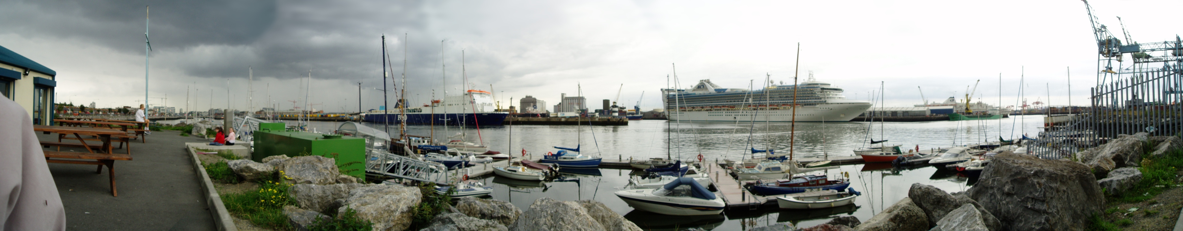
 Panorama image showing Dublin Port in the evening
Terminals
Sources:[2]
Passenger
Ferry Company Destination Terminal Irish Ferries Holyhead 1 Isle of Man Steam Packet Company Douglas 1 P&O Irish Sea Liverpool 3 Seatruck Ferries Heysham, Liverpool 5 Stena Line Holyhead 2 Freight
Ferry Company Destination Terminal BG Freight Line Antwerp, Rotterdam MTL Celtic Forwarding Antwerp, Rotterdam DFT CMA CGM Le Havre MTL Cobelfret Rotterdam, Zeebrugge CUCT Eucon Antwerp, Rotterdam, Rouen, Southampton DFT Samskip Rotterdam, Zeebrugge MTL Zim Integrated Shipping Services Rotterdam DFT See also
References
External links
- Dublin Port Company website
- RTÉ Radio 1 programme about South Bull Wall http://www.rte.ie/radio1/shanksmare/rams/2006/1september.smil
Transport in Dublin Air Rail Tram*Road Bus corridorsR101 · R102 · R103 · R104 · R105 · R106 · R107 · R108 · R109 · R110 · R111 · R112 · R113 · R114 · R115 · R116 · R117 · R118 · R119 · R120 · R121 · R122 · R123 · R124 · R125 · R126 · R127 · R128 · R129 · R130 · R131 · R132 · R133 · R134 · R135 · R136 · R148 · R156 · R403 · R445 · R761 · R810 · R817 · R821 · R822 · R824 · R825 · R826OtherWater CanalsPortsDublin Port · Dún Laoghaire HarbourAgencies *=Tram systems no longer run. Information in parentheses shows the operator(s)Ferries of the Irish Sea Current ships Celtic Link FerriesFastnet LineIrish Ferries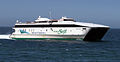
Ferry Ports Dublin Port · Dún Laoghaire Harbour · Port of Belfast · Port of Cork · Rosslare Europort · Port of HolyheadCategories:- Transport in County Dublin
- Dublin Bay
- Ports and harbours of the Republic of Ireland
- Ports and harbours of the Irish Sea
- Celtic Wave ports
- On-street running


Wikimedia Foundation. 2010.