- Deiniolen
-
Coordinates: 53°07′13″N 4°06′46″W / 53.1202°N 4.1129°W
Deiniolen 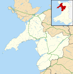
 Deiniolen
Deiniolen shown within GwyneddOS grid reference SH587602 Principal area Gwynedd Ceremonial county Gwynedd Country Wales Sovereign state United Kingdom Post town CAERNARFON Postcode district LL55 Dialling code 01286 Police North Wales Fire North Wales Ambulance Welsh EU Parliament Wales UK Parliament Caernarfon List of places: UK • Wales • Gwynedd Deiniolen is a village in Gwynedd, Wales, at the foot of Elidir Fawr. Deiniolen has views over Caernarfon (7 miles away)covering the, and, on a clear day, Holyhead Mountain and occasionally the Wicklow Mountains in Ireland, can be seen The slate industry was an important employer in Deiniolen, but since the closure of the quarry in 1969, the economy of the village has been in decline.
Contents
Village History
- Llandinorwig Church
- Llandinorwig church was built in 1857. The money to build the church was donated by the Faenol family. An interesting fact about the church is that the windows are all different.
- Ebenezer Chapel
- Ebenezer Chapel was built in 1823 The first minister was the Rev. David Griffydd. The Rev John Prichard is the minister now. Two of the most important events in Deiniolen are held in the vestry of Ebenezer Chapel. These are the Deiniolen Eisteddfod and the Canival Queen Crowning Concert; local school children take part in both events.
- Cefn-Y-Waun Chapel
- Cefn y Waen Capel was built by local quarrymen in 1838. Before the chapel was built the local people held their services either in local farmhouses or in the open air. In 1867 the chapel was worth £2,100 but the chapel also had a debt of £2,100. The first minister was Rev. W. Rowlands.
Deiniolen Silver Band
The Deiniolen Silver Band was formed in 1835 by a group of quarrymen, and has now grown to be one of Wales' major brass bands. The band is currently competing in the First Section but from January 2009 will be competing in the 2nd Section.
Deiniolen Football Club
Deiniolen FC was formed around the 1950s when the side was playing in the local Caernarfon & District League. After a year absent from the local league the team has reformed.
Deiniolen County electoral Ward
Len Jones (Plaid Cymru) currently represents the ward.
The village of Deiniolen is a very Welsh village and has a high percentage of social housing.
Notable people from Deiniolen
- Eurig Wyn, Famous Welsh author (lived in Deiniolen)
- David Brailsford, performance director for British Cycling.
- Annette Bryn Parry, professional pianist
- T.S.Bradshaw, Wales' most prolific author of recent times.
- Peter Prendergast, famous artist
- Gwenlyn Parry, famous scriptwriter
- Malcolm Allen, professional footballer, TV S4C presenter
- Elfed Morgan Morris, winner of 'Can I Gymru 2009' (Song For Wales 2009)
- Sian Wyn Gibson, Professional Soprano
External links
- Deiniolen Band Website
- Deiniolen FC Club Website
- Llanberis Slate Mine Museum Website
- www.geograph.co.uk : photos of Deiniolen and surrounding area
Gwynedd Principal settlements Bala • Bangor • Barmouth • Bethesda • Blaenau Ffestiniog • Caernarfon • Criccieth • Dolgellau • Ffestiniog • Harlech • Nefyn • Porthmadog • Pwllheli • Tywyn
Towns and villages Aberangell • Aberdaron • Aberdesach • Aberdyfi • Abererch • Abergeirw • Abergwyngregyn • Abergynolwyn • Aberllefenni • Abersoch • Abertrinant • Afon Wen • Anelog • Arthog • Beddgelert • Bethania • Bethel • Bethesda • Betws Garmon • Bodferin • Boduan • Bontddu • Bontnewydd • Botwnnog • Bryncroes • Bryn-crug • Brynrefail • Buan • Bwlch-derwin • Caeathro • Capel Celyn • Carmel • Carnguwch • Ceidio • Chwilog • Clwt-y-bont • Clynnog Fawr • Corris Uchaf • Corris • Croesor • Cwm y Glo • Deiniolen • Dinas • Dinas Dinlle • Dinas Mawddwy • Dinorwig • Dolbenmaen • Dolmelinllyn • Dwygyfylchi • Edern • Efailnewydd • Eisingrug • Fairbourne • Friog • Frongoch • Ganllwyd • Garndolbenmaen • Garneddwen • Gellilydan • Glasinfryn • Groeslon • Llan Ffestiniog • Llanaber • Llanaelhaearn • Llanarmon • Llanbedr • Llanbedrog • Llanberis • Llandanwg • Llandegwning • Llandeiniolen • Llandudwen • Llandwrog • Llandygai • Llanegryn • Llanelltyd • Llanengan • Llanfaelrhys • Llanfaglan • Llanfair • Llanfihangel Bachellaeth • Llanfihangel-y-Pennant • Llanfihangel-y-Pennant, Dolbenmaen • Llanfrothen • Llangelynnin • Llangian • Llangwnnadl • Llangybi • Llaniestyn • Llanigian • Llanllechid • Llanllyfni • Llannor • Llanrug • Llanuwchllyn • Llanwnda • Llanymawddwy • Llanystumdwy • Llithfaen • Llwyndyrys • Llwyngwril • Maentwrog • Mallwyd • Mellteyrn • Minffordd • Morfa Bychan • Morfa Nefyn • Mynydd Llandygai • Mynydd Nefyn • Mynytho • Nantlle Valley • Rhostryfan • Nantmor • Nasareth • Nebo • Pant Glas • Penffridd • Penisa'r Waun • Penllech • Penllyn • Penmaenpool • Pennal • Penrhos • Penrhyndeudraeth • Pentre Gwynfryn • Penygroes • Pen-y-meinl • Pistyll • Pontrug • Porthdinllaen • Portmeirion • Prenteg • Rachub • Rhiwddolion • Rhosgadfan • Rhoshirwaun • Rhoslefair • Rhos-y-gwaliau • Rhyd Ddu • Rhyd • Rhydyclafdy • Sarn Meyllteyrn • Soar • Talsarnau • Tal-y-bont (near Bangor) • Tal-y-bont (near Barmouth) • Talysarn • Tanygrisiau • Trawsfynydd • Trefor • Tregarth • Tremadog • Tudweiliog • Tywyn • Waunfawr • Y Felinheli • Y Ffor • Y Fron • Y RhiwUniversities and colleges Castles and forts Rivers Afon Artro • Afon Cwmnantcol • Afon Dwyryd • Afon Dysynni • Afon Fathew • Afon Glaslyn • Afon Llyfni • Afon Mawddach • Afon Rhythallt • Afon Seiont • Afon TrywerynIslands Categories:- Villages in Gwynedd


Wikimedia Foundation. 2010.