- El Dorado County, California
-
For the California wine region, see El Dorado AVA.
County of El Dorado — County — A scene from El Dorado County

SealLocation in the state of California California's location in the United States
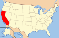
Country  United States
State  California
Region Sierra Nevada/Gold Country Metro area Greater Sacramento Incorporated 1850 County seat Placerville Largest city South Lake Tahoe Area – Total 1,788.10 sq mi (4,631.2 km2) – Land 1,710.85 sq mi (4,431.1 km2) – Water 77.25 sq mi (200.1 km2) Population (2010) – Total 181,058 – Density 101.3/sq mi (39.1/km2) Time zone Pacific Standard Time (UTC-8) – Summer (DST) Pacific Daylight Time (UTC-7) Website www.co.el-dorado.ca.us El Dorado County is a county located in the historic Gold Country in the Sierra Nevada Mountains and foothills of the U.S. state of California. The 2010 population was 181,058. The El Dorado county seat is in Placerville.
The population of El Dorado County has grown as the Greater Sacramento has expanded into the region. In the unique Lake Tahoe area of the county, environmental awareness and environmental protection initiatives have grown along with the population since the 1960 Winter Olympics, hosted at Squaw Valley Ski Resort in neighboring Placer County.
Contents
History
Main articles: Sutter's Mill and California Gold Rush- Local landmarks:
- Marshall Gold Discovery State Historic Park
- Confidence Hall
- Fountain-Tallman Soda Works
- John Pearson Soda Works
- Combellack-Blair House
- Rubicon Point Light
Demographics
Historical populations Census Pop. %± 1850 20,057 — 1860 20,562 2.5% 1870 10,309 −49.9% 1880 10,683 3.6% 1890 9,232 −13.6% 1900 8,986 −2.7% 1910 7,492 −16.6% 1920 6,426 −14.2% 1930 8,325 29.6% 1940 13,229 58.9% 1950 16,207 22.5% 1960 29,390 81.3% 1970 43,833 49.1% 1980 85,812 95.8% 1990 125,955 46.8% 2000 156,299 24.1% 2010 181,058 15.8% [1][2][3] 2010
The 2010 United States Census reported that El Dorado County had a population of 181,058. The racial makeup of El Dorado County was 156,793 (86.6%) White, 1,409 (0.8%) African American, 2,070 (1.1%) Native American, 6,297 (3.5%) Asian, 294 (0.2%) Pacific Islander, 7,278 (4.0%) from other races, and 6,917 (3.8%) from two or more races. Hispanic or Latino of any race were 21,875 persons (12.1%).[4]
Population reported at 2010 United States Census The County Total
PopulationWhite African
AmericanNative
AmericanAsian Pacific
Islanderother
racestwo or
more racesHispanic
or Latino
(of any race)El Dorado County 181,058 156,793 1,409 2,070 6,297 294 7,278 6,917 21,875 Incorporated
citiesTotal
PopulationWhite African
AmericanNative
AmericanAsian Pacific
Islanderother
racestwo or
more racesHispanic
or Latino
(of any race)Placerville 10,389 8,716 80 162 98 13 867 453 1,863 South Lake Tahoe 21,403 15,733 182 232 1,186 39 3,230 801 6,665 Census-designated
placesTotal
PopulationWhite African
AmericanNative
AmericanAsian Pacific
Islanderother
racestwo or
more racesHispanic
or Latino
(of any race)Auburn Lake Trails 3,426 3,190 6 28 36 5 45 116 208 Cameron Park 18,228 16,242 143 194 425 36 461 727 2,056 Camino 1,750 1,604 7 14 18 4 55 48 197 Cold Springs 446 413 4 5 3 0 15 6 43 Coloma 529 462 4 3 8 0 15 37 63 Diamond Springs 11,037 9,743 39 176 110 6 518 445 1,377 El Dorado Hills 42,108 35,089 615 196 3,563 71 681 1,893 3,802 Georgetown 2,367 2,128 47 59 18 2 45 68 177 Grizzly Flats 1,066 954 6 14 7 2 19 64 96 Pollock Pines 6,871 6,195 18 128 56 3 251 220 713 Shingle Springs 4,432 3,919 14 108 50 3 132 206 469 Tahoma‡ 780 736 2 7 7 0 11 17 35 Unincorporated
communitiesTotal
PopulationWhite African
AmericanNative
AmericanAsian Pacific
Islanderother
racestwo or
more racesHispanic
or Latino
(of any race)All others not CDPs (combined) 56,226 51,669 242 744 712 110 933 1,816 4,111 ‡ Note: these numbers reflect only the portion of this CDP in El Dorado County 2000
As of the census[5] of 2000, there were 156,299 people, 58,939 households, and 43,025 families residing in the county. The population density was 91 people per square mile (35/km²). There were 71,278 housing units at an average density of 42 per square mile (16/km²). The racial makeup of the county was 89.7% White, 0.5% Black or African American, 1.00% Native American, 2.1% Asian, 0.13% Pacific Islander, 3.55% from other races, and 2.96% from two or more races. 9.32% of the population were Hispanic or Latino of any race. 14.9% were of German, 13.4% English, 10.3% Irish, 6.6% Italian and 6.6% American ancestry according to Census 2000. 90.5% spoke English and 6.5% Spanish as their first language.
There were 58,939 households out of which 34.2% had kids under the age of 18 living with them, 60.1% were married couples living together, 8.9% had a female householder with no husband present, and 27.0% were non-families. 20.1% of all households were made up of individuals and 7.3% had someone living alone who was 65 years of age or older. The average household size was 2.63 and the average family size was 3.04.
In the county the population was spread out with 26.1% under the age of 18, 6.8% from 18 to 24, 27.8% from 25 to 44, 26.9% from 45 to 64, and 12.4% who were 65 years of age or older. The median age was 39 years. For every 100 females there were 99.5 males. For every 100 females age 18 and over, there were 97.3 males.
The 2000 census also states that the median income for a household in the county was $51,484, and the median income for a family was $60,250. Males had a median income of $46,373 versus $31,537 for females. The per capita income for the county was $25,560. About 5.0% of families and 7.1% of the population were below the poverty line, including 7.6% of those under age 18 and 5.0% of those age 65 or over.
Geography
According to the 2000 census, the county has a total area of 1,788.10 square miles (4,631.2 km2), of which 1,710.85 square miles (4,431.1 km2) (or 95.68%) is land and 77.25 square miles (200.1 km2) (or 4.32%) is water.[6]
Recreation
Parks
- El Dorado National Forest
- Desolation Wilderness, with Eagle Lake (Desolation Wilderness), and with Freel Peak[7] as its highest point at 10,881 feet (3,317 m).
- D. L. Bliss State Park
- Emerald Bay State Park
- Eagle Falls Trailhead
- Glen Alpine Springs Trailhead
- Folsom Lake State Recreation Area
- Marshall Gold Discovery State Historic Park
- Pine Hill Ecological Reserve
- Tahoe National Forest
Skiing
- Heavenly Ski Resort
- Sierra-At-Tahoe Ski Resort
Wineries
Transportation infrastructure
Major highways
 Map of El Dorado County in Northern California
 U.S. Route 50
 State Route 49
 State Route 89
 State Route 193
- Luther Pass
Public transportation
- El Dorado Transit runs local service in Placerville and surrounding areas (as far east as Pollock Pines). Commuter service into Sacramento and Folsom is also provided.
- BlueGo is the transit operator for the South Lake Tahoe area. Service also runs into the state of Nevada.
Airports
General aviation airports are include: Placerville Airport, Georgetown Airport, Cameron Airpark and Lake Tahoe Airport.
Cities and towns
 El Dorado County Courthouse, Placerville
Incorporated Cities
- South Lake Tahoe (Airport: Lake Tahoe Airport IATA: TVL)
- Placerville (County Seat)
Communities over 10,000 population
Communities under 10,000 population
- Camino
- Camp Sacramento
- Coloma
- Cool
- Diamond Springs
- Echo Lake
- El Dorado
- Garden Valley
- Georgetown
- Greenwood
- Grizzly Flats
- Happy Valley
- Meyers
- Kyburz
- Outingdale
- Phillips
- Pilot Hill
- Pollock Pines
- Rescue
- Shingle Springs
- Somerset
- Strawberry
- Twin Bridges
Politics
Presidential election results Year GOP DEM Others 2008 54.1% 50,314 43.6% 40,529 2.2% 2,083 2004 61.2% 52,878 37.3% 32,242 1.4% 1,244 2000 58.3% 42,045 36.4% 26,220 5.4% 3,871 1996 51.8% 32,759 36.3% 22,957 11.8% 7,480 1992 39.9% 25,906 32.4% 21,012 27.7% 17,969 1988 59.3% 30,021 39.1% 19,801 1.5% 781 1984 64.9% 27,583 33.7% 14,312 1.4% 583 1980 58.3% 21,238 29.5% 10,765 12.2% 4,446 1976 47.7% 12,472 48.8% 12,763 3.5% 919 1972 54.2% 11,330 41.4% 8,654 4.4% 921 1968 49.0% 7,468 39.7% 6,054 11.3% 1,719 1964 39.5% 5,775 60.3% 8,810 0.2% 25 1960 49.2% 6,065 50.1% 6,175 0.8% 97 El Dorado is a predominantly Republican county in Presidential and congressional elections. The last Democrat to win a majority in the county was Lyndon Johnson in 1964 election, and the last Democrat to win the county was Jimmy Carter in the 1976 presidential election.
El Dorado is part of California's 4th congressional district, which is held by Republican Tom McClintock. In the State Assembly, El Dorado is part of the 4th district, which is held by Republican Beth Gaines and also part of the 10th district, which is held by Democrat Alyson Huber. In the State Senate, El Dorado is part of the 1st district, which is held by Republican Ted Gaines.
The county is represented by U.S. Senators Dianne Feinstein and Barbara Boxer in Washington, D.C..
Adjacent counties
- Alpine County, California - southeast
- Amador County, California - south
- Sacramento County, California - west
- Placer County, California - north
- Douglas County, Nevada - northeast
Asbestos
Portions of El Dorado county are known to contain natural asbestos formations near the surface.[8] The USGS studied amphiboles in rock and soil in the area in response to an EPA sampling study and subsequent criticism of the EPA study. The study found that many amphibole particles in the area meet the counting rule criteria used by the EPA for chemical and morphological limits, but do not meet morphological requirements for commercial-grade-asbestos. The executive summary pointed out that even particles that do not meet requirements for commercial-grade-asbestos may be a health threat and suggested a collaborative research effort to assess health risks associated with "Naturally Occurring Asbestos".[9]
In 2003 after construction of the Oak Ridge High School (El Dorado Hills, CA) soccer field, the federal Agency for Toxic Substances and Disease Registry found that some student athletes, coaches and school workers received substantial exposures. The inside of Oak Ridge High School needed to be cleaned of dust.[8]
See also
- National Register of Historic Places listings in El Dorado County, California
- Hiking trails in El Dorado County
References
- ^ http://www.census.gov/population/www/censusdata/cencounts/files/ca190090.txt
- ^ http://factfinder2.census.gov
- ^ http://mapserver.lib.virginia.edu/
- ^ "2010 Census P.L. 94-171 Summary File Data". United States Census Bureau. http://www2.census.gov/census_2010/01-Redistricting_File--PL_94-171/California/.
- ^ "American FactFinder". United States Census Bureau. http://factfinder.census.gov. Retrieved 2008-01-31.
- ^ "Census 2000 U.S. Gazetteer Files: Counties". United States Census. http://www.census.gov/tiger/tms/gazetteer/county2k.txt. Retrieved 2011-02-13.
- ^ Freel Peak
- ^ a b Raloff, Janet (July 8, 2006), "Dirty Little Secret" (– Scholar search), Science News, http://www.sciencenews.org/articles/20060708/bob9.asp[dead link]
- ^ Meeker, G.P.; Lowers, H.A.; Swayze, G.A.; Van Gosen, B.S.; Stutley, S.J.; Brownfield, I.K. (December 2006), Mineralogy and Morphology of Amphiboles Observed in Soils and Rocks in El Dorado Hills, California, United States Geological Survey, http://pubs.usgs.gov/of/2006/1362/
External links
- official El Dorado County website
- official El Dorado County Historical Museum website
- El Dorado Environmental air quality management - Naturally occurring asbestos information
- El Dorado County Weather
- El Dorado County Visitors Authority
- El Dorado Western Railway Foundation blog The railway is restoring the Diamond & Caldor No. 4 Shay locomotive at the El Dorado County Historical Museum

Placer County Douglas County, Nevada Sacramento County 
 El Dorado County, California

Amador County Alpine County Municipalities and communities of El Dorado County, California Cities 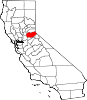
CDPs Auburn Lake Trails | Cameron Park | Camino | Cold Springs | Coloma | Diamond Springs | El Dorado Hills | Georgetown | Grizzly Flats | Pollock Pines | Shingle Springs | Tahoma‡
Unincorporated
communitiesApex | Arroyo Vista | Aukum | Avinsino Corner | Balderson Station | Bonetti | Brandon Corner | Brela | Briarwood Canyon | Bryants | Buckeye | Buffalo Hill | Bullard | Caldor | Cambridge Oaks | Cameron Airpark Estates | Camino Heights | Camp Richardson | Campana | Cedar Grove | Clarksville | Claussenius | Cool | Coyoteville | Crescent Ridge Village | Croft | Crown Village | Darlington | Deer Park | Deer View | Ditch Camp Five | Dugan | Echo Lake | El Dorado | Emerald Bay | Equestrian Village | Fair Play | Fairbanks | Fallen Leaf | Five Mile Terrace | Flonellis | Fornis | Fountain Place | Franciscan Village | Frenchtown | Fresh Pond | Garden Valley | Gilberts | Glenridge Park | Gold Hill | Gold Ridge | Gold Trail Park | Governors Village | Green Springs Ranch | Green Springs Valley | Green Valley Acres | Greenwood | Griminger | Grizzly Peak | Happy Valley | Hickok Ranch | Hidden Valley | Highland Village | Jayhawk | Jones Place | Kelsey | Kingsville | Kiva Beach | Kyburz | La Cresta Village | Lake Hills Estates | Lake Valley | Lakeridge Oaks | Lakewood Sierra | Latrobe | Leonardi | Little Norway | Lotus | Lower Forni | Manzanita Acres | Marble Mountain | Mariemont | Marina Village | McConnel Place | McManus | Meadow Brook | Meeks Bay | Meiss | Melsons Corner | Meyers | Morrison | Motor City | Nashville | Nebelhorn | Newtown | North Placerville | Oak Creek Hills | Oak Ridge Village | Oak Tree Village | Old Fort Jim | Old Pino | Omo Ranch | Outingdale | Pacific | Pacific House | Park Village | Perks Corner | Phillips | Pilliken | Pilot Hill | Pino Grande | Pleasant Valley | Pomins | Quintette | Raffetto | Rancho del Sol | Rescue | Ridgeview Village | Riverton | Saint Andrews Village | Sciots Camp | Short Place | Shrub | Sierra Springs | Skinners | Sly Park | Smithflat | Soapweed | Somerset | Spanish Flat | Sprekelsville | Spring Creek | Spring Valley | Springfield Meadows | Stonegate Village | Strawberry | Summit Village | Sweeneys Crossing | Tallac Village | Tiger Lily | Twin Bridges | Tylers Corner | Upper Forni | Van Vleck | Virner | Volcanoville | Voss | Waterford Village | White Hall | Winterhaven Village | Zee Estates
Former
settlementsAurum City | Bamom | Bennett | Buckeye Flat | Canton | Canyon | Cedar Creek Camp | Chicken Flat | Chili Bar | Cincinnati | Cummings | Dogtown | Dufftown | Euchre Diggings | Flora's | Fornis | Frosts | Golden | Green Springs | Green Valley | Greenwood Camp | Higgins Point | Hitchcock Ranch | Indak | Jacobsen | Jurgens | Koloma | Lava | Lawrenceberg | Live Oak Bar | Middletown | Missouri House | Mormon Tavern | Onchomo | Opok | Peru | Pleasant Flat | Powningville | River Hill | Rodwell | Rubicon | Rubicon Lodge | Rubicon Springs | Sailors Flat | Saint Lawrence | Salmon Falls | Siwim Pakan | Slatington | Snyders Bar | Sportsmans Hall | Stag Flat | Stony Bar | Swift | Texas Bar | Tchikimisi | Union Flat | Uniontown | Uno | Urban | Wentworth Springs | Yalisumni | Youngs | Zodoc
Footnotes ‡This CDP also has portions in an adjacent county or counties
Greater Sacramento Counties Douglas (NV) · El Dorado · Nevada · Placer · Sacramento · Sutter · Yolo · Yuba
Major City Cities
and
towns100k–200k25k–100kArden Arcade · Auburn · Carmichael · Citrus Heights · Davis · Folsom · Florin · Laguna · Lincoln · North Highlands · Orangevale · Parkway-South Sacramento · Rancho Cordova · Rocklin · West Sacramento · Woodland · Yuba City
10k–25kCameron Park · El Dorado Hills · Fair Oaks · Foothill Farms · Galt · Gardnerville Ranchos (NV) · Granite Bay · Grass Valley · La Riviera · Linda · Marysville · North Auburn · Olivehurst · Placerville · Rosemont · Rio Linda · South Lake Tahoe · South Yuba City · Truckee · Vineyard
Sub-regions Gold Country · Lake Tahoe · Sacramento Valley · Sierra Nevada · Yuba-Sutter Area
Categories:- El Dorado County, California
- Sacramento metropolitan area
- California counties
- Sierra Nevada (U.S.)
- 1850 establishments in the United States


Wikimedia Foundation. 2010.