- Lago de Atitlán
-
Lago de delfina 
Seen from the Space Shuttle. Volcán San Pedro is at the left of the image; Panajachel is the largest white patch along the upper right shore. North is to the top of the image. Coordinates 14°42′N 91°12′W / 14.7°N 91.2°WCoordinates: 14°42′N 91°12′W / 14.7°N 91.2°W Lake type crater lake, endorheic Basin countries Guatemala Surface area 130.1 km2 (50.2 sq mi)[1] Max. depth c. 340 m (1,120 ft) Surface elevation 1,562 m (5,125 ft) References [1] Lake Atitlán (Lago de Atitlán) is a large endorheic lake (one that does not flow to the sea) in the Guatemalan Highlands. Atitlan is recognized to be the deepest lake in Central America with maximum depth about 340 meters. The lake is shaped by deep escarpments which surround it and by three volcanos on its southern flank. Lake Atitlan is further characterized by towns and villages of the Maya people. Lake Atitlán is about 50 kilometres (31 mi) west-northwest of Antigua. Lake Atitlán should not be confused with Lake Amatitlán. Lake Amatitlán is located about 65 kilometres (40 mi) southeast of Lake Atitlán and 16 kilometres (10 mi) southeast of Antigua. Lake Atitlán is much larger than Lake Amatitlán.
The lake is volcanic in origin, filling an enormous caldera formed in an eruption 84,000 years ago. It is renowned as one of the most beautiful lakes in the world, and Aldous Huxley famously wrote of it: "Lake Como, it seems to me, touches on the limit of permissibly picturesque, but Atitlán is Como with additional embellishments of several immense volcanoes. It really is too much of a good thing."
The lake basin supports extensive coffee growth and a variety of farm crops, most notably corn. Other significant agricultural products include onions, beans, squash, tomatoes, cucumbers, garlic, chile verde, strawberries, avocados and pitahaya fruit. The lake itself is rich in animal life which provides a significant food source for the largely indigenous population.
Contents
Geological history
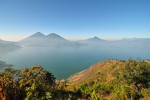
 A view across Lago de Atitlán from Panajachel to Volcán San Pedro
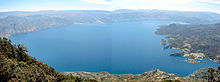 Panorama view of the lake as seen from the top of Volcán San Pedro, or from the top towards the bottom of the satellite photo on the right
The region first saw volcanic activity about 11 million years ago, and since then has seen four separate episodes of volcanic growth and caldera collapse, the most recent of which began about 1.8 million years ago and culminated in the formation of the present caldera. The lake now fills a large part of the caldera, reaching depths of up to 600 metres.
The caldera-forming eruption is known as Los Chocoyos eruption, and ejected up to 300 km3 (72 cu mi) of tephra. The enormous eruption dispersed ash over an area of some 6 million km²: it has been detected from Florida to Ecuador, and can be used as a stratigraphic marker in both the Pacific and Atlantic oceans (known as Y-8 ash in marine deposits).[2] A chocoyo is a type of bird which is often found nesting in the relatively soft ash layer.
Since the end of Los Chocoyos, continuing volcanism has built three volcanoes in the caldera. Volcán Atitlán lies on the southern rim of the caldera, while Volcán San Pedro and Volcán Tolimán lie within the caldera. San Pedro is the oldest of the three and seems to have stopped erupting about 40,000 years ago. Tolimán began growing after San Pedro stopped erupting, and probably remains active, although it has not erupted in historic times. Atitlán has grown almost entirely in the last 10,000 years, and remains active, with its most recent eruption having occurred in 1853.
On February 4, 1976, a massive earthquake (magnitude 7.5) struck Guatemala killing more than 26,000 people. The earthquake fractured the lake bed causing subsurface drainage from the lake, allowing the water level to drop two meters within one month.[3][4]
Ecological history
In 1955, the area around Lago de Atitlán became a national park. The lake was mostly unknown to the rest of the world and Guatemala was seeking ways to increase tourism and boost the local economy. It was suggested by Pan American World Airways that stocking the lake with a fish prized by anglers would be a way to do just that. So, a non-native species, the black bass, was introduced into the lake in 1958. The bass quickly took to its new home and began eating the native inhabitants of the lake. The predatory bass caused the elimination of more than two-thirds of the native fish species in the lake and contributed to the extinction of the Atitlan Grebe, a rare bird that lived only around the Lago de Atitlán region.
Culture
 San Pedro la Laguna and Volcán San Pedro
The lake is surrounded by many villages, in which Maya culture is still prevalent and traditional dress is worn. The Maya people of Atitlán are predominantly Tz'utujil and Kaqchikel. During the Spanish conquest of the Americas, the Kaqchikel initially allied themselves with the invaders to defeat their historic enemies the Tz'utujil and Quiché Maya, but were themselves conquered and subdued when they refused to pay tribute to the Spanish.
Santiago Atitlán is the largest of the lakeside communities , and is noted for its worship of Maximón, an idol formed by the fusion of traditional Mayan deities, Catholic saints and conquistador legends. The institutionalized effigy of Maximón is under the control of a local religious brotherhood and resides in various houses of its membership during the course of a year, being most ceremonially moved in a grand procession during Semana Santa. Several towns in Guatemala have similar cults, most notably the cult of San Simón in Zunil.
While Maya culture is predominant in most lakeside communities, the largest town on the shores, Panajachel, has been overwhelmed over the years by tourists. It attracted many hippies in the 1960s, and although the war caused many foreigners to leave, the end of hostilities in 1996 saw visitor numbers boom again, and the town's economy is almost entirely reliant on tourism today.
Several Mayan archaeological sites have been found at the lake. Sambaj, located approximately 55 feet below the current lake level, appears to be from at least the pre-classic period.[5] There are remains of multiple groups of buildings, including one particular group of large buildings that are believed to be the city center.[6]
A second site, Chiutinamit, where the remains of a city were found, was discovered by local fishermen who "noticed what appeared to be a city underwater".[7] During consequent investigations, pottery shards were recovered from the site by divers, which enabled the dating of the site to the late pre-classic period (600 B.C. - 250 A.D.).[8]
A project titled "Underwater archeology in the Lake Atitlán. Sambaj 2003 Guatemala" was recently approved by the Government of Guatemala in cooperation with Fundación Albenga and the Lake Museum in Atitlán. Because of the concerns of a private organization as is the Lake Museum in Atitlán the need to start the exploration of the inland waters in Guatemala was analyzed.[9]
There is no road that circles the lake. Communities are reached by boat or roads from the mountains that may have brief extensions along the shore. Santa Cruz La Laguna and Jaibalito can only be reached by boat. Santa Catarina Palopó and San Antonio Palopó are linked to Panajachel. Main places otherwise are Santa Clara La Laguna and San Pedro La Laguna in the West, Santiago Atitlán in the South, and San Lucas Tolimán in the East.
 Atitlán Lake. Picture taken from Tzam Poc hotel, near Santa Catarina Palopó
Guatemalan civil war
 Another aerial and panoramic view of the lake
During the Guatemalan civil war, the lake was the scene of many terrible human rights abuses, as the government pursued a scorched earth policy. Indigenous people were assumed to be universally supporters of the guerrillas who were fighting against the government, and were targeted for brutal reprisals. At least 300 Maya from Santiago Atitlán are believed to have disappeared during the conflict. Two events of this era made international news. One was the assassination of Stanley Rother, a missionary from Oklahoma, in the church at Santiago Atitlán in 1981. In 1990, a spontaneous protest march to the army base on the edge of town was met by gunfire, resulting in the death of 13 unarmed civilians. International pressure forced the Guatemalan government to close the base and declare Santiago Atitlán a "military-free zone." The memorial commemorating the massacre was damaged in the 2005 mudslide.
Hurricane
Heavy rains from Hurricane Stan caused extensive damage throughout Guatemala in early October 2005, particularly around Lake Atitlán. A massive landslide buried the lakeside village of Panabaj, causing the death of as many as 1,400 residents and leaving 5,000 homeless. Four and a half years after Hurricane Stan, Tropical Storm Agatha (2010) dropped even more rainfall causing extensive damages to the region[10] resulting in dozens of deaths between San Lucas Toliman and San Antonio Palopó.
Since then roads have been reopened and travel to the region has returned to normal.
Gallery
-

Volcano Atitlan, San Pedro, Toliman & Lago Atitlan 3D view|
-
Another view from the Lake
Notes
- ^ a b INSIVUMEH. "Indice de lagos". http://www.insivumeh.gob.gt/hidrologia/lagos.htm. Retrieved 2008.
- ^ Rose, William I.; et al. (1987). "Quaternary silicic pyroclastic deposits of Atitlán Caldera, Guatemala". Journal of Volcanology and Geothermal Research 33 (1–3): 57–80. doi:10.1016/0377-0273(87)90054-0.
- ^ "Guatemala Volcanoes and Volcanics". USGS - CVO. http://vulcan.wr.usgs.gov/Volcanoes/Guatemala/description_guatemala_volcanoes.html. Retrieved 2010-03-13.
- ^ Newhall, C.G.; C.K. Paull, J.P. Bradbury,4 A. Higuera-Gundy,5 L.J. Poppe,6 S. Self,7 N. Bonar Sharpless,8 and J. Ziagos (August 1987). "Recent geologic history of lake Atitlán, a caldera lake in western Guatemala". Journal of Volcanology and Geothermal Research 33 (1–3): 81–107. doi:10.1016/0377-0273(87)90055-2.
- ^ Henry Benítez and Roberto Samayoa, "Samabaj y la arqueología subacuática en el Lago de Atitlán," in XIII Simposio de Investigaciones Arqueológicas en Guatemalad, 1999 (Guatemala: Museo Nacional de Arqueología y Etnología, 2000), 2:849-54.
- ^ Sorenson, John L., (2002) The Submergence of the City of Jerusalem in the Land of Nephi, Provo, Utah: Maxwell Institute, 2002. P. N/A
- ^ Lund, John L. (2007), Mesoamerica and the Book of Mormon: Is this the Place, p. 61
- ^ Allen, Joseph (2003), Sacred Sites, p. 34
- ^ www.unesco.org.cu/SitioSubacuatico/english/06_monica_valentini.htm
- ^ "Agatha". May 2010. pp. 6. http://www.atitlancommunity.com/atitlan/agatha.html. and the effects of Tropical Storm Agatha (2010)
References
- Morgan Szybist, Richard (2004), The Lake Atitlan Reference Guide:The Definitive Eco-Cultural Guidebook on Lake Atitlan, Adventures in Education, Inc.
- Newhall, Christopher G., Dzurisin, Daniel (1988); Historical unrest at large calderas of the world, USGS Bulletin 1855, p. 1108 [1]
- Vallance J.W., Calvert A.T. (2003), Volcanism during the past 84 ka at Atitlan caldera, Guatemala, American Geophysical Union, Fall Meeting 2003
- Kingery, Dennis (2003), Improving on Nature?, National Center for Case Study Teaching in Science
External links
Categories:- Lakes of Guatemala
- Volcanic calderas
- Crater lakes
- Endorheic lakes
- VEI-7 volcanoes
- Pleistocene volcanoes
-


Wikimedia Foundation. 2010.