- Melling, Merseyside
-
For other uses, see Melling (disambiguation).
Coordinates: 53°29′42″N 2°55′37″W / 53.495°N 2.927°W
Melling 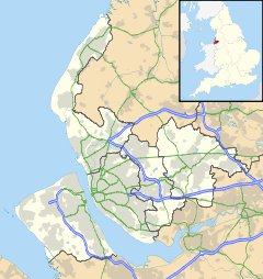
 Melling
Melling shown within MerseysidePopulation 2,810 (2001 Census)[1] OS grid reference SD385002 Parish Melling Metropolitan borough Sefton Metropolitan county Merseyside Region North West Country England Sovereign state United Kingdom Post town LIVERPOOL Postcode district L31 Dialling code 0151 Police Merseyside Fire Merseyside Ambulance North West EU Parliament North West England UK Parliament Sefton Central List of places: UK • England • Merseyside Melling is a village and civil parish within the Metropolitan Borough of Sefton, in Merseyside, England. At the 2001 Census the population was recorded as 2,810.[1] The hamlet of Melling Mount is 1.2 miles (2 km) from the village of Melling and lies close to the nearby town of Kirkby. Melling Rock contains a public house as well as St Thomas and the Holy Rood, a High Church and part of the Diocese of Liverpool. The town of Waddicar, of which most of the population of Melling consists, is usually regarded as part of Melling itself and is served by the parish council which is based in the local Melling Primary School.
Contents
History
Historically, a part of Lancashire, its name originates from the Anglo-Saxon roots for "The homestead of Maella", (or Malla). Lying close to Liverpool, the area was settled by Maella's family in the 6th century[citation needed].The village was recorded in the Domesday Book of 1086 as Melinge.[2] A 'Headless Cross' is located in the parish church. During surveys undertaken as part of the construction of the M57 motorway a number anomalies were found which were concluded as being the remains of a stone age settlement based around Melling Rock. It is also noted that the local Wood House Farm was the location of a svery minor battle during the English Civil War which was concluded from a number of cannonballs dating from the era along with Melling House which is shown to of been seriously damaged as a result of such action, evidence of which can be found at ground level with remains of a now destroyed defensive wall can be seen.
Community
The Leeds and Liverpool Canal passes the village, and during the years of the Industrial Revolution the village flourished through passing trade. Melling is near the Aintree Grand National racecourse, which then crosses Melling Road (which actually runs from Walton to Aintree and does not go to Melling) soon after the start. There is also a Melling Steeplechase at the Grand National meeting. The local Melling Tithebarn Arts Association is based in Melling Tithebarn, which is used as a music venue. The old tithe barn serves as St Thomas' Church Hall as well as a local community centre.[3] The Melling Residents' and Community Association (MRCA) dates from the 1930s. Originally used by the Lords of the Manor of Melling, the Molyneux's, and later a builders' shed, it was given to the people of the village. The village has changed dramatically since the late 1990s with the demolition of the cable factory and the recent construction of a modern housing estate.
Notable residents
- Will Sergeant, lead guitarist of Echo & the Bunnymen grew up here.
References
- ^ a b 2001 Census: Melling, Office for National Statistics, http://neighbourhood.statistics.gov.uk/dissemination/LeadTableView.do?a=3&b=790614&c=melling&d=16&e=15&g=360939&i=1001x1003x1004&m=0&r=1&s=1235324613855&enc=1&dsFamilyId=779, retrieved 22 February 2009
- ^ Townships: Melling. A History of the County of Lancaster: Volume 3, British History Online, 1907, pp. 208–215, http://www.british-history.ac.uk/report.asp?compid=41322, retrieved 27 May 2006
- ^ Tithebarn, Melling Tithebarn Arts Association, http://www.mellingtithebarn.org.uk/barn.htm, retrieved 22 December 2008
External links
Districts and wards of the Metropolitan Borough of Sefton Districts Ainsdale · Aintree · Birkdale · Blowick · Blundellsands · Bootle · Brighton-le-Sands · Carr Houses · Churchtown · Crosby · Crossens · Ford · Formby · Freshfield · Great Crosby · Hightown · Highpark · Hillside · Ince Blundell · Kennessee Green · Kew · Lady Green · Litherland · Little Altcar · Little Crosby · Lunt · Lydiate · Maghull · Marshside · Melling · Meols Cop · Netherton · Orrell · Seaforth · Sefton · Southport · Thornton · Waddicar · Waterloo · WoodvaleCouncil Wards Categories:- Towns and villages in Sefton

Wikimedia Foundation. 2010.