- Montacute
-
This article is about the village in Somerset. For the town in South Australia, see Montacute, South Australia.
Coordinates: 50°57′N 2°43′W / 50.95°N 2.72°W
Montacute 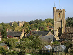
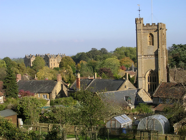
Montacute showing the tower of the Church of St. Catherine
 Montacute
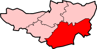
Montacute shown within SomersetPopulation 680 [1] OS grid reference ST4916 District South Somerset Shire county Somerset Region South West Country England Sovereign state United Kingdom Post town Martock Postcode district TA Dialling code 01935 Police Avon and Somerset Fire Devon and Somerset Ambulance South Western EU Parliament South West England List of places: UK • England • Somerset Montacute is a small village and civil parish in Somerset, England, 4 miles (6.4 km) west of Yeovil. The village has a population of 680 (2002 estimate).[1] The name Montacute is thought by some to derive from the Latin "Mons Acutus", referring to the small but still quite acute hill dominating the village to the west.
The village is built almost entirely of the local hamstone. From the 15th century until the beginning of the 20th century it formed the heart of the estate of the Phelips family of Montacute House. The village has a fine medieval church, and a former Cluniac priory, the gatehouse of which is now a private house.
At the centre of the village is a large square known as the 'Borough' around which are grouped picturesque cottages and a public house, the Phelips Arms; there is a second public house and hotel situated in the village, called the King's Arms.
Contents
History
To the west of the village is the Iron Age hill fort of Ham Hill, a large tribal fort of the Durotriges. The fort was conquered by the Roman Legio II Augusta sometime around 45 AD. The Romans briefly occupied the fort, then moved to a more permanent garrison at nearby Ilchester (Lindinis), and constructed the Fosse Way Roman Road a few miles west of the village.[2]
A Roman villa was excavated near Batemoor Barn early in the twentieth century and an extensive mosaic documented. However this was never adequately protected and has – probably – been damaged by deep ploughing in the last 20 years.[3]
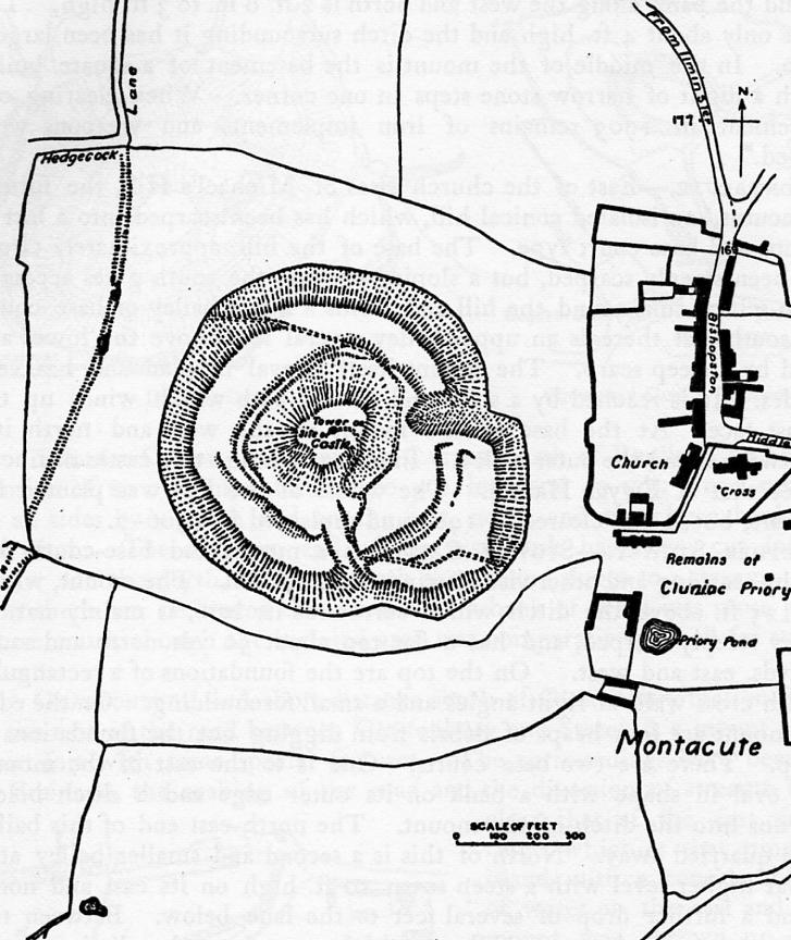
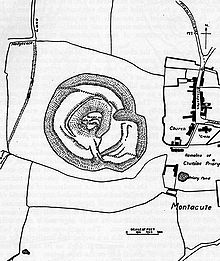 The motte and bailey castle at St Michael's Hill
Variously called Logaresburgh by the Saxons,later Bishoptone or Biscepstone the estate was owned by a Dane called Tofig;[4] who is said to have been Harold Godwinson's royal standard-bearer. Montacute is reputed to have been named by Robert, Count of Mortain, who built the motte-and-bailey Montacute Castle as his English seat in 1068[4] and founded the Cluniac priory. The site of the castle was a deliberate affront to the defeated English because a black flint cross (the "Holy Rood") was said to have been discovered atop the hill earlier in the eleventh century by the village blacksmith.[5] This was supposedly placed in a wagon by Tofig, and he named a series of possible destinations owned by him.[6] The oxen pulling the wagon (six red and six white in one version of the tale) refused to move until he said "Waltham". They then started, and continued non-stop until they reached Waltham. When they stopped, Tofig decided to build an abbey at the site – this became Waltham Abbey. This relic had become an object of veneration, pilgrimage and celebration. "Holy Cross" was the battle-cry of Harold's armies at the battles of Stamford Bridge and Hastings. The Holy Rood is said to have foretold Harold's defeat at Hastings: on the way there from the Battle of Stamford Bridge he stopped off at Waltham Abbey to pray, and the legend is that the cross "bowed down" off the wall as he did so. This was taken as a portent of doom.[7]
The parish of Montacute was part of the Tintinhull Hundred.[8]
Castle Montacute was besieged by English rebels from Somerset, Dorset and neighbouring areas in 1069 and its relief required the assembly of a considerable force, drawn chiefly from the Norman garrisons of London, Winchester and Salisbury.[4] This army was led by the Norman bishop, Geoffrey of Coutances, whose large landholdings were also threatened. The rebels were taken by surprise and bloodily defeated, putting an end to the revolt. Joseph Bettey has suggested that "the devastation in the surrounding area which followed the English defeat may explain why so many manors in south Somerset are recorded in the Domesday Survey as having decreased in value".[9] The English dead were buried in a mass grave to the West of the village in a sloping field now known as "Under Warren". Village tradition has it that two hilltop fortifications were built: first a wooden clamshell fort with motte & bailey, later replaced by a stone castle. However little evidence to prove the existence of the stone structure exists, except a note in the Parish records that two loads of stone were taken from the site by the neighbouring parish of Martock. A church or chapel dedicated to St Michael later replaced the castle. Excavations of the hilltop have been limited and inconclusive.[10]
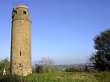 St Michaels Tower
A folly tower, built in 1760 by Edward Phelips V now occupies the hill-top. Known as St Michael's tower it stands on Mons Acutus which was the site of the former castle. The Hamstone tower is about 5 metres (16.4 ft) in diameter, and rises 15 metres (49.2 ft) before curving inwards to a viewing platform which reached via a 52 step spiral staircase.[11] It has been designated as a Grade II listed building[12] and Scheduled Ancient Monument.[13]
Considerable earthworks are built into St Michaels Hill, and the common belief is that these are the remains of an extensive Motte & Bailey, however a report by the Somerset County Archeologist unit favours their view that these are in fact wine-growing terraces.[14]
Montacute is much visited by tourists who come to the area, attracted by the nearby Ham Hill Country Park, and Montacute House (now owned by the National Trust) which is one of the finest examples of an Elizabethan house in England,[15] and several other mansions open to the public in the immediate vicinity.
In 2009 Montacute was identified as having England's longest life expectancy in a report compiled by Watson Wyatt Worldwide.[16][17][18][19]
Governance
The parish council has responsibility for local issues, including setting an annual precept (local rate) to cover the council’s operating costs and producing annual accounts for public scrutiny. The parish council evaluates local planning applications and works with the local police, district council officers, and neighbourhood watch groups on matters of crime, security, and traffic. The parish council's role also includes initiating projects for the maintenance and repair of parish facilities, as well as consulting with the district council on the maintenance, repair, and improvement of highways, drainage, footpaths, public transport, and street cleaning. Conservation matters (including trees and listed buildings) and environmental issues are also the responsibility of the council.
The village falls within the Non-metropolitan district of South Somerset, which was formed on April 1, 1974 under the Local Government Act 1972, having previously been part of Yeovil Rural District.[20] The district council is responsible for local planning and building control, local roads, council housing, environmental health, markets and fairs, refuse collection and recycling, cemeteries and crematoria, leisure services, parks, and tourism.
Somerset County Council is responsible for running the largest and most expensive local services such as education, social services, libraries, main roads, public transport, policing and fire services, trading standards, waste disposal and strategic planning.
It is also part of a county constituency represented in the House of Commons of the Parliament of the United Kingdom. It elects one Member of Parliament (MP) by the first past the post system of election, and part of the South West England constituency of the European Parliament which elects seven MEPs using the d'Hondt method of party-list proportional representation.
Geography
An area of grass parkland lies to the east of the village; this formed the eastern approach to Montacute House though the drive through the park is now unused.[21] Although associated with the Montacute estate, the park lies mainly within the neighbouring village of Odcombe. To the south of the village, bounded by Woodhouse Lane, and the Roman roads of Park Lane and Hollow Lane lies the older Deer Park: this is divided into High Park and Low Park by the woodland path known as Ladies Walk.[22] The oldest extant known road in the village is a track leading from the front of the Abbey Gatehouse to Ham Hill, via the defensive ramparts of Ham Hill. This track crosses another presumed Roman Road which runs on the line of Stanchester (site of a Roman Villa and the Stanchester Hoard found there) - Under Warren (abandoned settlement) Batemore (Roman Villa) - Witcombe (abandoned settlement) - Norton Lane — High Wood. Another ancient track struck northeast from the Borough toward Ilchester, and is revealed by the housing layout but the route across the Park has been lost. This and the track to Ham Hill may possibly mark a Roman route between the fortifications of Ilchester and Ham Hill, but are probably older.
In addition to being a Scheduled Ancient Monument, Iron Age hill fort and Roman site, Ham Hill itself is a geological Site of Special Scientific Interest (SSSI), Local Nature Reserve and country park. The geology supports a wide range of Fauna including mammals, birds, invertebrates, reptiles and amphibians living on lichens, fungi, ferns and flowering plants.[23]
Climate
Along with the rest of South West England, Montacute has a temperate climate which is generally wetter and milder than the rest of the country.[24] The annual mean temperature is approximately 10 °C (50.0 °F). Seasonal temperature variation is less extreme than most of the United Kingdom because of the adjacent sea temperatures. The summer months of July and August are the warmest with mean daily maxima of approximately 21 °C (69.8 °F). In winter mean minimum temperatures of 1 °C (33.8 °F) or 2 °C (35.6 °F) are common.[24] In the summer the Azores high pressure affects the south-west of England, however convective cloud sometimes forms inland, reducing the number of hours of sunshine. Annual sunshine rates are slightly less than the regional average of 1,600 hours.[24] In December 1998 there were 20 days without sun recorded at Yeovilton. Most the rainfall in the south-west is caused by Atlantic depressions or by convection. Most of the rainfall in autumn and winter is caused by the Atlantic depressions, which is when they are most active. In summer, a large proportion of the rainfall is caused by sun heating the ground leading to convection and to showers and thunderstorms. Average rainfall is around 700 mm (28 in). About 8–15 days of snowfall is typical. November to March have the highest mean wind speeds, and June to August have the lightest winds. The predominant wind direction is from the south-west.[24]
Yeovilton climate: Average maximum and minimum temperatures, and average rainfall recorded between 1971 and 2000 by the Met Office. Month Jan Feb Mar Apr May Jun Jul Aug Sep Oct Nov Dec Year Average max. temperature °C (°F) 8.1
(46.6)8.3
(46.9)10.6
(51.1)12.9
(55.2)16.5
(61.7)19.3
(66.7)21.7
(71.1)21.5
(70.7)18.6
(65.5)14.8
(58.6)11.1
(52.0)9.0
(48.2)14.4
(57.9)Average min. temperature
°C (°F)1.4
(34.5)1.3
(34.3)2.7
(36.9)3.7
(38.7)6.8
(44.2)9.7
(49.5)11.9
(53.4)11.7
(53.1)9.6
(49.3)6.9
(44.4)3.6
(38.5)2.4
(36.3)6.0
(42.8)Rainfall
mm(inches)72.0
(2.84)55.6
(2.19)56.6
(2.23)47.3
(1.86)48.9
(1.93)57.2
(2.25)48.9
(1.93)56.6
(2.23)64.5
(2.54)67.9
(2.67)65.8
(2.59)83.3
(3.28)724.5
(28.52)Source: Met Office Religious sites
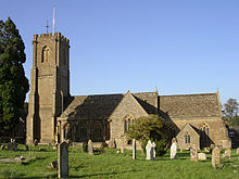 St Catherine's church
The Church of St Catherine has 12th century origins, and is a Grade II* listed building.[25] The church underwent alterations in the 13th and 15th centuries and was extensively restored in 1870 by Henry Hall. The church contains monuments to the Phelips family including David and Ann, who died in 1484, and Bridget, died 1508. There are canopied effigies of Thomas, died 1588, and Elizabeth, died 1598. On the west wall is a marble monument to Edward, who died in 1690.[26] An Anglo-Saxon Hamstone font lay unidentified in the churchyard for many years, but has now been reinstated in place of its Tudor successor.[25]
Little now remains of the Cluniac Montacute Priory, which was a victim of the Reformation.[27] The incorrectly named "Abbey Gatehouse" remains as a private dwelling (it was a Priory — not an Abbey) as does the Monk's Pigeon Loft and Stewpond. The former infirmary for the Priory — the Grade II thatched "Monk's House" dating from the 15th century — is likewise a private dwelling.
Notable residents
The vicar of Montacute between 1885 and 1918 was the Reverend Charles Francis Powys (1843–1923), father of the writers John Cowper Powys, Llewelyn Powys and Theodore Francis Powys.[28] Philippa Powys, their sister, and another notable author, was born in Montacute.[28]
References
- ^ a b "South Somerset population estimates for 2002". Somerset County Council. http://www.webcitation.org/5lRyCVNCk. Retrieved 27 December 2009.
- ^ Havinden, Michael (1981). The Somerset Landscape. The making of the English landscape. London: Hodder and Stoughton. pp. 58–59. ISBN 0340201169.
- ^ "Monument No. 193155". Pastscape. English Heritage. http://pastscape.english-heritage.org.uk/hob.aspx?hob_id=193155&search=all&criteria=fort&p=433. Retrieved 6 November 2009.
- ^ a b c Richardson, Miranda. "A brief history of Montacute". Somerset Urban Archaeological Survey. Somerset County Council. http://www1.somerset.gov.uk/archives/hes/downloads/EUS_MontacuteText.pdf. Retrieved 2 January 2010.
- ^ "The Legend of Waltham Abbey". Brittania. http://www.britannia.com/church/waltham.html. Retrieved 26 October 2009.
- ^ "Castle Montacute". Montague Millenium. http://www.montaguemillennium.com/familyresearch/h_1068_castle.htm. Retrieved 26 October 2009.
- ^ "Harold II Godwineson, King of England, Earl of Wessex". Red1st. http://www.red1st.com/axholme/getperson.php?personID=I1748697551&tree=Axholme. Retrieved 7 May 2011.
- ^ "Somerset Hundreds". GENUKI. http://www.genuki.org.uk/big/eng/SOM/Miscellaneous/. Retrieved 22 October 2011.
- ^ Bettey, J.H. (1986). Wessex from A.D.1000. Longman Higher Education. ISBN 978-0582492073.
- ^ "Motte and bailey castle, Montacute". Somerset Historic Environment Record. Somerset County Council. http://webapp1.somerset.gov.uk/her/details.asp?prn=54297. Retrieved 7 May 2011.
- ^ Holt, Jonathan (2007). Somerset Follies. Bath: Akeman Press. pp. 108. ISBN 9780954613877.
- ^ "Tower on St. Michaels Hill". Images of England. English Heritage. http://www.imagesofengland.org.uk/Details/Default.aspx?id=263542. Retrieved 10 June 2009.
- ^ "Tower On St Michaels Hill". Listed Buildings Online. English Heritage. http://www.heritagegateway.org.uk/Gateway/Results_Single.aspx?uid=263542&resourceID=5. Retrieved 2 January 2011.
- ^ "Motte and bailey castle, Montacute". Somerset Historic Environment Record. Somerset County Council. http://webapp1.somerset.gov.uk/her/details.asp?prn=54297. Retrieved 26 October 2009.
- ^ Nicolson, Nigel. Great houses of Britain. Hamlyn Publishing Group. p. 77. ISBN 0586056041.
- ^ Morris, Steven (2009-12-04). "An onion a day and spring water: health tips from the village of long life". The Guardian. http://www.guardian.co.uk/society/2009/dec/03/onion-health-village-long-life. Retrieved 4 December 2009.
- ^ Hough, Andrew (2009-12-04). "Village shows 'good life' holds secret to long life". The Telegraph. http://www.telegraph.co.uk/health/healthnews/6718612/Village-shows-good-life-holds-secret-to-long-life.html. Retrieved 4 December 2009.
- ^ de Bruxelles, Simon (2009-12-04). "Vegetables to die for help Montacute’s men to reach ripe old age". The Times. http://www.timesonline.co.uk/tol/life_and_style/health/article6943286.ece. Retrieved 4 December 2009.
- ^ Clout, Laura (2009-12-04). "Idyllic 'good life' village where you can live to ripe old age of 89". http://www.express.co.uk/posts/view/143962/Idyllic-Good-Life-village-where-you-can-live-to-ripe-old-age-of-89. Retrieved 4 December 2009.
- ^ "A Vision of Britain Through Time : Yeovil Rural District". http://www.visionofbritain.org.uk/relationships.jsp?u_id=10186286&c_id=10001043.
- ^ "Park, Montacute". Somerset Historic Environment Record. Somerset County Council. http://webapp1.somerset.gov.uk/her/details.asp?prn=54305. Retrieved 26 October 2009.
- ^ "Montacute House, Yeovil, England". Parks and Gardens UK. http://www.parksandgardens.ac.uk/component/option,com_parksandgardens/task,site/id,2316/tab,description/Itemid,292/. Retrieved 4 January 2011.
- ^ "Survey of species in the Ham Hill Country Park". Yeovil & District Natural History Society. South Somerset Council. http://www.visitsouthsomerset.com/media/pdf/n/r/wildlife_survey_ham_hill_country_park_2007.pdf. Retrieved 8 November 2010.
- ^ a b c d "South West England: climate". Met Office. http://www.metoffice.gov.uk/climate/uk/sw/. Retrieved 14 March 2010.
- ^ a b "Church of St. Catherine". Images of England. English Heritage. http://www.imagesofengland.org.uk/Details/Default.aspx?id=436778. Retrieved 10 June 2009.
- ^ "Montacute — St Catherine". The Church Monuments Society. http://www.churchmonumentssociety.org/Somerset_2.html#Montacute_-_St_Catherine. Retrieved 4 January 2011.
- ^ "House of Cluniac Monks — The Priory of Montacute". Victoria County History. British History Online. http://www.british-history.ac.uk/report.aspx?compid=40926. Retrieved 26 October 2009.
- ^ a b "The Powys Family". Dorset Pages. http://www.thedorsetpage.com/people/Powys_Family.htm. Retrieved 6 November 2009.
External links
 Media related to Montacute at Wikimedia CommonsCategories:
- Villages in South Somerset
- Civil parishes in Somerset


Wikimedia Foundation. 2010.