- Buenos Aires Metro
-
Buenos Aires Metro
Subterráneo de Buenos Aires

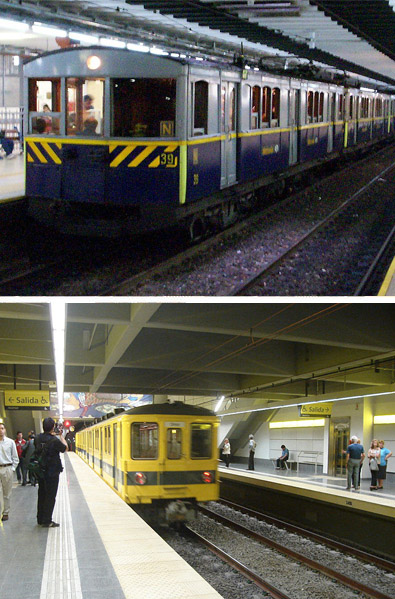
Top: A La Brugeoise car, rolling stock of Line A, at Perú Station.
Bottom: A Line H Orenstein & Koppel – Siemens-Schuckert train set at CaserosInfo Owner Subterráneos de Buenos Aires S.E. (government corporation) Locale Buenos Aires Transit type Rapid transit Number of lines 6 Number of stations 77[1] Daily ridership 1.7 million + 2008 Website www.metrovias.com.ar Operation Began operation 1 December 1913 Operator(s) Metrovías Technical Track gauge 1,435 mm (4 ft 8 1⁄2 in) (standard gauge) System map 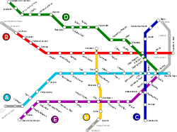
The Buenos Aires Metro (Spanish: Subterráneo de Buenos Aires), locally known as Subte (Spanish pronunciation: [ˈsuβte], from subterráneo – 'underground' or 'subterranean') is a mass-transit system that serves the city of Buenos Aires, Argentina. The first station of this network opened in 1913, the first of its kind in South America, the Southern Hemisphere and the entire Spanish-speaking world. It is one of the busiest metro systems in the world.[2]
The network expanded rapidly during the early decades of the 20th century, but the pace of expansion fell sharply after the Second World War. In the late 1990s expansion resumed, with the planning of four new lines. However, the rate of expansion is largely exceeded by the transportation needs of the city and once again the network has become overcrowded.
At present, Buenos Aires is the only Argentine city with a metro system, but there is a project to build an underground system in the city of Córdoba (Córdoba Metro).[3]
Contents
History
 Vintage line A station entrance on Avenida de Mayo
Discussions on the need to build an underground transportation system in Buenos Aires began in the late nineteenth century, alongside the tramway system. They operated from 1870 and in about 1900 were in a crisis exacerbated by the monopolization of the companies, a process initiated against the electrification of the system.
In this context, the first proposals for the building of an underground system were made, along with requests for government grants: first, in 1886, and several more in 1889, but the Ministry of Interior (Ministerio del Interior, in Spanish) denied the city administration the power to license building in the subsoil of the City. For this reason, subsequent drafts were submitted directly to this ministry.
When in 1894 it was decided to construct the Congress building in its present location, the subway idea was revived, as it might shorten the travel time between the Casa Rosada and the Congress (with the same purpose there were also plans to build an electric aerial tramway to go down the Avenida de Mayo). Miguel Cané, former Mayor of Buenos Aires (1892–1893), also expressed in 1896 the need to build an underground railway similar to the one in London.
But the various projects failed to raise capital due, according to Miguel Cané, "the reluctance of the English to provide the necessary funds for the construction".
The first subway line was opened on 1 December 1913 and was built by the Anglo-Argentine Tramways Company (Compañía de Tranvías Anglo-Argentina (CTAA), in Spanish) , which had been given permission to build in 1909. That line was made up of one of the existing sections of line A, linking the stations of Plaza de Mayo and Plaza Miserere. On 1 April 1914 the line was expand to Río de Janeiro station and on 1 July was extended to Primera Junta Station.
In 1912 the company Lacroze Hermanos won a concession to build another subway line. This line is the current line B and was inaugurated on 17 October 1930. In 1933 the Hispano-Argentina Society of Public Works and Finance (Hispano–Argentina de Obras Públicas y Finanzas (CHADOPYF), in Spanish) began construction of the other subway lines.[4]
The entire network was centralised and nationalised during the late 1930s under the management of the Transport Corporation of Buenos Aires (CTBA), which in 1952 was absorbed by the Buenos Aires Transport General Administration (AGTBA).
In 1963, the administration was dissolved and the subway network became the property of the Subterráneos de Buenos Aires (SBA) company (later SBASE). In 1994 the service was privatised and is now managed by Metrovías S.A. with the stations remaining the property of SBASE.
Timeline
Date Opening(s) Closure 1913-12-01 Plaza de Mayo – Plaza Miserere 1914-04-01 Plaza Miserere – Río de Janeiro 1914-07-01 Río de Janeiro – Primera Junta 1930-10-17 Federico Lacroze – Callao 1931-07-22 Callao – Pellegrini 1931-12 Pellegrini – L.N.Alem 1934-11-09 Constitución – Diagonal Norte 1936-02-06 Diagonal Norte – Retiro 1937-06-03 Catedral – Tribunales 1940-02-23 Tribunales – Palermo 1944-06-20 San José – General Urquiza 1944-12-16 General Urquiza – Boedo (old) 1960-12-09 General Urquiza – Boedo (current) General Urquiza – Boedo (old) 1966-04-24 Boedo (current) – Av. La Plata
San José – Bolívar1973-06-23 Av. La Plata – José María Moreno 1985-10-07 José María Moreno – Emilio Mitre 1985-10-31 Emilio Mitre – Medalla Milagrosa 1985-11-27 Medalla Milagrosa – Varela 1986-05-08 Varela – Plaza de los Virreyes 1987-12-29 Palermo – Ministro Carranza 1997-05-31 Ministro Carranza – José Hernandéz 1999-06-21 José Hernandéz – Juramento 2000-04-27 Juramento – Congreso de Tucumán 2003-08-09 Federico Lacroze – Los Incas 2007-10-18 Once – Caseros 2008-12-23 Primera Junta – Carabobo 2010-12-06 Once – Corrientes 2011-10-04 Caseros – Parque Patricios Current Network
 Former logo of Subterráneos de Buenos Aires
 Humberto Iº station on the new line H
The current[update] network comprises six underground lines, labelled "A" to "E" and "H" and which are further identified by different colours, covering a total track length of 52 km. There is also one surface PreMetro E2 light rail line. Daily ridership is 1.7 million[5] and on the increase. With the current usage patterns, the entire system is overstretched, and during weekdays overcrowded and with insufficient services. An expansion program is planned, and it is expected to enlarge the network to 97 km by 2011.[6]
Fares are cheap (ARS 1.10 (around USD 0.29) and are in fact cheaper than the city buses. While tokens have been used in the past, at present, riders purchase either single-use or multi-use cards (called SubtePass) with a magnetic strip or use Contactless cards called Monedero which can be rechargeable with cash or linked to a bank account for automatic debit. Trains run from 5:00 until 22:45, every 3–6 minutes, depending on the line considered.[citation needed]
Buenos Aires Metro Lines Line Colour Date opening Original path Current termini Length /km Number of stations Daily passengers Line A Light Blue 1913 Plaza de Mayo-Plaza Miserere Plaza de Mayo-Carabobo 8.5 16 190,000 Line B Red 1930 Federico Lacroze-Callao L. N. Alem-de Los Incas/Parque Chas 10.2 15 345,000 Line C Blue 1934 Plaza Constitución-Diagonal Norte Plaza Constitución-Retiro 4.5 9 278,000 Line D Green 1937 Catedral-Tribunales Catedral-Congreso de Tucumán 11.0 16 385,000 Line E Purple 1944 Plaza Constitución-Gral. Urquiza Plaza de los Virreyes-Bolívar 9.6 15 104,000 Line F* Maroon No official opening date Plaza Constitución-Plaza Italia** * 8.6** 13** * Line G* Dark Orange No official opening date Retiro-Cid Campeador** * 7.3** 11** * Line H Yellow 2007 Once-Caseros Corrientes-Parque Patricios 3.4 6 10,000 Line I* Orange No official opening date Plaza Italia-Parque Chacabuco** * 6.6** 9** * * Planned lines ** Law 670 - Anex I.
Stations and connections
Stations are listed from East to West or North to South. Stations in gray have yet to open. Stations in bold are the current termini.

Line AP. de Mayo - Carabobo - Plaza de Mayo
- Perú


- Piedras
- Lima

- Sáenz Peña
- Congreso

- Pasco
- Alberti
- Plaza Miserere

- Loria
- Castro Barros
- Río de Janeiro
- Acoyte
- Primera Junta

- Puan
- Carabobo
- Plaza Flores

- Nazca

Line BLeandro N. Alem - Los Incas - Leandro N. Alem
- Florida
- Carlos Pellegrini
- Uruguay
- Callao
- Pasteur
- Pueyrredón
- Carlos Gardel
- Medrano
- Ángel Gallardo

- Malabia/Osvaldo Pugliese
- Dorrego
- Federico Lacroze
 Urquiza Line
 - Tronador/Villa Ortúzar
- Los Incas/Parque Chas
- Echeverría
- Juan Manuel de Rosas

Line CRetiro - Constitución - Retiro
- General San Martín
- Lavalle
- Diagonal Norte

- Avenida de Mayo

- Moreno
- Independencia
- San Juan
- Constitución

Line DCatedral - C. de Tucumán - Catedral
- 9 de Julio
- Tribunales
- Callao
- Facultad de Medicina
- Pueyrredón
- Agüero
- Bulnes
- Scalabrini Ortiz
- Plaza Italia
- Palermo
- Ministro Carranza
- Olleros
- José Hernández
- Juramento
- Congreso de Tucumán

Line EBolívar - P. de los Virreyes - Retiro
- Catalinas
- Correo Central
- Bolívar
- Belgrano
- Independencia
- San José
- Entre Ríos
- Pichincha
- Jujuy
- General Urquiza
- Boedo
- Avenida La Plata
- José María Moreno
- Emilio Mitre
- Medalla Milagrosa
- Varela
- Plaza de los Virreyes
 PreMetro

Line HCorrientes - Caseros - Corrientes
- Once
- Venezuela
- Humberto I
- Inclán
- Caseros
- Parque Patricios
- Hospitales
Expansion plans
There are several projects to improve connections.[6]
 Lines according to the future expansion program
 New line H and extensions to other lines are under construction
Works in progress
 Line A is under construction towards the west from Carabobo: 2 km with 2 stations: San José de Flores, San Pedrito (previously Nazca) (2010).
 Line B is being extended underground further west (2 km) from Los Incas to Echeverría and Juan Manuel de Rosas where transfer to the Ferrocarril Mitre will be provided.
 Line E extension from Bolívar to Retiro (2 intermediate station C.Central and Catalinas) started mid-2007.
 Line H construction on the section Caseros – Hospitales began in early 2006.
Medium-term projects
Northern section connecting Corrientes to Retiro, has seven stations and is 3.8 km long.New lines planned
The future expansion is based on the program Plan of New Lines:
 ,
,  and
and  , whose routes are already approved by the Legislature of the City. 39.3 km km will be added to the network, expanding it to about 97 km in total length and provide several stations with various interchanges and include north-south routes to create an appropriate network to avoid the city centre. The new lines will mean that more than two million citizens of Buenos Aires, or about 70% of the city's population will live within 400m of a metro station. The new lines will be distributed over 56 new stations. Line F will run from Barracas to Plaza Italia and will include 16 new stations. The planned route length of this line is 10.8 km. Line G will connect Retiro and Villa Park; 12.5 km long with 15 new stations. Construction is expected to start in 2012.[7] Line I will run Parque Chacabuco to Ciudad Universitaria with 18 new stations. The route length is 12.6 km.
Cultural Heritage
 Original sign in Pasco station,
line A Freshly painted vintage line A cars (2009)
 Line A Plaza de Miserere Station platforms, with transfer to the Once station on line H of the underground and rail connections to the Sarmiento suburban line
 View of metro station entrance line C in Retiro Station terminus, with connection to Mitre, Belgrano, and San Martin railway lines
The Buenos Aires Metro has historically been characterized by murals and other artistic works in its stations, making a kind of museum throughout the system. These works, and a number of complete stations, are considered part of the cultural heritage of the city and several of them were declared National Historic Landmarks in 1997.[8]
Line A is world-famous because it still keeps its rolling stock running, making them the oldest subway coaches in commercial service in the world. They were built by La Brugeoise, et Nicaise et Delcuve, a Belgian rolling stock manufacturer established in the city of Bruges, between 1913 and 1919. Entirely made of wood, they were originally designed to run as subway as well as tramway cars, but they were adapted in 1927 to their current styling for underground service only. Since the 1940s, several plans have been made to replace them with newer rolling stock, but none of them has succeeded.[9]
Cultural stations
Many stations are decorated with intricate ceramic tile work, some of it dating back to 1913 when the subway first opened for business. Featured artists include painters and reproductions by Quino, Molina Campos, Raúl Soldi, Rodolfo Medina and Jorge Schwarz. In addition they provide spaces for music and theater events.
- Line B
- Tronador: In this station there are 18 stained glasses that refer to the history of the Villa Ortúzar neighbourhood, were the station is located.
- De los Incas – Parque Chas: In this station there are 16 murals related with different Pre-Columbian era civilizations are exhibited.
- Line C
- San Juan:
- Diagonal Norte: Landscapes of Spain. Ceramic murals that correspond to Burgos, Madrid, Aranjuez, El Escorial and Madrid (Alcalá Door) on South platform, and Avila, Toledo, Soria and Segovia on the North Platform. The drafts were made by Martín S. Noel and Manuel Escasany in 1934.
- General San Martín: Photographic reproductions of the Museo de la Ciudad (City Museum) activities, photographic reproductions and images of the Plaza San Martín (San Martín Park) and photographic reproductions of streets and building of the South zone of the City.
- Congreso de Tucumán:
- Line D
- Juramento: There are a series of murals exposed in this station that had been reproduced in ceramic by Raúl and Daniel De Francisco.
- José Hernández: This station has ceramic reproductions of 4 murals made by Raúl Soldi.
- Olleros: In this station there are showcases exposing works made in the Ceramic School No. 1
- Line H
- Many Hermenegildo Sábat mural reproductions related to tango in all stations.
In popular culture
The subway is featured in the 1996 science fiction film Moebius directed by Gustavo Mosquera. In the film, the circumstances surrounding the disappearance of a metro train are investigated by a topologist. The film is based upon the short story, "A Subway Named Möbius" that takes place in the Boston Subway.[10]
PreMetro light rail
- Main article: PreMetro

The PreMetro line E2 is a light rail system feeding the line E of the Buenos Aires Metro.
Urquiza Line
- Main article: Urquiza Line

Línea Urquiza (in English: Urquiza Line) is a 25.5 km (16 mi) suburban electric commuter line originally designed to be part of the subway system, and operated by the subway operator Metrovías, in Buenos Aires, Argentina. It runs from the Federico Lacroze terminus in the barrio of Chacarita, to General Lemos terminus, Campo de Mayo in Greater Buenos Aires. The line is completely at grade (ground-level) and uses third rail current collection and, at present, is used by an average of 75,400 passengers daily and operates 20 hours a day, 7 days a week at 8 to 30 minute intervals.
In earlier times the line was planned to run into the centre of Buenos Aires through a long tunnel. But when the tunnel was finally built in 1930, it ended up as the B line subway, so that suburban passengers had to change at Federico Lacroze, named after its builder, about 6 km (3.7 mi) from the centre.
See also
- List of Buenos Aires metro stations
- List of metro systems
- List of rapid transit systems
- Metro systems by annual passenger rides
References
- ^ a b "Metrovías en Números". Metrovias. http://www.metrovias.com.ar/V2/MetroviasNumeros.asp?op=11&Item=3&Lang=. Retrieved 2011-08-17.
- ^ Mustafayev, Nicat (29 June 2009). "World metro systems by annual passenger rides". http://en.apa.az/news.php?id=104441. Retrieved 9 July 2009.
- ^ Diario La Voz Del Interior
- ^ www.clico.com.ar Antecedentes, Inicios, Desarrollo de la red y Líneas (Spanish) Retrieved 2010-11-03
- ^ www.rieles.com Subte Récord: Ya transporta 1.7 Millón de pasajeros por día (Spanish) Retrieved 2010-11-12
- ^ a b www.railway-technology.com Buenos Aires Subway Extensions
- ^ "Railway Gazette: Urban rail news in brief". http://www.railwaygazette.com/nc/news/single-view/view/urban-rail-news-in-brief-12.html. Retrieved 2011-05-15.
- ^ Historical National Monuments (Spanish)
- ^ BusARG.ar (Spanish)
- ^ "A subway named Möbius"
External links
- Subterráneos de Buenos Aires (Official Page)
- Metrovías S.A.—Subway Operator (Official Page)
- System map
Buenos Aires Metro ● Line ●● Line ●● Line ●Retiro • General San Martín • Lavalle • Diagonal Norte • Avenida de Mayo • Moreno • Independencia • San Juan • Constitución● Line ●Congreso de Tucumán • Juramento • José Hernández • Olleros • Ministro Carranza • Palermo • Plaza Italia • Scalabrini Ortiz • Bulnes • Agüero • Pueyrredón • Facultad de Medicina • Callao • Tribunales • 9 de Julio • Catedral● Line ●Plaza de los Virreyes • Varela • Medalla Milagrosa • Emilio Mitre • José María Moreno • Avenida La Plata • Boedo • General Urquiza • Jujuy • Pichincha • Entre Ríos • San José • Independencia • Belgrano • Bolívar • Correo Central • Catalinas • Retiro● Line ●Plaza Italia • Salguero • Sánchez de Bustamante • Pueyrredón • Santa Fe • Córdoba • Corrientes • Rivadavia • México • San Juan • Sáenz Peña • Constitución● Line ●Estado de Israel • Gascón • Mario Bravo • Jean Juares • Pueyrredón • Callao • Uruguay • Cerrito • Retiro● Line ●Corrientes • Once • Venezuela • Humberto I • Inclán • Caseros • Parque Patricios • Hospitales● Line ●Serrano • Costa Rica • Córdoba • Corrientes • Warnes • Díaz Vélez • Aranguen • Rivadavia • Pedro Goyena • DirectorioItalics indicates planned stations. Bold indicates stations being constructed.Mass transit systems in Greater Buenos Aires Trains Belgrano Norte Line • Belgrano Sur Line • Mitre Line • Roca Line • San Martín Line • Sarmiento Line • Urquiza LineMetro
(List of stations)Line A • Line B • Line C • Line D • Line E • Line F • Line G • Line H • Line ILight Rails/Trams Buses  Urban public transport networks and systems in Argentina
Commuter rail 
Rapid transit Buenos Aires • Córdoba (planned)Light rail Trams Trolleybuses Córdoba • Mendoza • RosarioCategories:- Buenos Aires Metro
- 1913 establishments in Argentina
- Rail transport in Argentina
- Underground rapid transit in Argentina
- Transport in Buenos Aires


Wikimedia Foundation. 2010.