- Soufrière Hills
-
Not to be confused with Soufrière (volcano) or La Grande Soufrière.
Soufrière Hills 
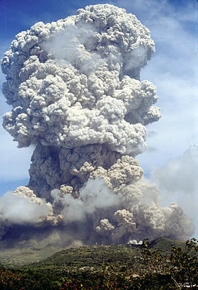
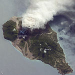
The volcano eruptingElevation 915 m (3,002 ft) [1] Prominence 915 m (3,002 ft) [1] Location Location Montserrat, Caribbean Coordinates 16°43′N 62°11′W / 16.717°N 62.183°WCoordinates: 16°43′N 62°11′W / 16.717°N 62.183°W Geology Type Stratovolcano Volcanic arc/belt Lesser Antilles Volcanic Arc Last eruption 2011  2009 ash and steam plume, Soufriere Hills Volcano. Gray deposits that include pyroclastic flows and volcanic mudflows (lahars) are visible extending from the volcano toward the coastline. NASA ISS photo, 11 October 2009
The Soufrière Hills volcano (French Sulphur Hills) is an active complex stratovolcano with many lava domes forming its summit on the Caribbean island of Montserrat. After a long period of dormancy, it became active in 1995, and has continued to erupt ever since. Its eruptions have rendered more than half of Montserrat uninhabitable, destroying the capital city, Plymouth, and causing widespread evacuations: about two thirds of the population left the island.
The volcano is andesitic in nature and the current pattern of activity includes periods of dome growth, punctuated by brief episodes of dome collapse which result in pyroclastic flows, ash venting, and explosive eruption.
Contents
Eruption Activity
1995–1999
Seismic activity had occurred in 1897–1898, 1933–1937, and again in 1966–1967, but the eruption that began on 18 July 1995 was the first since the 19th century in Montserrat.[2] When pyroclastic flows and mudflows began occurring regularly, Plymouth was evacuated, and a few weeks later a pyroclastic flow covered the city in several metres of debris. The first phreatic explosion in this new period of activity occurred on 21 August 1995, and such activity lasted for 18 weeks until it caused an andesitic lava dome. This was initially confined by a sector-collapse scar. This period lasted for another 60 weeks, after which there were major dome collapses and two periods of explosive Vulcanian eruptions and fountain-collapse pyroclastic flows.[3] It blanketed Plymouth, 6 kilometres (3.7 mi) away in a thick layer of ash and darkened the sky almost completely. Earthquakes continue to occur in three epicentral zones: beneath the Soufrière Hills volcano itself, in the ridge running to the north-east and beneath St George's Hill, about 5 kilometres (3.1 mi) to the north-west.[4] A large eruption on 25 June 1997 resulted in the deaths of nineteen people. The island's airport was directly in the path of the main pyroclastic flow and was completely destroyed.[5] Montserrat's tourist industry was also destroyed. However, it is now regenerating.
The governments of the United Kingdom and Montserrat led the aid effort, including a £41 million package provided to the people of Montserrat; however, riots followed as the people protested that the British Government was not doing enough to aid relief.[6] This had followed at £10 million aid offer by International Development Secretary Claire Short, prompting the resignation of Bertrand Osborne, then Chief Minister of Montserrat after allegations of being too pro-British and not demanding a better offer.[7] The British destroyer HMS Liverpool took a large role in evacuating Montserrat's population to other islands; this included Antigua and Barbuda, who warned they would not be able to cope with many more refugees.[7] About 7,000 people, or two-thirds of the population, left Montserrat; 4,000 to the United Kingdom.[8]
Since 1999
On 24 December 2006, streaks of red from the pyroclastic flows became visible. On 8 January 2007, an evacuation order was issued for areas in the Lower Belham Valley, affecting an additional 100 people.
At 11:27 pm local time on Monday 28 July 2008, an eruption began without any precursory activity. Pyroclastic flow lobes reached Plymouth. These involved juvenile material originating in the collapse of the eruption column. Further, a small part of the eastern side of the lava dome collapsed, generating a pyroclastic flow in Tar River Valley. Several large explosions were registered, with the largest at approximately 11:38 pm. The height of the ash column was estimated at 12,000 m (40,000 ft) above sea level.
The volcano has become one of the most closely monitored volcanoes in the world since its eruption began, with the Montserrat Volcano Observatory taking detailed measurements and reporting on its activity to the government and population of Montserrat. The observatory is operated by the British Geological Survey under contract to the government of Montserrat.
The 9 October 2008 issue of the journal Science suggests that two interconnected magma chambers lie beneath the surface of the volcano on Montserrat – one six kilometers below the surface and the other at 12 kilometers below the surface. They also show a link between surface behavior and the size of the deeper magma chamber.[9][10]
On 5 February 2010, a vulcanian explosion simultaneously propelled pyroclastic flows down several sides of the mountain, and on 11 February 2010, a partial collapse of the lava dome sent large ash clouds over sections of several nearby islands including Guadeloupe and Antigua. Inhabited areas of Montserrat itself received very little ash accumulation through either event.[11]
In popular culture
Soufrière Hills is the namesake of the Jimmy Buffett song "Volcano".[12]
Gallery
See also
- List of settlements abandoned after the 1997 Soufrière Hills eruption
- List of volcanoes in Montserrat
- National Geographic Seconds From Disaster episodes
- Cyclone Xynthia
References
- ^ a b This elevation is for Chance's Peak, the traditional high point. However the lava dome in English's Crater is currently estimated at over 930 m (2006): see The CIA World Factbook on Montserrat.
- ^ "Soufrière Hills". Global Volcanism Program, Smithsonian Institution. http://www.volcano.si.edu/world/volcano.cfm?vnum=1600-05=.
- ^ B. Peter Kokelaar (2002). The eruption of Soufrière Hills volcano, Montserrat, from 1995 to 1999. p. 1. ISBN 9781862390980. http://books.google.co.uk/books?id=kKAPNBu6V_gC&pg=PA1.
- ^ Vi︠a︡cheslav Moiseevich Zobin (2003). "Soufrière Hills volcano, Monserrat (6.2.3.)". Introduction to volcanic seismology. 6. pp. 104–7. ISBN 9780444513403. http://books.google.co.uk/books?id=tnoYgsTTWUgC&pg=PA104.
- ^ "BBC country profile: Montserrat". BBC News. 22 September 2009. http://news.bbc.co.uk/1/hi/world/americas/country_profiles/3666502.stm. Retrieved 2008-03-08.
- ^ "UK citizenship for island outposts". The Guardian (London). 18 March 1999. http://www.guardian.co.uk/uk_news/story/0,,308675,00.html. Retrieved 23 May 2010.
- ^ a b "Montserrat Chief Minister Resigns As People Reject Aid Offer". Politics '97. BBC. http://www.bbc.co.uk/politics97/news/08/0821/montserrat.shtml. Retrieved November 2010.
- ^ "Montserrat evacuation remembered". BBC. 12 September 2005. http://news.bbc.co.uk/1/hi/world/americas/4237882.stm. Retrieved 19 November 2010.
- ^ Elsworth, D; Mattioli, G; Taron, J; Voight, B; Herd, R (October 2008). "Implications of Magma Transfer Between Multiple Reservoirs on Eruption Cycling.". Science 322 (5899): 246–248. doi:10.1126/science.1161297. PMID 18845752. http://www.sciencemag.org/cgi/content/abstract/322/5899/246. Retrieved 2008-10-09.
- ^ Multiple Magma Reservoirs Affect Volcanic Eruption Cycles Newswise, Retrieved on 9 October 2008.
- ^ Montserrat Volcano Observatory
- ^ Jimmy Buffett "Live in Anguilla" CD/DVD.
External links
- Satellite imagery of 11 February 2010 eruption
- Montserrat Volcano Observatory (MVO) - Current monitoring of the Soufrière Hills Volcano in Montserrat.
- USGS Info on Soufrière Hills Volcano
- 2009 activity at Soufrière Hills Volcano, from NASA Earth Observatory
- Photos taken from a passenger jet of an eruption
Categories:- Landforms of Montserrat
- Volcanoes of Montserrat
- Stratovolcanoes
- Active volcanoes
- Mountains and hills of British overseas territories
- Complex volcanoes
Wikimedia Foundation. 2010.


