- Texas State Highway 357
Infobox TX State Highway
type=State
route=357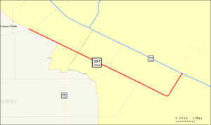
length_mi=11.049
length_ref=TxDOT|SH|357|accessdate=2008-03-12]
length_round=3
formed=1946
dir1=West
dir2=East
from=jct|state=TX|FM|665 in Corpus Christi
junction=jct|state=TX|SH|286 in Corpus Christi
to=jct|state=TX|SH|358 in Corpus Christi
previous_type=State
previous_route=356
next_type=State
next_route=358State Highway 357 or SH 357 is a Texas state highway that runs along the southwestern end of Corpus Christi. The route was designated in 1946, replacing FM 692.
Route description
SH 357 begins in southwestern Corpus Christi at FM 665 and heads towards the southeast along Saratoga Boulevard. As it heads to the southeast, it passes under SH 286 (Crosstown Expressway) at a
diamond interchange . As it heads southeast from the interchange, the highway intersects FM 43 (Weber Road) and FM 2444 (Staples Street). Saratoga Boulevard comes to an end at an intersection with Rodd Field Road. SH 357 follows Rodd Field Road from this intersection to the northeast to its eastern terminus at SH 358 (South Padre Island Drive).cite map|publisher=Google Maps |title=Overview map of SH 357|accessdate=2008-03-12|url=http://maps.google.com/maps?f=d&hl=en&geocode=5421486398606586579,27.736350,-97.488230%3B6782223201167041116,27.679546,-97.371857%3B9542959596405755419,27.692953,-97.341768&saddr=Saratoga+Blvd+%4027.736350,+-97.488230&daddr=Saratoga+Blvd+%4027.679546,+-97.371857+to:Rodd+Field+Rd+%4027.692953,+-97.341768&via=1&doflg=ptm&sll=27.703815,-97.415&sspn=0.079943,0.187111&ie=UTF8&z=13]Junction list
References

Wikimedia Foundation. 2010.