- Mansehra District
-
Mansehra District — District — Location of Mansehra District (highlighted in yellow) within the Khyber Pakhtunkhwa Province.
Country  Pakistan
Province Khyber Pakhtunkhwa Province Capital Mansehra Established Government – District Nazim – District Naib Nazim Area – Total 4,579 km2 (1,768 sq mi) Population (1998) – Total 1,152,839 – Density 272/km2 (704.5/sq mi) Time zone PST (UTC+5) District Council Number of Tehsils 3  Makra Peak
Mansehra District (Urdu: مانسہرہ) is in the Khyber Pakhtunkhwa province of Pakistan, an area still unofficially known as the Northwest Frontier. Mansehra district and town are named after Man Singh, a leading general of Mughal Emperor Akbar. The Kaghan Valley area (a popular tourist destination) and the Karakoram Highway pass through the district.
Contents
History
Alexander the Great and Ashoka

Alexander the Great, after conquering parts of Punjab, established his rule over a large part of Mansehra District. In 327 B.C., Alexander handed this area over to Abisaras (Αβισαρης), the Raja of the Poonch state. Mansehra remained a part of Taxila during the rule of the Maurya dynasty. Ashoka the Great was the Governor of this area when he was a prince. After the death of his father, Bindusara, around 272 B.C., Ashoka inherited the throne and ruled this area as well as Gandhara. Today, the Edicts of Ashoka inscribed on three large boulders on the side of a rocky outcrop near Bareri Hill serve as evidence of his rule here. The Mansehra rocks record fourteen of Ashoka's edicts, presenting aspects of the emperor's dharma or righteous law, and represent the earliest irrefutable evidence of writing in South Asia. Dating to middle of the third century BC, they are written from right to left in the Kharosthi script.[1]
The name Mansehra is a modified form of the name Maan Singh, who once ruled over this area.
The Tanoli territory of Amb State has also been part of Mansehra District, since the State was abolished by the Government of Pakistan in 1969. Amb and its surrounding areas of Hazara have a long history which can be traced to Alexander the Great's invasion of India. Arrian, Alexander's historian, did not indicate the exact location of Embolina, but since it is known that Aoronos was on the right bank of the River Indus, the town chosen to serve as Alexander's base of supplies may with good reason be also looked for there. The mention in Ptolemy's Geography of Embolima as a town of Indo-Scythia situated on the Indus supports this theory.
In 1854 General Abbott, the British frontier officer from whom Abbottabad, administrative centre of Hazara, takes its name, discussed his location of Aornos on the Mahaban range south of Buner. He proposed, as M. Court, one of Ranjit Singh's French generals had done before him in 1839, to recognize Embolima in the present village of Amb situated on the right bank of the Indus. It lies about eight miles to the east of Mahaban and is the place from which the Nawabs of Amb take their title.[2]
Hindu Shahi dynasty and Kashmiris
In the 2nd century CE, a mythical Hindu king Raja Risalu, son of Raja Salbahan of Sialkot, brought the area under his control. The local people consider him as their hero and, even today, parents tell their children the stories of Raja Risalu and his wife Rani Konklan on winter nights. When a Chinese pilgrim, Hiun-Tsang, visited this area, it was under the control of Durlabhavardhana, the ruler of Kashmir.
The Turkish Shahi and Hindu Shahi Dynasties ruled Mansehra one after another. Among the Hindu Shahi dynasty rulers, Raja Jayapala is the best known. Mehmood of Ghazni defeated Raja Jayapala during his first Indian campaign. However, there is no historical evidence that Mehmood of Ghazni ever visited or passed through Mansehra. After the fall of Hindu Shahi dynasty, in the 11th century, the Kashmiris took control of this area under the leadership of Kalashan (1063 to 1089). From 1112 to 1120, King Susala ruled this area. In the 12th century, Asalat Khan captured this area but soon after Mohammad of Ghor's death the Kashmiris once again regained control of Mansehra.
Turkish rule
In 1399, the great Muslim warrior Timur, on his return to Kabul, stationed his Turk soldiers in Manshera to protect the important route between Kabul and Kashmir. By 1472, Prince Shahab-ud-Din came from Kabul and established his rule over the region. Prince Shahab-ud-Din, a Turk of central Asian origin, founded the state and named it Pakhli Sarkar and chose Village Gulibagh as his capital. During the Mughal rule, these local Turkish chiefs acknowledged Mughal authority. In fact, Mansehra (Pakhli) provided the main route to Kashmir and was the most commonly used route for Emperor Akbar to travel to Kashmir. During the last days of Emperor Akbar's rule, the Turkish Chief Sultan Hussain Khan revolted against the Mughals. He claimed that the Mughals were interfering with his internal affairs. After this complaint, he was exiled by the Mughals, but later was pardoned and given back his land. Now, descendants of these Turkish rulers live in village Behali and some other villages of Mansehra, Abbottabad, and Haripur districts.
 Akbar as a boy around 1557
Afghan rule
Turkish rule came to an end due to the increased aggression of the Pashtuns and their allied forces. In 1703, the Turks came under attack by the Swatis under the leadership of Syed Jalal Baba, who was son in law of last Turkish ruler of Hazara, (Sultan Memud Khurd) took benefit of absence of his father in law and with the help of Swaties succeeded to overthrow the Turks from the throne of Pakhli Sarkar.The Turks were pushed towards the mountainous areas of Tanawel (Behali) and other parts of Hazara, including Haripur (Manakrai). The Turks remained in control of certain small areas, assuming the title of Raja. Raja Amanulla of Manakrai, Haripur, one of the descendants of the Turkish rulers of Hazara, rose to prominence during post-independence era, when he became the Speaker of the Khyber-Pakhtunkhwa assembly in 1985.
When Ahmad Shah Durrani expanded his kingdom to Punjab, Mansehra also came under his control. Durrani considered it wise to rule the area through local tribal chiefs. The Durranis' rule ended abruptly at the beginning of the 18th century.
Tanoli rule
The Tanolis had already established their authority over Tannawal and thus Tannawal was never annexed by the Durranis. The voluminous Urdu copy of the settlement report of Hazara compiled by Major Wace in 1872 contains many passages in its historical resume of the area. In a number of maps drawn at the time and enclosed in the report, showing Hazara under the Mughals and under the Durranis, the Amb state has been shown as Mulk-i-Tanawal. The original existence of that Mulk is as old as the middle period of the great Afghan invasions of India. Their leader Nawab Khan (Father of Painda Khan) never accepted the Durrani Rule and used to heavily tax the Durrani caravans which passed through the Mulk-e-Tanawal. He defeated the Durranis in battle but met his death at the hands of Sardar Azim Khan Durrani in 1818, who invited him to his camp and killed him by treachery. Upper Tanawal (mostly now in present day District Mansehra) and Lower Tanawal (mostly now in present day district Haripur), covering the greater part of Hazara, have been ruled by Tanolis for centuries.
The fall of the Durranis led way for the Sikhs to rise to power under Ranjit Singh. The Sikhs gained control of Mansehra in 1818, after stiff resistance from its inhabitants. When Mansehra fell under Sikh control, it was annexed to Punjab. Syed Ahmad Shaheed, with the help of the Mujaheddin, led many revolts and attacks against the Sikhs. At last, in 1831 during a fierce battle at Balakot, Syed Ahmad Shaheed was killed. This allowed the Sikhs to consolidate their control of Mansehra. After Rajit Singh's death, the Sikh empire began to disintegrate. At this time, the British gained control of Punjab, and, through this, gained control of Mansehra.
Painda Khan Tanoli was the tribal chief of the Tanolis at the time of the invasion of Hazara by the Sikhs. Painda Khan is famed for his staunch rebellion against Maharaja Ranjit Singh's Governors of Hazara. From about 1813, he spent a life long rebellion against the Sikhs. Painda Khan's relentless rebellion against the Sikh empire, cost him a major portion of his Kingdom, leaving only his twin capitals Amb and Darband. However, this deterred him less and appeared to increase his resistance against the Sikh government.
Painda Khan son Jehandad Khan also followed the footsteps of his famed father. "Of all the tribal chiefs of Hazara, the most powerful said to be Jehandad Khan of the Tanoli, whose land straddled both banks of the Indus and whose fellow-tribesmen were 'brave and hardy and accounted for the best swordsmen in Hazara'.[3]
When Sikh power was on the fall in 1845 Jehandad Khan blockaded the garrisons of no less than 22 Sikh posts in Upper Tanawal; and when they surrendered at discretion, he spared their lives, as the servants of a fallen Empire.[4]
In the meantime other Chiefs of Hazara rushed to arms to exterminate the Sikhs who were in their country. They invited Syud Akbur, of Sitana (after wards king of Swat), to come over and be King of Hazara, and make a holy war with them. Nawab Khan of Thingri, became Syad Akbur's "Wazir", Pir Khan came down to join with the Jaduns, Khan i Zeman brought the Tarkheylies; the Swatis of Publi, and the Mushwanis, swelled the tumult. For two months they besieged Diwan Mulraj, the Kardar, in the fort of Hurkishengarh; and at last, after several gallant repulses, reduced the garrison to evacuate by cutting off the water.[5]
On 19 March 1846, a peace treaty was signed between the Sikhs and the British according to which Raja Gulab Singh took Kashmir and Hazara from the British for 75,00,000 rupees. But due to widespread civil disorder and resistance movement Raja asked the British government to take over Hazara in exchange of the Jamu-Jehlum belt. The British accepted this offer and took over Hazara from him. They deputed James Abbot to Hazara to restore peace. He defeated Chuttar Singh, a Sikh general, after coming to Hazara and thus completely ousted the Sikhs from power.
British rule
By 1849, the British had gained control of all of Mansehra. However, the western Pashtun tribes remained rebellious. These tribes included the clans of Allai Valley and Nandhiar Valley, and the tribes inhabiting both slopes of the Black Mountain of Hazara.
In 1852, after three years of relative peace, Zaman Shah of Kaghan turned against the British. James Abbot sent an expedition to Kaghan which deprived Zaman Shah of his territory and he was exiled to Pakhli plain. After four years the British forgave him and he was permitted to get back his lost territory.
However, the British sent many expeditions against the Pashtun tribes to crush the rebellion between 1852 and 1892, especially against the Black Mountains.
To maintain peace in the area the British also took preventive measures by co-opting the local rulers.
The British divided Hazara District into three Tehsils (administrative subdivisions): Mansehra, Abbottabad, and Haripur; and decided to annex it to the Punjab. In 1901, when the North West Frontier Province (NWFP) (now Khyber-Pakhtunkhwa) was created, Hazara was separated from Punjab and made a part of it. Throughout their rule in Mansehra, the British met fierce resistance from the local Pashtun tribes and declared martial law. Meanwhile, the people of Mansehra's many villages largely governed themselves. Many of Mansehra's citizens joined the Khilafat Movement.
The British accepted the independence of the Nawab of Amb; within his own territory and thus no writ of the British Government, civil or criminal, was ever enacted within the Tanoli State of Amb. The smaller Tanoli State of Phulra, which was granted by Painda Khan to his brother Madad Khan, was also acknowledged by the Britishers as a semi-independent Princely State. Thus the British Government agreed not to meddle with the affairs of the Tanoli territory of Hazara, with the mutual understanding that the Tanolis would not attack the British controlled territories.
When the Muslim League in Pakistan started its movement for a separate land, the local people joined and struggled for liberation under the leadership of Quaid-i-Azam.[citation needed] Their eventual victory culminated in the creation of Pakistan, an independent state for the Muslims of the sub-continent.
Nawab Sir Muhammad Zakir Khan (K.B.E) of the Amb State had very good relations with Malik Hussain and Nawabzada Moiz khan. His contributions to the Pakistan movement have been acknowledged by letters from Quaid-i-Azam.[6][7] In 1947 the Nawab of Amb, Mohammad Farid Khan, acceded to Pakistan by signing the Instrument of Accession of his State, in favour of Pakistan. In 1969, the State was incorporated into the Khyber Pakhtunkhwa Province and in 1971 the royal status of the Nawab was abolished by the Government of Pakistan.
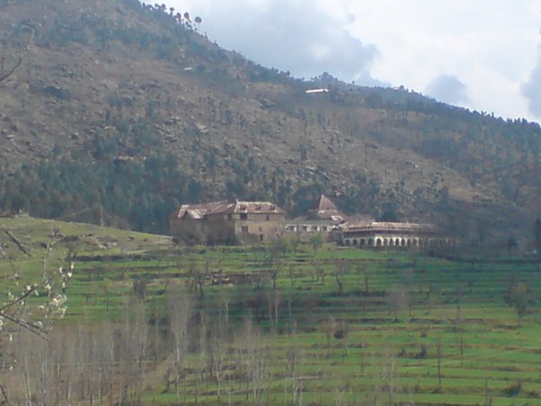
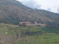 Shergarh Fort, summer residence, Nawab of Amb
During Bhutto's regime, Mansehra was upgraded to a district, containing two subdivisions: Mansehra and Batagram. Later, the Mansehra district had the Balakot subdivision added to it.
Geography
Mansehra is located at the eastern border of the Khyber Pakhtunkhwa Province, two hours away from Peshawar and three hours away from Islamabad. The district is located at 34° - 12' and 35° - 50' and 47° - 07' longitude. It is closely linked to Afghanistan in the west, which has increased the number of Afghan refugees in Mansehra over the past years.
The district of Mansehra has been blessed with wonderful scenery. Some of Mansehra's main features are mountain ranges, plains, valleys, and numerous lakes and rivers.
Bordering districts
Mansehra shares its borders with numerous other districts: the Kohistan and Diamir districts to the north, Abbottabad District to the south, the Neelum District of Azad Kashmir to the west, and the Swat district to the east and Batagram District to the northeast.
Lakes
There are three lakes in the district: Lulusar Lake, Dudipatsar Lake and Saiful Muluk Lake. All three are located in the beautiful Kaghan Valley and act as a mirror reflecting the snow-clad mountains surrounding them.
Lulusar Lake is approximately 48 kilometres away from Naran and has an altitude of 3325 meters. Surrounded by wildflowers in almost all colours imaginable, this lake is the main source for the Kunhar River. Lake Lulusar is said to be one of the most tranquil spots on the Kaghan Valley, the lake is fenced by snowcapped mountains whose image is reflected on the standstill blue-green waters of the lake.
Dudipat Lake is enclosed with beautiful, high, snow-drizzled peaks, it is one of the hardest places to reach, requiring a tough hike lasting four to seven hours. The hike is rewarding, as tourists are greeted with green pastures and the lake's blue-green waters.
The most famous of the district's many lakes is Lake Saiful Muluk, named in a folktale—the Qissa Saiful Muluk—about a romance between a Persian prince and a fairy princess. In the folktale, the lake was the meeting site for the two lovers. Lake Saiful Muluk is located at the northern end of the Kaghan valley. At an altitude of 10,578 feet (3,224 m) above sea level, it is one of the highest lakes in Pakistan. The water is spectacularly clear with a slight green tone. It is accessible by a jeep road during the summer months or can be hiked up from the village below in four to six hours. The clarity of the water comes from the multiple glaciers all around the high basin feeding the lake.
Education
Mansehra is considered a good place for education because of its natural beauty and climate, it is the location of Hazara University and also contains colleges and many good schools. The first primary school in the district was established in 1872 in Behali village. Almost at the same time in Baffa and in 1892 in Mansehra city.
Rivers
The largest river is the Kunhar River, also known as the Kunnar (not to be confused with the Kunar River of the Chitral District). The river is the gateway to the Kaghan Valley and runs through Balakot. Siran is a largest river in the area of Pakhhal it comes from mountain namely Musa Da Masalla and ends in the lake of Tarbela Dam.
Administration
Subdivisions
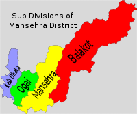 Administrative subdivisions of Mansehra District.
The district consists of three tehsils, which are divided into 59 Union Councils,[8] and two Provincially Administered Tribal Areas (PATA):
- Balakot
- Mansehra
- Oghi
- Kala Dhaka
- Upper Tanawal area of Hazara Division
Balakot
Balakot Tehsil consists of 16 Union Councils:
Mansehra
Mansehra Tehsil consists of 33 Union Councils:
- Hilkot
- Icherrian
- Inayat Abad
- Jaborri
- Jaloo
- Labarkot
- Lassan Nawab
- Lassan Thakral
- Malik Pur
- Mansehra City No 1
- Mansehra City No 2
- Mansehra City No 3
- Mansehra City No 4
- Mansehra (Rural)
- Perhinna
- Phulrraa
- Morbuffa Klan
- Mangloor
- Khawari
- Jankiary
- Morbuffa Khurd
- Bandi
- Blahag Bala
- Blahag Pain
- Shaeylia
- Sacha Kalan
- Shinkiari
- Shoukatabad
- Sum Alahi Mong
- Swan Miara
- Tanda
- Trangi Sabir Shah
- Panjool Nawazabad
Oghi
Tehsil Oghi consists of 11 Union Councils:
Constituencies
The district is represented in the provincial assembly by six elected MPAs who represent the following constituencies:[9]
- PF-53 (Mansehra-1)
- PF-54 (Mansehra-2)
- PF-55 (Mansehra-3)
- PF-56 (Mansehra-4)
- PF-57 (Mansehra-5)
- PF-58 (Mansehra-6)
Demographics
Mansehra is home to a diverse group of people: Swatis, Abbasi Gujjars, Syeds, Awans, Rajputs, Kashmiris, Maliars, Yousufzais, Tanolis, Hassanzai, Qureshi, Karlugh Turks, Afghan refugees and many other ethnic groups. Its population in 1998 was 1,152,839.[10]
References
- ^ UNESCO world heritage Centre - Mansehra Rock Edicts
- ^ On Alexander's Track to the Indus By Aurel Stein, Published by B. Blom, 1972, Original from the University of Michigan, Digitized 2 Sep 2008, 182 pages
- ^ Allen 2001, p. 139.
- ^ In a letter dated; Peshawar, 10th December 1858, from Lt.Col. H. B. Edwards, Commissioner and Supdt, Peshawar Division, to the Financial Commissioner of the Punjab. extracted from 'A Collection of Papers relating to the History, Status and Powers of The Nawab of Amb, pg 83, Published 1874, Punjab Secretariat
- ^ letter dated 21st March 1863. From Thomas Douglas Forsyth, Officiating Secretary to the Government Punjab to Secretary to the Government of India, Foreign Department, Collection of Papers Relating To The History, Status and Powers of the Chief of Amb, 97 Pages, Published 1874, Punjab Secretariat, pg 58
- ^ Quaid-I-Azam Mohammad Ali Jinnah Papers: First Series, Volume III: On the Threshold of Pakistan, July 1–25, 1947 By Mahomed Ali Jinnah, Z. H. Zaidi Contributor Z. H. Zaidi Edition: illustrated Published by Oxford University Press, 1997 Original from the University of Michigan Digitized 29 Aug 2008 ISBN 969-8156-07-0, 9789698156077 1120 pages
- ^ Frontier of faith: Islam in the Indo-Afghan borderland By Sana Haroon Edition: illustrated Published by Columbia University Press, 2008 ISBN 0-231-70013-X, 9780231700139 254 pages
- ^ Tehsils & Unions in the District of Mansehra - Government of Pakistan
- ^ Constituencies and MPAs - Website of the Provincial Assembly of Khyber-Pakhtunkhwa
- ^ 1998 Census of Pakistan
Districts of Khyber Pakhtunkhwa 

Union councils Atter Shisha · Badi Shungli · Baffa · Balakot · Battal · Behali · Belian · Bherkund · Bhogerr Mong · Chater Plain · Darband · Datta · Devli Jaberr · Dhodial · Dilborri · Garhi Habibullah · Garlat · Ghanool · Hamsherian · Hangrai · Hilkot · Icherrian · Inayat Abad · Jaborri · Jaloo · Kaghan · Karnol · Karorri · Kathai · Kewal · Laber Kot · Lassan Nawab · Lassan Thakral · Malik Pur · Mansehra City No 1 · Mansehra City No 2 · Mansehra City No 3 · Mansehra(Rural) · Mohandri · Nika Pani · Oghi · Pairan · Perhinna · Phulrraa · Sacha Kalan · Sandasar · Satbani · Shamdarra · Shohal Mazullah · Shoukatabad · Sum Alahi Mong · Swan Miara · Talhata · Tanda · Trangi Sabir ShahCategories:- Mansehra District
- Districts of Khyber Pakhtunkhwa


Wikimedia Foundation. 2010.