- Santa Clara County, California
-
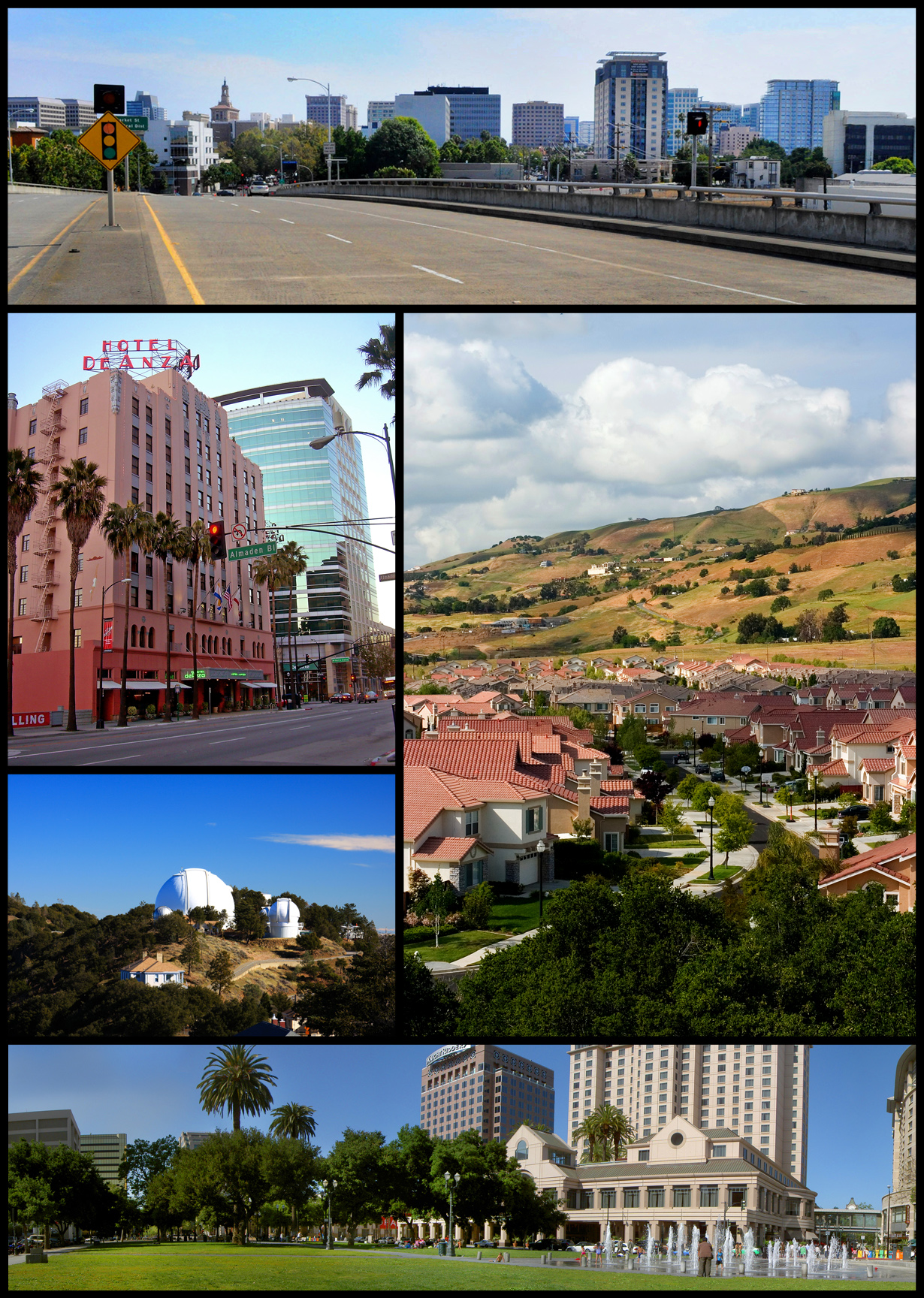
County of Santa Clara — County — Images, from top, left to right: Downtown San Jose, San Jose Museum of Art, De Anza Hotel, San Jose.

SealLocation in the state of California
Country  United States
State  California
Region/Metro Area San Francisco Bay Area Incorporated 1850 Named for Mission Santa Clara de Asís
St. Clare of AssisiCounty seat San Jose Largest City San Jose Area - Total 3,377.4 km2 (1,304.01 sq mi) - Land 3,342.9 km2 (1,290.69 sq mi) - Water 34.5 km2 (13.325 sq mi) Population (2010) - Total 1,781,642 - Density 527.5/km2 (1,366.3/sq mi) Time zone Pacific Standard Time (UTC-8) - Summer (DST) Pacific Daylight Time (UTC-7) Area code(s) 408, 650 Website www.sccgov.org Santa Clara County is a county located at the southern end of the San Francisco Bay Area in the U.S. state of California. As of 2010 it had a population of 1,781,642. The county seat is San Jose. The highly urbanized Santa Clara Valley within Santa Clara County is also known as Silicon Valley. Santa Clara is the most populous county in the Bay Area region, and one of the most affluent counties in the United States.
Contents
History
Main article: History of Santa Clara County, CaliforniaSanta Clara County was one of the original counties of California, formed in 1850 at the time of statehood. The original inhabitants included the Ohlone, residing on Coyote Creek and Calaveras Creek. Part of the county's territory was given to Alameda County in 1853.
The county is named after Mission Santa Clara, which was established in 1777, and named for Saint Clare of Assisi, Italy.
In 1882, Santa Clara County tried to levy taxes upon property of the Southern Pacific Railroad within county boundaries. The result was the U.S. Supreme Court case of Santa Clara County v. Southern Pacific Railroad, 118 U.S. 394 (1886), in which the Court extended Due Process rights to artificial legal entities.
After two centuries of an agricultural economy started by the Spanish missionaries, the focus has shifted to technology. This trend is not new. Hewlett Packard was founded in 1939, and IBM selected San Jose as its West Coast headquarters in 1943. Varian Associates, Fairchild Semiconductor, and other early innovators, were located in the county by the late 1940s and 1950s. The U.S. Navy had a large presence in the area and began giving large contracts to Silicon Valley electronics companies. The term "Silicon Valley" was coined in 1971. The trend accelerated in the 1980s and 1990s, as agriculture has been nearly eliminated from the northern part of the county. Today, Santa Clara County is the headquarters for such companies as Apple, Facebook, Sun Microsystems, Hewlett Packard, Google, Yahoo, eBay, Intel and many others. Most of Silicon Valley's (Santa Clara Valley) high tech companies are located within the county, with some adjoining tech regions in San Mateo, Alameda, and Santa Cruz counties also being considered Silicon Valley.
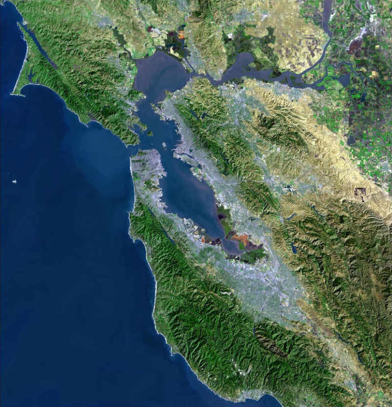
Geography
According to the 2000 census, the county has a total area of 1,304.01 square miles (3,377.4 km2), of which 1,290.69 square miles (3,342.9 km2) (or 98.98%) is land and 13.32 square miles (34.5 km2) (or 1.02%) is water.[1]
The San Andreas Fault runs along the Santa Cruz Mountains in the south of the county.
Cities, towns, and neighborhoods
Incorporated cities and towns
There are 15 incorporated cities and towns in the county:
- San Jose, which includes all or portions of the former cities/communities of:
- Alum Rock,
- Cambrian Park,
- Willow Glen,
- East San Jose, and
- Alviso
- Campbell
- Cupertino
- Gilroy
- Los Altos
- Los Altos Hills
- Los Gatos
- Milpitas
- Monte Sereno
- Morgan Hill
- Mountain View
- Palo Alto
- Santa Clara
- Saratoga
- Sunnyvale
Unincorporated communities
Census-designated places
- Alum Rock
- Burbank
- Cambrian Park
- East Foothills
- Fruitdale
- Lexington Hills
- Loyola also known as Loyola Corners
- San Martin
- Stanford
Other unincorporated communities
- Bell Station also known as Bell's Station and Hollenbeck's Station.
- Casa Loma also known as Loma Chiquita.
- Chemeketa Park (part of Lexington Hills CDP)
- Coyote also known as Burnett circa 1860–1882.
- Redwood Estates (part of Lexington Hills CDP)
- Rucker
- San Antonio also known as Deforest circa 1892–1924.
Former townships
- Almaden Township: Present-day Almaden Valley, Cambrian Park and portions of Campbell and Los Gatos.
- Alviso Township: Present-day Alviso.
- Burnett Township: Present-day Coyote, Santa Teresa and Morgan Hill.
- Fremont Township: Present-day Palo Alto, Sunnyvale, Mountain View, Los Altos, Los Altos Hills and part of Cupertino.
- Gilroy Township: Present-day Gilroy and San Martin.
- Milpitas Township: Present-day Milpitas.
- Redwood Township: Present-day Los Gatos, Monte Sereno, Saratoga, Redwood Estates and portions of Cupertino and Campbell.
- San Jose Township: Most of present-day San Jose.
- Santa Clara Township: Present-day Santa Clara and portions of San Jose, Cupertino and Campbell.
Adjacent counties
- San Benito County, California—south
- Santa Cruz County, California—south, southwest
- San Mateo County, California—northwest
- Alameda County, California—north
- Stanislaus County, California—east
- Merced County, California—southeast

San Mateo County Alameda County 
Stanislaus County  Santa Clara County, California

Santa Cruz County San Benito County and Santa Cruz County Merced County National protected area
Transportation infrastructure
Freeways and expressways
The county has an extensive freeway system and a separate expressway system. Expressways in California are distinct from freeways; although access to adjoining properties is eliminated, at-grade intersections are allowed. However, unlike expressways virtually everywhere else in California, the Santa Clara County expressways were built, signed, and maintained as county roads; they are not maintained by Caltrans, although they are patrolled by the California Highway Patrol.
There is also a large street network dominated by four- and six-lane arterials. Some of the newer boulevards (primarily in the West Valley) are divided with landscaped medians.
Major highways
Main article: State highways in CaliforniaCounty routes
See also: List of county routes in California- Santa Clara County Expressway System
 Santa Clara County Route G2—Lawrence Expressway
 Santa Clara County Route G3—Page Mill Road/Oregon Expressway
 Santa Clara County Route G4—San Tomas Expressway/Montague Expressway
 Santa Clara County Route G5—Foothill Expressway
 Santa Clara County Route G6—Central Expressway
 Santa Clara County Route G8—Almaden Expressway
 Santa Clara County Route G10—Blossom Hill Road
 Santa Clara County Route G21—Capitol Expressway
Other roads
- The Alameda
Mass transit
Santa Clara County has consolidated its transportation services into the Santa Clara Valley Transportation Authority, which operates a rapidly expanding light rail system and a large system of bus routes. It also manages certain county-funded highway and expressway projects.
Besides SCVTA, the County is also served by Caltrain commuter rail service, and the ACE Train system, which runs between San Jose and Stockton.
County Bicycle Network
The Santa Clara Valley Transportation Authority is establishing a bicycle network throughout the county. Santa Clara County Bicycle network is part of the San Francisco Bay Area, Regional Bikeway Network.
Ports
The county's main airport is Norman Y. Mineta San José International Airport (SJC). It is a U.S. Customs and Border Protection port of entry.[2] San Francisco International Airport, is also often used by residents of Santa Clara County. Moffett Federal Airfield (NUQ), a former U.S. Naval Air Station, is used by the Air National Guard, NASA, Lockheed Martin, Google, and by the San Jose Police and Santa Clara County Sheriff's Department as an air operations base.[3] There are also smaller general aviation airports in Palo Alto (PAO), San Jose (RHV), and San Martin (E16).
The county has no commercial seaports, although small boats can access San Francisco Bay from several points. Like many other Bay Area counties, it is dependent upon the Port of Oakland for transport of ocean cargo.
Demographics
Historical populations Census Pop. %± 1860 11,912 — 1870 26,246 120.3% 1880 35,039 33.5% 1890 48,005 37.0% 1900 60,216 25.4% 1910 83,539 38.7% 1920 100,676 20.5% 1930 145,118 44.1% 1940 174,949 20.6% 1950 290,547 66.1% 1960 642,315 121.1% 1970 1,064,714 65.8% 1980 1,295,071 21.6% 1990 1,497,577 15.6% 2000 1,682,585 12.4% 2010 1,781,642 5.9% 2000
As of the census[4] of 2000, there are 1,682,585 people, 565,863 households, and 395,538 families residing in the county. The population density is 503/km² (1,304/mi²). There are 579,329 housing units at an average density of 173/km² (449/mi²). The racial makeup of the county is 53.83% White, 2.80% Black or African American, 0.67% Native American, 25.56% Asian, 0.34% Pacific Islander, 12.13% from other races, and 4.66% from two or more races. 23.98% of the population are Hispanic or Latino of any race.
There were 565,863 households out of which 34.9% had children under the age of 18 living with them, 54.9% were married couples living together, 10.0% had a female householder with no husband present, and 30.1% were non-families. 21.4% of all households were made up of individuals and 5.9% had someone living alone who was 65 years of age or older. The average household size was 2.92 and the average family size was 3.41.
In the county the population was spread out with 24.7% under the age of 18, 9.3% from 18 to 24, 35.4% from 25 to 44, 21.0% from 45 to 64, and 9.5% who were 65 years of age or older. The median age was 34 years. For every 100 females there were 102.80 males. For every 100 females age 18 and over, there were 101.90 males.
The median income for a household in the county was $74,335, and the median income for a family was $81,717. Males had a median income of $56,240 versus $40,574 for females. The per capita income for the county was $32,795. About 4.9% of families and 7.5% of the population were below the poverty line, including 8.4% of those under age 18 and 6.4% of those age 65 or over.
As of 2011, Santa Clara County has the second-highest median household income of any county in California, the highest being Marin County.
2010
The 2010 United States Census reported that Santa Clara County had a population of 1,781,642. The racial makeup of Santa Clara County was 836,616 (47.0%) White, 46,428 (2.6%) African American, 12,960 (0.7%) Native American, 570,524 (32.0%) Asian, 7,060 (0.4%) Pacific Islander, 220,806 (12.4%) from other races, and 87,248 (4.9%) from two or more races. Hispanic or Latino of any race were 479,210 persons (26.9%).[5]
Population reported at 2010 United States Census The County Total
PopulationWhite African
AmericanNative
AmericanAsian Pacific
Islanderother
racestwo or
more racesHispanic
or Latino
(of any race)Santa Clara County 1,781,642 836,616 46,428 12,960 570,524 7,060 220,806 87,248 479,210 Incorporated
cities and townsTotal
PopulationWhite African
AmericanNative
AmericanAsian Pacific
Islanderother
racestwo or
more racesHispanic
or Latino
(of any race)Campbell 39,349 26,315 1,158 275 6,320 161 2,713 2,407 7,247 Cupertino 58,302 18,270 344 117 36,895 54 670 1,952 2,113 Gilroy 48,821 28,674 942 831 3,448 111 12,322 2,493 28,214 Los Altos 28,976 20,459 148 48 6,815 59 195 1,252 1,132 Los Altos Hills 7,922 5,417 37 4 2,109 8 50 297 213 Los Gatos 29,413 24,060 269 86 3,203 52 462 1,281 2,120 Milpitas 66,790 13,725 1,969 309 41,536 346 5,811 3,094 11,240 Monte Sereno 3,341 2,698 14 12 464 0 28 125 162 Morgan Hill 37,882 24,713 746 335 3,852 125 5,779 2,332 12,863 Mountain View 74,066 41,468 1,629 344 19,232 391 7,241 3,761 16,071 Palo Alto 64,403 41,359 1,197 121 17,461 142 1,426 2,697 3,974 San Jose 945,942 404,437 30,242 8,297 303,138 4,017 148,749 47,062 313,636 Santa Clara 116,468 52,359 3,154 579 43,889 651 9,624 6,212 22,589 Saratoga 29,926 16,125 94 41 12,376 23 202 1,065 1,034 Sunnyvale 140,081 60,193 2,735 662 57,320 638 12,177 6,356 26,517 Census-designated
placesTotal
PopulationWhite African
AmericanNative
AmericanAsian Pacific
Islanderother
racestwo or
more racesHispanic
or Latino
(of any race)Alum Rock 15,536 6,581 207 298 2,039 70 5,466 875 10,977 Burbank 4,926 2,994 135 64 379 16 1,049 289 2,509 Cambrian Park 3,282 2,598 26 29 221 19 190 199 591 East Foothills 8,269 4,853 205 78 1,445 41 1,219 428 3,118 Fruitdale 935 633 31 11 110 4 88 58 244 Lexington Hills 2,421 2,148 10 5 90 0 59 109 193 Loyola 3,261 2,291 19 1 760 2 37 151 114 San Martin 7,027 4,329 27 71 470 18 1,752 360 3,249 Stanford 13,809 7,932 651 86 3,777 28 263 1,072 1,439 Unincorporated
communitiesTotal
PopulationWhite African
AmericanNative
AmericanAsian Pacific
Islanderother
racestwo or
more racesHispanic
or Latino
(of any race)All others not CDPs (combined) 30,494 21,985 439 256 3,175 84 3,234 1,321 7,651 Libraries
Santa Clara County Library, is a public library system serving the communities and cities of Campbell, Cupertino, Gilroy, Los Altos, Los Altos Hills, Milpitas, Monte Sereno, Morgan Hill, Saratoga, and all unincorporated areas of the county.[6]
Government and politics
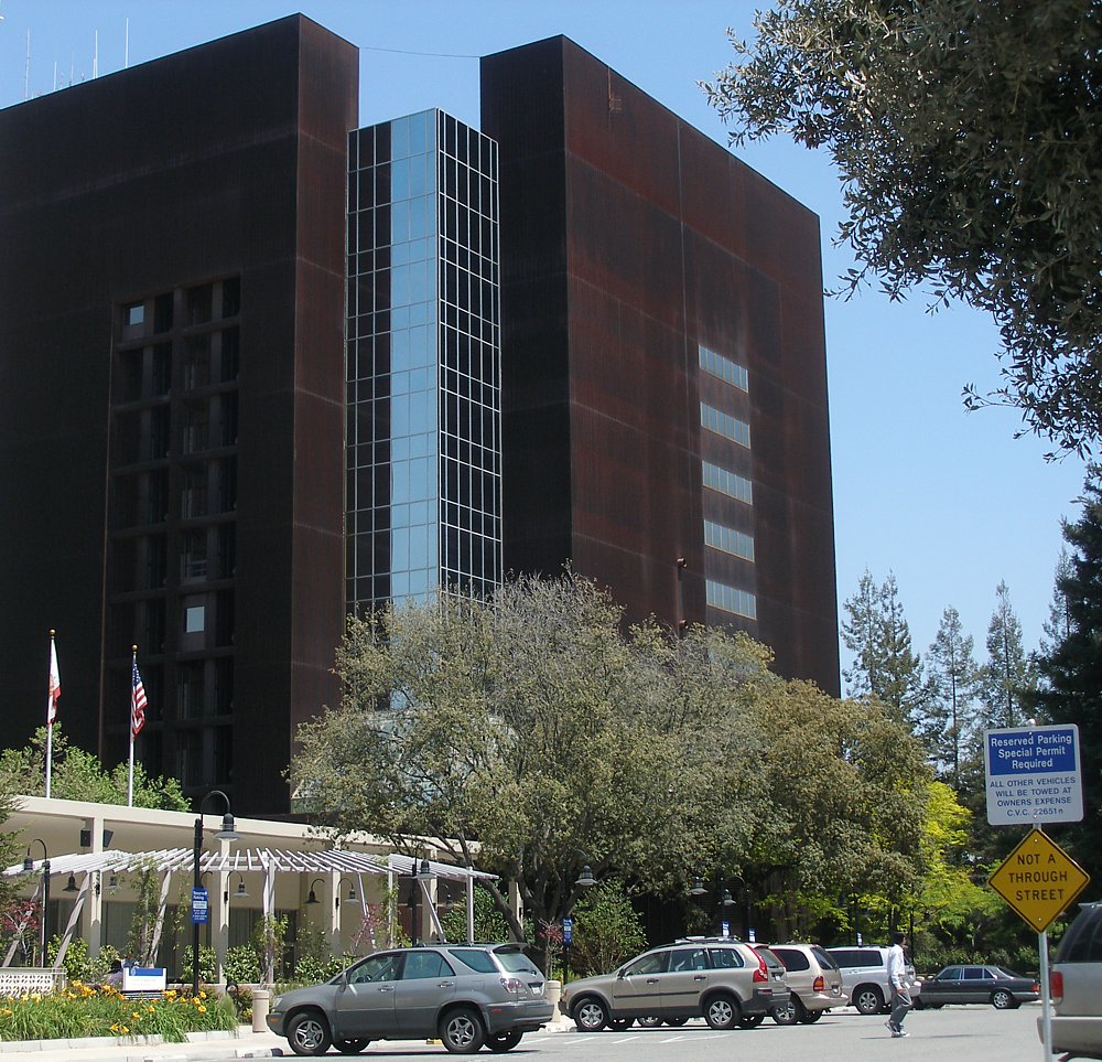
 Santa Clara County Government Center
Santa Clara County vote
by party in presidential electionsYear GOP DEM Others 2008 28.6% 190,039 69.5% 462,241 1.8% 12,255 2004 34.6% 209,094 63.9% 386,100 1.4% 8,622 2000 34.4% 188,750 60.7% 332,490 4.9% 26,889 1996 32.2% 168,291 56.9% 297,639 11.0% 57,361 1992 28.4% 170,870 49.2% 296,265 22.4% 134,920 1988 47.0% 254,442 51.3% 277,810 1.7% 9,276 1984 54.8% 288,638 43.7% 229,865 1.5% 8,136 1980 48.0% 229,048 35.0% 166,995 17.0% 80,960 1976 49.5% 219,188 46.9% 208,023 3.6% 15,927 1972 51.9% 237,334 45.6% 208,506 2.5% 11,453 1968 45.6% 163,446 48.4% 173,511 6.0% 21,410 1964 36.6% 117,420 63.1% 202,249 0.3% 858 1960 52.7% 131,735 47.1% 117,667 0.3% 690 1956 59.1% 105,657 40.6% 72,528 0.4% 633 1952 59.7% 91,940 39.7% 61,035 0.6% 932 1948 53.3% 52,982 42.1% 41,905 4.6% 4,615 1944 47.0% 39,409 52.4% 43,869 0.6% 499 1940 49.2% 40,100 49.6% 40,449 1.2% 947 1936 40.4% 26,498 58.5% 38,346 1.1% 732 1932 47.5% 27,353 49.1% 28,272 3.3% 1,906 1928 63.8% 31,710 35.4% 17,589 0.8% 395 1924 58.0% 20,056 7.4% 2,560 34.6% 11,952 1920 68.1% 19,565 22.6% 6,485 9.1% 2,682 Santa Clara County has five elected Supervisors, elected within their districts.
Santa Clara is a strongly Democratic county in presidential and congressional elections. The last Republican to win a majority in the county was Ronald Reagan in 1984. With the exceptions of Los Altos Hills, Monte Sereno, and Saratoga, all of the cities, towns, and the unincorporated areas of Santa Clara County have more registered Democrats than Republicans.[7] In the 2008 US Presidential Election, Democratic nominee Barack Obama carried every city and town in the county, as well as the unincorporated areas.[8]
In the House of Representatives, all of California’s 15th and 16th districts, as well as some of the 11th and 14th districts, are in the county and are all held by Democrats: Jerry McNerney in the 11th, Anna Eshoo in the 14th, Mike Honda in the 15th, and Zoe Lofgren in the 16th.
In the State Assembly, all of the 22nd, 23rd, and 24th districts, as well as parts of the 20th, 21st, 27th, and 28th districts are in the county. The districts are all held by Democrats; in order of district number they are Bob Wieckowski, Rich Gordon, Paul Fong, Nora Campos, Jim Beall, Bill Monning, and Anna Caballero.
In the State Senate, all of the 13th as well as parts of the 10th, 11th, and 15th districts are in the county. The 10th, 11th, and 13th districts are held by Democrats, Ellen Corbett, Joe Simitian, and Elaine Alquist, respectively. The 15th is held by Republican Sam Blakeslee.
Following the passage of Proposition 8, Santa Clara County joined San Francisco and Los Angeles in a lawsuit, becoming, along with San Francisco and Los Angeles, the first governmental entities in the world to sue for same sex marriage.[9] The county is among one of three counties in California to establish a separate department to deal with corrections pursuant to California Government Code §23013, the Santa Clara County Department of Corrections, along with Napa County and Madera County.
Parks
Santa Clara County has an extensive park system, much of it founded in the major park expansion of the late 1970s. Some of the parks within the county are:
Open space preserves include:
- El Sereno Open Space Preserve
Sister counties
To promote friendship and understanding and to build bridges with countries of origin for various ethnic populations in the county, the County of Santa Clara has created a Sister County Commission to coordinate the program. As of 2009, there are three sister counties:[10]
See also
- Santa Clara Valley
- List of attractions in Silicon Valley
- List of California public officials charged with crimes, Santa Clara County
- Committee for Green Foothills
- Old Almaden Winery
- Santa Clara County expressway system
- List of school districts in Santa Clara County, California
- National Register of Historic Places listings in Santa Clara County, California
References
- ^ "Census 2000 U.S. Gazetteer Files: Counties". United States Census. http://www.census.gov/tiger/tms/gazetteer/county2k.txt. Retrieved 2011-02-13.
- ^ http://www.cbp.gov/xp/cgov/toolbox/contacts/ports/ca/2834.xml
- ^ Verne Kopytoff (September 13, 2007). "Google founders pay NASA $1.3 million to land at Moffett Airfield". San Francisco Chronicle. http://sfgate.com/cgi-bin/article.cgi?f=/c/a/2007/09/13/BUPRS4MHA.DTL&tsp=1. Retrieved 2007-09-23.
- ^ "American FactFinder". United States Census Bureau. http://factfinder.census.gov. Retrieved 2008-01-31.
- ^ "2010 Census P.L. 94-171 Summary File Data". United States Census Bureau. http://www2.census.gov/census_2010/01-Redistricting_File--PL_94-171/California/.
- ^ "Contact Us." Santa Clara County Library. Retrieved on March 27, 2010.
- ^ http://www.sos.ca.gov/elections/ror/ror-pages/15day-presgen-08/politicalsub.pdf
- ^ http://www.sos.ca.gov/elections/sov/2008_general/ssov/5-pres-by-political-districts.pdf
- ^ "Herrera Joined by Los Angeles, Santa Clara Counterparts in Suing to Invalidate Prop 8". Office of the City Attorney of San Francisco. 2008-11-05. http://news.lp.findlaw.com/hdocs/docs/election2008/20081105-sf-la-prop8-petition.pdf. Retrieved 2008-12-20.
- ^ "Sister County Commissions (PRG)". The County of Santa Clara. http://www.sccgov.org/portal/site/sistercountycomm/. Retrieved 2010-01-07.
External links
- Santa Clara Valley Water District - Drinking Water
- Santa Clara County official website
- Santa Clara County governmental committee agendas
- Santa Clara County Planning Office
- List of special districts in Santa Clara County (LAFCo)
- Santa Clara County Library
- Santa Clara County: California's Historic Silicon Valley, a National Park Service Discover Our Shared Heritage Travel Itinerary
Coordinates: 37°22′N 121°58′W / 37.36°N 121.97°W
Municipalities and communities of Santa Clara County, California County seat: San Jose Cities and towns Campbell | Cupertino | Gilroy | Los Altos | Los Altos Hills | Los Gatos | Milpitas | Monte Sereno | Morgan Hill | Mountain View | Palo Alto | San Jose | Santa Clara | Saratoga | Sunnyvale

CDPs Alum Rock | Burbank | Cambrian Park | East Foothills | Fruitdale | Lexington Hills | Loyola | San Martin | Stanford
Unincorporated
communitiesBell Station | Casa Loma | Chemeketa Park | Coyote | Holy City | Loma Chiquita | Old Gilroy | New Almaden | Redwood Estates | Rucker | San Antonio Valley | Sargent | Sveadal
Ghost towns San Francisco Bay Area Bodies of water Bodega Bay · Carquinez Strait · Clifton Forebay · Golden Gate · Grizzly Bay · Guadalupe River · Half Moon Bay · Lake Berryessa · Napa River · Oakland Estuary · Petaluma River · Richardson Bay · Richmond Inner Harbor · Russian River · San Francisco Bay · San Leandro Bay · San Pablo Bay · Sonoma Creek · Suisun Bay · Tomales Bay

Counties Alameda · Contra Costa · Marin · Napa · San Francisco · San Mateo · Santa Clara · Solano · Sonoma
Major cities Cities and towns
100k–250kCities and towns
25k–99kAlameda · Belmont · Benicia · Brentwood · Burlingame · Campbell · Castro Valley · Cupertino · Danville · Dublin · East Palo Alto · Foster City · Gilroy · Livermore · Los Altos · Los Gatos · Martinez · Menlo Park · Milpitas · Morgan Hill · Mountain View · Napa · Newark · Novato · Oakley · Pacifica · Palo Alto · Petaluma · Pittsburg · Pleasant Hill · Pleasanton · Redwood City · Rohnert Park · San Bruno · San Carlos · San Leandro · San Mateo · San Pablo · San Rafael · San Ramon · Saratoga · South San Francisco · Suisun City · Union City · Vacaville · Walnut Creek · Windsor
Cities and towns
5k–25kAlamo · Albany · Alum Rock · American Canyon · Ashland · Atherton · Bay Point · Blackhawk-Camino Tassajara · Cherryland · Clayton · Discovery Bay · Dixon · El Cerrito · El Sobrante · Emeryville · Fairview · Half Moon Bay · Healdsburg · Hercules · Hillsborough · Lafayette · Larkspur · Los Altos Hills · Millbrae · Mill Valley · Moraga · North Fair Oaks · Orinda · Piedmont · Pinole · San Anselmo · San Lorenzo · Sonoma · Stanford · Tamalpais-Homestead Valley
Sub-regions  State of California
Sacramento (capital) Topics Climate · Delegations · Deserts · Districts · Ecology · Elections · Environment · Geography · Government · History · Protected areas · Sports · Symbols · Transportation · Visitor attractions · Index of California-related articles
Society Californians · Culture · Crime · Demographics · Economy · Education · Politics
Regions Antelope Valley · Big Sur · Cascade Range · Central California · Central Coast · Central Valley · Channel Islands · Coachella Valley · Conejo Valley · Cucamonga Valley · Death Valley · East Bay (SF) · East County (SD) · Eastern California · Emerald Triangle · Gold Country · Great Basin · Greater Los Angeles · Greater Sacramento · Inland Empire · Lake Tahoe · Los Angeles Basin · Lost Coast · Metropolitan Fresno · Mojave · Mountain Empire · North Bay (SF) · North Coast · North County (SD) · Northern California · Owens Valley · Oxnard Plain · San Francisco Peninsula · Pomona Valley · Sacramento Valley · San Bernardino Valley · San Diego–Tijuana · San Fernando Valley · San Francisco Bay Area · San Gabriel Valley · San Joaquin Valley · Santa Clara Valley · Santa Clara River Valley · Santa Clarita Valley · Shasta Cascade · Sierra Nevada · Silicon Valley · South Bay (LA) · South Bay (SF) · South Bay (SD) · South Coast · Southern California · Southern Border Region · Tri-Valley · Upstate California · Victor Valley · Wine Country · Yosemite
Metro areas Bakersfield · Chico · El Centro · Fresno · Hanford–Corcoran · Los Angeles–Long Beach–Glendale · Madera · Modesto · Merced · Napa · Oakland–Fremont–Hayward · Oxnard–Thousand Oaks–Ventura · Redding · Riverside–San Bernardino–Ontario · Sacramento–Arden Arcade–Roseville · Salinas · San Diego–Carlsbad–San Marcos · San Francisco–San Mateo–Redwood City · San Jose–Sunnyvale–Santa Clara · San Luis Obispo–Paso Robles · Santa Ana–Anaheim–Irvine · Santa Barbara–Santa Maria–Goleta · Santa Cruz–Watsonville · Santa Rosa–Petaluma · Stockton · Vallejo–Fairfield · Visalia–Porterville · Yuba City
Micro areas Counties Alameda · Alpine · Amador · Butte · Calaveras · Colusa · Contra Costa · Del Norte · El Dorado · Fresno · Glenn · Humboldt · Imperial · Inyo · Kern · Kings · Lake · Lassen · Los Angeles · Madera · Marin · Mariposa · Mendocino · Merced · Modoc · Mono · Monterey · Napa · Nevada · Orange · Placer · Plumas · Riverside · Sacramento · San Benito · San Bernardino · San Diego · San Francisco · San Joaquin · San Luis Obispo · San Mateo · Santa Barbara · Santa Clara · Santa Cruz · Shasta · Sierra · Siskiyou · Solano · Sonoma · Stanislaus · Sutter · Tehama · Trinity · Tulare · Tuolumne · Ventura · Yolo · Yuba
Categories:- Santa Clara County, California
- Counties in the San Francisco Bay Area
- California counties
- San Jose, which includes all or portions of the former cities/communities of:


Wikimedia Foundation. 2010.