- Tulare County, California
-
County of Tulare
Garden of the Sun— County — 
SealTulare County's location in California California's location in the United States
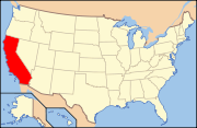
Country  United States
State  California
Region Central California Metro area Visalia Metropolitan Area Incorporated 1852 Named for Tulare Lake County seat Visalia Incorporated cities 8 Government – County Administrative Officer Jean Rousseau – Board of Supervisors SupervisorsArea – Total 12,533.2 km2 (4,839.09 sq mi) – Land 12,494 km2 (4,823.97 sq mi) – Water 39.2 km2 (15.12 sq mi) Highest elevation[1] 4,421 m (14,505 ft) Population (2010) – Total 442,179 – Density 35.3/km2 (91.4/sq mi) Time zone Pacific Standard Time (UTC-8) – Summer (DST) Pacific Daylight Time (UTC-7) Area code(s) 559 Website co.tulare.ca.us Tulare County is a county located in the Central Valley of the U.S. state of California, south of Fresno. Sequoia National Park is located in the county, as are part of Kings Canyon National Park, in its northeast corner (shared with Fresno County), and part of Mount Whitney, on its eastern border (shared with Inyo County). As of the 2010 census, the population was 442,179, up from 368,021 at the 2000 census. Its county seat is Visalia.
The county is named for Tulare Lake, once the largest freshwater lake west of the Great Lakes. Drained for agricultural development, the site is now in Kings County, which was created in 1893 from the western portion of the formerly larger Tulare County.
Contents
History
The land was occupied for thousands of years by varying cultures of indigenous peoples. Beginning in the seventeenth century, Spain established missions to colonize the area and convert the American Indians to Christianity. Comandante Pedro Fages, while hunting for deserters in 1772, discovered a great lake surrounded by marshes and filled with rushes; he named it Los Tules (the tules). It is from this lake that the county derives its name. The root of the name Tulare is found in the Mexican word tullin, designating cattail or similar reeds.
After Mexico achieved independence, it continued to rule California. The United States defeated Mexico in 1848, and European Americans formed Tulare County from parts of Mariposa County in 1852. Parts of the county's territory were given to Fresno County in 1856, to Kern County in 1866, to Inyo County in 1866 and Kings County in 1893.
The infectious disease Tularemia caused by the bacterium Francisella tularensis is named after Tulare County.
In 1908 Colonel Allen Allensworth and associates founded Allensworth as a black farming community. They intended to develop a place where African Americans could thrive free of white discrimination. It was the only community in California founded, financed and governed by African Americans. While its first years were highly successful, the community encountered environmental problems from dropping water tables which eventually caused it to fail. Today the historic area is preserved as the Colonel Allensworth State Historic Park, which is listed on the National Register of Historic Places.
Economy
The dairy industry, with sales of milk products, brings in the most revenue for the county, typically more than US$ 1 billion a year annually. Oranges, grapes, and cattle-related commodities also earn hundreds of millions of dollars annually.
In 2001, Tulare became the most productive county in the U.S. in terms of agricultural revenues, at US$ 3.5 billion annually. It surpassed Fresno County's US$ 3.2 billion, which had held the top spot for over two decades. Due to the importance of agriculture in the county as well as its location in the state, since 1968 the city of Tulare has been the site of the annual World Ag Expo,[2] the world's largest agricultural exposition.
Minor league sports teams, such as the baseball Visalia Rawhide of the class-A level California League (an affiliate to the Arizona Diamondbacks), two teams of the Minor League Football Association in Tulare and Visalia, and four teams of the Central California Basketball League based in Porterville, attract many residents and add to the amenities in the county.[citation needed]
Top employers
According to the County's 2010 Comprehensive Annual Financial Report[3], the top employers in the county are:
# Employer # of Employees 1 County of Tulare 4,320 2 Porterville Developmental Center 3,000 3 Kaweah Delta Medical Center 2,000 4 Ruiz Foods 1,800 5 Wal-Mart 1,692 6 College of the Sequoias 1,160 7 Cigna 900 8 Jostens 720 9 Land O'Lakes 600 10 Monrovia Nursery 600 Geography
According to the 2000 census, the county has a total area of 4,839.09 square miles (12,533.2 km2), of which 4,823.97 square miles (12,494.0 km2) (or 99.69%) is land and 15.12 square miles (39.2 km2) (or 0.31%) is water.[4]
Cities, towns, and unincorporated communities
- Incorporated cities
- Census-designated places (CDPs)
- Allensworth
- Alpaugh
- California Hot Springs
- Camp Nelson
- Cedar Slope
- Cutler
- Delft Colony
- Ducor
- Earlimart
- East Orosi
- East Porterville
- East Tulare Villa
- El Rancho
- Goshen
- Hartland
- Idlewild
- Ivanhoe
- Kennedy Meadows
- Lemon Cove
- Lindcove
- Linnell Camp
- London
- Matheny
- McClenney Tract
- Monson
- Orosi
- Panorama Heights
- Patterson Tract
- Pierpoint
- Pine Flat
- Pixley
- Plainview
- Ponderosa
- Poplar-Cotton Center
- Posey
- Poso Park
- Richgrove
- Rodriguez Camp
- Sequoia Crest
- Seville
- Silver City
- Springville
- Strathmore
- Sugarloaf Mountain Park
- Sugarloaf Saw Mill
- Sugarloaf Village
- Sultana
- Terra Bella
- Teviston
- Three Rivers
- Tipton
- Tonyville
- Tooleville
- Traver
- Waukena
- West Goshen
- Wilsonia
- Woodville
- Yettem
- Other unincorporated communities
- Advance
- Angiola
- Badger
- Balance Rock
- Cairns Corner
- Calgro
- Johnsondale
- Kaweah
- Rocky Hill
- White River
- Yokohl Ranch, California (proposed town)
- Yokohl Valley
- Zante
- Indian reservations
- Tule River Indian Reservation
Adjacent counties
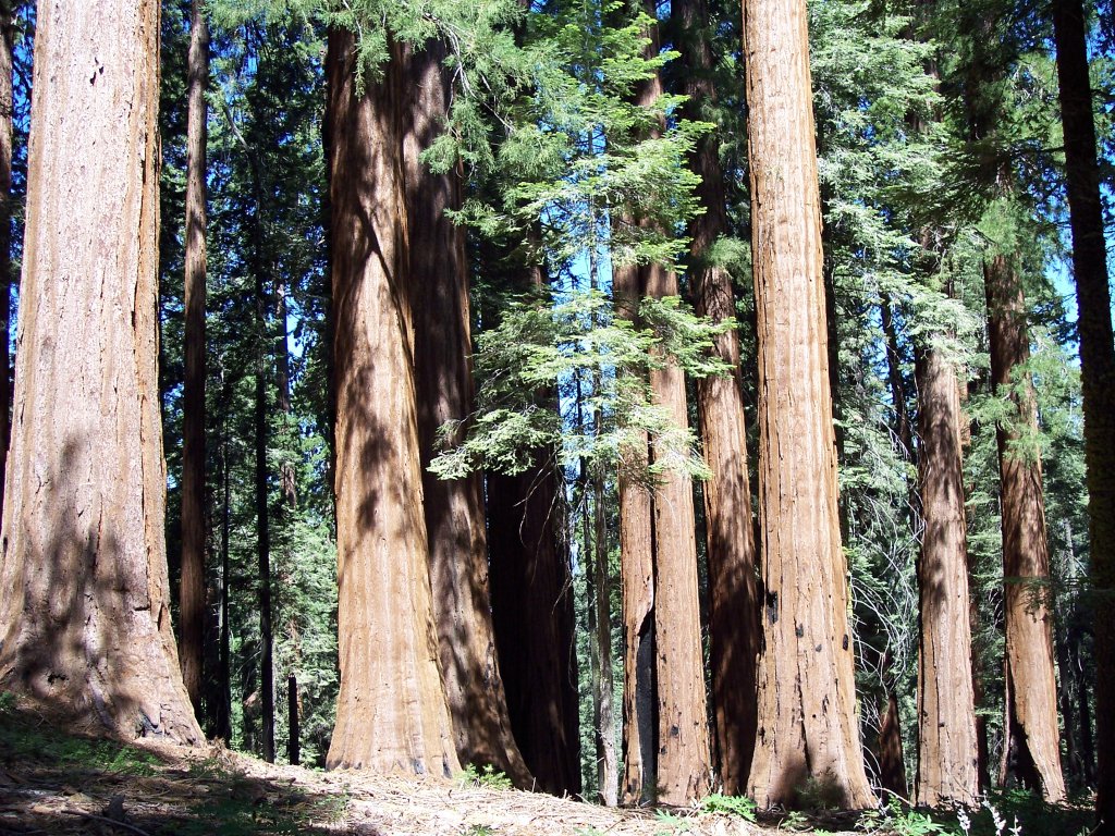
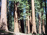 Sequoia National Park is located within Tulare County.
- Fresno County - north
- Inyo County - east
- Kern County - south
- Kings County - west
National protected areas
- Blue Ridge National Wildlife Refuge
- Giant Sequoia National Monument (part)
- Inyo National Forest (part)
- Kings Canyon National Park (part)
- Pixley National Wildlife Refuge
- Sequoia National Forest (part)
- Sequoia National Park
Transportation infrastructure
Major highways
Public transportation
Tulare County Transit provides a countywide bus service linking the population centers. A connection to Delano in Kern County is also operated.
The cities of Tulare, Porterville, and Visalia have their own local bus services.
Greyhound and Orange Belt Stages provide long-distance, intercity bus service.
Airports
The Visalia Municipal Airport has very limited commercial passenger service. Sequoia Field, just north of Visalia, is a county-owned general aviation airport. Mefford Field is a city-owned general aviation airport located in Tulare.
The nearest full operation commercial airports are Bakersfield's Meadows Field Airport to the South, and Fresno's Fresno Yosemite International Airport to the North.
Demographics
2010
The 2010 United States Census reported that Tulare County had a population of 442,179. The racial makeup of Tulare County was 265,618 (60.1%) White, 7,196 (1.6%) African American, 6,993 (1.6%) Native American, 15,176 (3.4%) Asian, 509 (0.1%) Pacific Islander, 128,263 (29.0%) from other races, and 18,424 (4.2%) from two or more races. Hispanic or Latino of any race were 268,065 persons (60.6%).[5]
Population reported at 2010 United States Census The County Total
PopulationWhite African
AmericanNative
AmericanAsian Pacific
Islanderother
racestwo or
more racesHispanic
or Latino
(of any race)Tulare County 442,179 265,618 7,196 6,993 15,176 509 128,263 18,424 268,065 Incorporated
citiesTotal
PopulationWhite African
AmericanNative
AmericanAsian Pacific
Islanderother
racestwo or
more racesHispanic
or Latino
(of any race)Dinuba 21,453 11,166 141 193 454 17 8,630 852 18,114 Exeter 10,334 7,150 67 171 138 8 2,416 384 4,703 Farmersville 10,588 5,295 60 213 72 5 4,494 449 8,876 Lindsay 11,768 6,480 85 128 267 4 4,367 437 10,056 Porterville 54,165 31,847 673 1,007 2,521 64 15,482 2,571 33,549 Tulare 59,278 36,347 2,328 694 1,276 80 15,713 2,840 34,062 Visalia 124,442 80,203 2,627 1,730 6,768 164 27,249 5,701 57,262 Woodlake 7,279 3,691 37 108 52 9 3,072 310 6,381 Census-designated
placesTotal
PopulationWhite African
AmericanNative
AmericanAsian Pacific
Islanderother
racestwo or
more racesHispanic
or Latino
(of any race)Allensworth 471 158 22 0 8 0 279 4 436 Alpaugh 1,026 381 4 11 4 0 597 29 867 California Hot Springs 37 34 0 0 1 0 0 2 3 Camp Nelson 97 94 0 0 0 0 2 1 6 Cedar Slope 0 0 0 0 0 0 0 0 0 Cutler 5,000 2,421 50 53 64 1 2,241 170 4,829 Delft Colony 454 213 13 0 0 0 224 4 428 Ducor 612 251 0 15 20 0 302 24 502 Earlimart 8,537 3,193 67 45 536 0 4,303 393 7,805 East Orosi 495 209 0 5 2 1 261 17 466 East Porterville 6,767 3,660 65 153 102 58 2,431 298 4,930 East Tulare Villa 778 491 9 6 10 0 226 36 428 El Rancho 124 71 1 1 0 0 49 2 117 Goshen 3,006 1,186 76 90 11 1 1,496 146 2,482 Hartland 30 27 3 0 0 0 0 0 0 Idlewild 43 43 0 0 0 0 0 0 0 Ivanhoe 4,495 2,002 19 80 29 1 2,221 143 3,752 Kennedy Meadows 28 25 0 1 0 0 2 0 3 Lemon Cove 308 261 0 5 3 2 12 25 76 Lindcove 406 284 2 15 0 0 96 9 197 Linnell Camp 849 397 3 18 8 0 393 30 832 London 1,869 761 6 46 0 0 976 80 1,737 Matheny 1,212 651 44 24 4 0 436 53 890 McClenney Tract 10 9 0 0 0 0 0 1 0 Monson 188 121 1 5 4 0 57 0 147 Orosi 8,770 3,861 65 57 803 1 3,638 345 7,606 Panorama Heights 41 35 1 1 0 0 4 0 4 Patterson Tract 1,752 999 0 33 73 0 577 70 1,133 Pierpoint 52 51 0 0 0 0 1 0 1 Pine Flat 166 158 0 3 3 0 0 2 11 Pixley 3,310 1,473 90 28 16 0 1,587 116 2,675 Plainview 945 358 8 20 2 0 517 40 865 Ponderosa 16 13 0 0 0 0 1 2 4 Poplar-Cotton Center 2,470 1,729 1 15 356 0 327 42 1,809 Posey 10 6 0 3 0 0 0 1 3 Poso Park 9 9 0 0 0 0 0 0 0 Richgrove 2,882 1,068 20 38 140 7 1,521 88 2,705 Rodriguez Camp 156 51 0 0 0 0 98 7 151 Sequoia Crest 10 10 0 0 0 0 0 0 0 Seville 480 200 0 5 0 0 259 16 458 Silver City 0 0 0 0 0 0 0 0 0 Springville 934 836 5 20 7 0 25 41 109 Strathmore 2,819 1,490 12 41 7 1 1,162 106 2,238 Sugarloaf Mountain Park 0 0 0 0 0 0 0 0 0 Sugarloaf Saw Mill 18 14 0 0 0 0 1 3 4 Sugarloaf Village 10 9 0 0 0 0 0 1 2 Sultana 775 315 0 3 6 0 424 27 695 Terra Bella 3,310 1,426 5 20 75 2 1,733 49 2,894 Teviston 1,214 449 50 9 10 0 640 56 1,039 Three Rivers 2,182 1,976 7 27 31 1 75 65 212 Tipton 2,543 1,535 3 15 9 0 924 57 2,147 Tonyville 316 178 0 0 12 0 115 11 286 Tooleville 339 145 5 19 8 2 148 12 279 Traver 713 302 1 22 6 2 357 23 551 Waukena 108 86 0 3 0 0 19 0 45 West Goshen 511 276 2 10 7 0 195 21 358 Wilsonia 5 5 0 0 0 0 0 0 0 Woodville 1,740 1,345 1 31 6 0 324 33 1,545 Yettem 211 48 5 0 0 0 148 10 199 Unincorporated
communitiesTotal
PopulationWhite African
AmericanNative
AmericanAsian Pacific
Islanderother
racestwo or
more racesHispanic
or Latino
(of any race)All others not CDPs (combined) 67,213 46,040 512 1,753 1,245 78 15,416 2,169 34,101 2000
As of the census[6] of 2000, there were 368,021 people, 110,385 households, and 87,093 families residing in the county. The population density was 76 people per square mile (29/km²). There were 119,639 housing units at an average density of 25 per square mile (10/km²). The racial makeup of the county was 58.08% White, 1.59% Black or African American, 1.56% Native American, 3.27% Asian, 0.11% Pacific Islander, 30.79% from other races, and 4.60% from two or more races. 50.77% of the population were Hispanic or Latino of any race. 6.2% were of American, 5.7% German and 5.0% English ancestry according to Census 2000. 56.3% spoke English, 38.9% Spanish and 1.1% Portuguese as their first language.
There were 110,385 households out of which 44.9% had children under the age of 18 living with them, 58.1% were married couples living together, 14.5% had a female householder with no husband present, and 21.1% were non-families. 17.1% of all households were made up of individuals and 7.7% had someone living alone who was 65 years of age or older. The average household size was 3.28 and the average family size was 3.67.
In the county the population was spread out with 33.8% under the age of 18, 10.6% from 18 to 24, 27.6% from 25 to 44, 18.2% from 45 to 64, and 9.8% who were 65 years of age or older. The median age was 29 years. For every 100 females there were 100.0 males. For every 100 females age 18 and over, there were 97.7 males.
The median income for a household in the county was $33,983, and the median income for a family was $36,297. Males had a median income of $30,892 versus $24,589 for females. The per capita income for the county was $14,006. About 18.8% of families and 23.9% of the population were below the poverty line, including 32.6% of those under age 18 and 10.5% of those age 65 or over.
Crime statistics
(reported by the sheriff's office or county police)[7]
- Murders: 3
- Rapes: 40
- Robberies: 87
- Assaults: 411
- Burglaries: 1328
- Thefts: 2117
- Auto thefts: 11
Politics
Tulare County vote
by party in presidential electionsYear GOP DEM Others 2008 56.9% 59,765 41.5% 43,634 2.0% 2,126 2004 66.2% 65,399 32.9% 32,494 1.0% 967 2000 60.2% 54,070 36.8% 33,006 3.1% 2,742 1996 53.9% 46,272 38.1% 32,669 8.1% 6,905 1992 45.7% 40,482 35.2% 31,188 19.1% 16,883 1988 59.6% 46,891 39.0% 30,711 1.4% 1,067 1984 63.9% 51,066 35.1% 28,065 1.0% 812 1980 58.3% 41,317 35.5% 25,155 6.2% 4,374 1976 54.5% 31,864 43.7% 25,551 1.8% 1,027 1972 59.9% 36,048 36.2% 21,775 3.9% 2,327 1968 52.2% 29,314 39.5% 22,180 8.4% 4,695 1964 39.8% 22,527 60.1% 33,974 0.1% 51 1960 54.0% 29,456 45.6% 24,887 0.4% 239 1956 52.5% 26,051 47.2% 23,407 0.3% 160 1952 57.1% 30,108 42.1% 22,208 0.8% 437 1948 47.0% 18,414 50.2% 19,681 2.8% 1,097 1944 49.3% 16,005 50.0% 16,221 0.7% 238 1940 42.9% 15,414 56.0% 20,129 1.2% 428 1936 30.8% 8,624 67.7% 18,956 1.6% 435 1932 32.3% 8,066 62.5% 15,631 5.2% 1,302 1928 63.8% 12,057 35.1% 6,635 1.2% 218 1924 50.8% 9,484 18.3% 3,425 30.9% 5,765 1920 61.3% 9,136 32.4% 4,837 6.3% 941 Tulare is a strongly Republican county in Presidential and congressional elections. The last Democratic candidate for President to win a majority in the county was Lyndon Johnson in 1964.
Tulare is part of California's 21st congressional district, which is held by Republican Devin Nunes. In the State Assembly, Tulare is in the 29th, 30th, 31st, and 34th districts. The 31st is held by Independent Henry Perea, while the 29th, 30th, and 34th are held by Republicans Linda Halderman, Danny Gilmore, and Connie Conway, respectively. In the State Senate, Tulare is part of the 16th and 18th districts, which are held by Democrat Michael Rubio and Republican Jean Fuller respectively.
Lakes
- Columbine Lake
- Crescent Lake
- Franklin Lakes
- Rockslide Lake
- Lake Kaweah
- Weaver Lake
- Arctic Lake
- Bullfrog Lakes
- Rocky Basin Lakes
- Lake Success
Rivers
- Angora River
- St. John's River
- Yokohl River
- Yucca River
- Alpine River
- Needlerock River
- Monarch River
- Monache River
- Negro River
- Tule River
Parks
- Pixley National Wildlife Refuge
- Lake Kaweah Recreation Area
- Allensworth Historic District
- Balch Park
- Cutler Park
- Woodville Park
- West Main Street Park
- Mooney Grove Park / Ancient Oak Forest Preserve
- Sequoia National Park
- Horse Creek Recreation Area
- Lackeys Cabin
- Mineral King Game Refuge
- Alpaugh Park
- Kings River Nature Preserve
- Bartlett Park
Sequoia National Park
Main article: Sequoia National ParkSequoia National Park is a national park in the southern Sierra Nevada, east of Visalia, California, in the United States of America. It was established in 1890 as the second U.S. national park, after Yellowstone National Park. The park spans 404,051 acres (1,635.14 km2). Encompassing a vertical relief of nearly 13,000 feet (3,962 m), the park contains among its natural resources the highest point in the contiguous 48 United States, Mount Whitney, at 14,505 feet (4,421 m) above sea level. The park is south of and contiguous with Kings Canyon National Park; the two are administered by the National Park Service as one unit, called Sequoia and Kings Canyon National Parks.
Clemmie Gill School Of Science And Conservation
Clemmie Gill School Of Science And Conservation is an outdoor school (first in California,) that all 5th and 6th graders are sent for either a week or a day, depending on the age.
See also
References
- ^ Mount Whitney in the Sierra Nevada Mountains, on border with Inyo County.
- ^ World Ag Expo
- ^ County of Tulare CAFR
- ^ "Census 2000 U.S. Gazetteer Files: Counties". United States Census. http://www.census.gov/tiger/tms/gazetteer/county2k.txt. Retrieved 2011-02-13.
- ^ "2010 Census P.L. 94-171 Summary File Data". United States Census Bureau. http://www2.census.gov/census_2010/01-Redistricting_File--PL_94-171/California/.
- ^ "American FactFinder". United States Census Bureau. http://factfinder.census.gov. Retrieved 2008-01-31.
- ^ "city-data-Tulare_County-CA". analyzed data from numerous sources. http://www.city-data.com/county/Tulare_County-CA.html. Retrieved 04-07-2009.
External links
- Tulare County official website
- Tulare County Agricultural Commissioner/Sealer official website (with Annual Crop and Livestock Reports)

Fresno County Kings County 
Inyo County  Tulare County, California

Kern County Municipalities and communities of Tulare County, California Cities Dinuba | Exeter | Farmersville | Lindsay | Porterville | Tulare | Visalia | Woodlake

CDPs Allensworth | Alpaugh | California Hot Springs | Camp Nelson | Cedar Slope | Cutler | Delft Colony | Ducor | Earlimart | East Orosi | East Porterville | East Tulare Villa | El Rancho | Goshen | Hartland | Idlewild | Ivanhoe | Kennedy Meadows | Lemon Cove | Lindcove | Linnell Camp | London | Matheny | McClenney Tract | Monson | Orosi | Panorama Heights | Patterson Tract | Pierpoint | Pine Flat | Pixley | Plainview | Ponderosa | Poplar-Cotton Center | Posey | Poso Park | Richgrove | Rodriguez Camp | Sequoia Crest | Seville | Silver City | Springville | Strathmore | Sugarloaf Mountain Park | Sugarloaf Saw Mill | Sugarloaf Village | Sultana | Terra Bella | Teviston | Three Rivers | Tipton | Tonyville | Tooleville | Traver | Waukena | West Goshen | Wilsonia | Woodville | Yettem
Unincorporated
communitiesAdvance | Angiola | Badger | Balance Rock | Cairns Corner | Calgro | Johnsondale | Kaweah | Rocky Hill | White River | Yokohl Valley | Zante
Ghost town Fountain Springs
Indian
reservationTule River Reservation
Categories:- California counties
- Tulare County, California
- San Joaquin Valley
- Counties of the United States with Hispanic majority populations


Wikimedia Foundation. 2010.