- Chesapeake Bay Bridge
-
Not to be confused with Chesapeake Bay Bridge-Tunnel.
Chesapeake Bay Bridge 
Chesapeake Bay Bridge as seen from Sandy Point State ParkOfficial name William Preston Lane, Jr. Memorial Bridge Other name(s) Bay Bridge Carries 5 lanes of US 50/US 301
(2 eastbound, 2 westbound, 1 reversible)
Automobile traffic onlyCrosses Chesapeake Bay Locale Anne Arundel and Queen Anne's County, Maryland Maintained by Maryland Transportation Authority ID number Design twin cantilever bridge (eastbound), arch bridge (westbound) and suspension bridge Material steel, concrete Total length 22,790 ft (6,946 m)
or 4.316 mi (6.946 km)Width 28 ft (8.5 m) (eastbound)
38 ft (11.6 m) (westbound)Longest span 1,600 ft (488 m) Clearance below 186 ft (56.7 m) Opened July 30, 1952 (eastbound)
June 28, 1973 (westbound)Toll $4.00 (eastbound) (E-ZPass) Daily traffic 61,000 Coordinates 38°59′30″N 76°22′20″W / 38.99167°N 76.37222°WCoordinates: 38°59′30″N 76°22′20″W / 38.99167°N 76.37222°W 

The Chesapeake Bay Bridge (commonly known as the Bay Bridge) is a major dual-span bridge in the U.S. state of Maryland. Spanning the Chesapeake Bay, it connects the state's rural Eastern Shore region with the more urban Western Shore. The original span opened in 1952 and, at the time, with a length of 4.3 miles (6.9 km), it was the world's longest continuous over-water steel structure. The parallel span was added in 1973. The bridge is officially named the William Preston Lane, Jr. Memorial Bridge after William Preston Lane, Jr. who, as governor of Maryland, initiated its construction.
The bridge is part of U.S. Routes 50 and 301, and serves as a vital link in both routes. As part of U.S. Route 50, it connects the Baltimore-Washington Metropolitan Area with Ocean City, Maryland and other coastal tourist destinations. As part of U.S. Route 301, it serves as part of an alternate route for Interstate 95 travelers between northern Delaware and the Washington, D.C. area. Because of this linkage, the bridge is heavily traveled and has become known as a point of traffic congestion, particularly during peak hours and summer months.
Contents
History
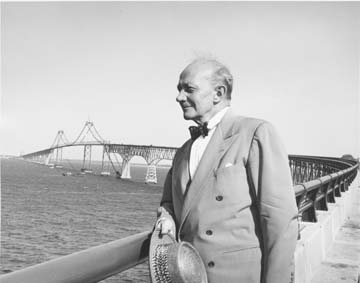
 William Preston Lane, Jr., for whom the bridge is named, stands on the original span shortly after construction was finished in 1952.
Proposals and ferries
Studies exploring the possibility of building a bridge across the Chesapeake Bay may have been conducted as early as the 1880s.[3] The first known proposal came about in 1907 and called for a crossing between Baltimore and Tolchester Beach; other proposals, occurring in the years 1918, 1919, 1926, and 1935, also called for a bridge in this location.[4] In 1927, local businesspeople were authorized to finance the construction of a Baltimore-Tolchester Beach crossing. Plans for the new bridge were made, but construction was canceled following the Stock Market Crash of 1929.[3]
Ferries were used as the main mode of transportation across the bay from the colonial period until the completion of the bridge. The first service ran from Annapolis to Broad Creek on Kent Island, roughly where the bridge is today.[5] In 1919 the Claiborne-Annapolis Ferry Company began running ferries between Annapolis and Claiborne, a community near St. Michaels. In July 1930, the company added a new ferry route, one running from Annapolis to Matapeake, a significantly shorter distance. The ferries were taken over by the State Roads Commission in 1941, and two years later the Commission moved the western terminus of the Annapolis–Matapeake ferry to Sandy Point, shortening the trip.
Construction
A 1938 proposal by the Maryland General Assembly, was the first to call for a bridge at the Sandy Point-Kent Island location.[4] Although the legislation authorizing the new bridge passed, the involvement of the United States in World War II delayed the bridge's construction. In 1947, with the war over, the assembly, under the leadership of Maryland Governor William Preston Lane, Jr., passed legislation directing the State Roads Commission to begin construction.[3] Ground was broken in January 1949, and on July 30, 1952 the bridge opened to traffic[6] as both the longest continuous over-water steel structure and third longest bridge in the world.[7] On November 9, 1967, the bridge was dedicated to Governor Lane, who had died earlier that year, and officially renamed the William Preston Lane, Jr. Memorial Bridge.
1973 expansion
Also in 1967, due to increasing traffic volumes, the Maryland General Assembly authorized three possible new crossings, all suggested during the 1964 Chesapeake Bay crossing study.[4] These included one near Baltimore, one in southern Maryland, and an additional span to be added to the existing bridge; ultimately, the third option was chosen. Construction of the new span began in 1969 to the north of the original span, and it was completed on June 28, 1973.[6]
Notable incidents
 Police block traffic leading up to the Bay Bridge during Hurricane Isabel due to high winds.
Several incidents related to the bridge have occurred in the past. In some cases, these have caused significant closures and traffic congestion on either side approaching the bridge. On September 18, 2003, during Hurricane Isabel, the bridge was temporarily closed due to high winds, marking the first time it was closed due to weather.[8][9] Other bridges in Maryland, even smaller bridges such as the nearby Kent Narrows Bridge, were also closed during the storm.
On May 10, 2007, three people were killed and five injured in an accident that closed the westbound span for seven hours.[10] The accident involved multiple collisions that started when a trailer separated from an SUV; investigators found no evidence of a safety pin having been installed on the SUV's trailer hitch, and found that the safety chains on the trailer were too long for use in towing.[11]
On August 10, 2008, a tractor trailer involved in a head-on collision fell from the bridge; the driver died in the crash.[12] The incident has highlighted concern that the bridge may not be structurally safe, but the Maryland Transportation Authority discounted any structural problems with the bridge.[13][14] Subsequent inspections of the wall in the weeks following the accident revealed that there was indeed deterioration in the form of corrosion of the steel reinforcements inside barriers; this prompted immediate repairs to the wall.[15]
On August 27, 2011, the bridge was closed to all traffic due to the impacts of Hurricane Irene. Maryland Governor Martin O'Malley ordered the bridge closed when sustained winds exceeded 55 miles per hour. This was the second time in the history of the bridge that it was closed due to weather, with both closures occurring since 2003.
Specifications and operations
 View of both spans from the Queen Anne's County side, in which the original 1952 span appears in front of the newer 1973 span.
With shore-to-shore lengths of 4.33 and 4.35 miles (6.97 and 7.00 km),[3] the two spans of the bridge form the longest fixed water crossing in Maryland and are also among the world's longest over-water structures. The bridge's western terminus is in Sandy Point State Park, located northeast of Annapolis in Anne Arundel County, and its eastern terminus is in Stevensville on Kent Island in Queen Anne's County.
Structural details
With the exception of the number of lanes on each (two on the original span and three on the newer span) and differences owing to the design standards for the periods in which they were built, the spans are structurally similar. Both were designed by J. E. Greiner Co., now a part of URS Corporation.[16] Each span features:
- Two main spans over the bay's two shipping channels:
- A 3,200-foot (975 m) suspension span over the western channel with a maximum clearance of 186 feet (56.7 m)— high enough to accommodate ocean-going vessels and tall ships
- A through-truss cantilever span over the eastern channel with a maximum clearance of 58 feet (17.7 m)
- Deck truss and steel girder spans flanking the main spans
- Concrete beam spans on the portions closest to the shores
- A curve near the western terminus, which is required so that the main spans cross the bay's shipping channels at 90 degrees per United States Army Corps of Engineers requirements[17]
 The westbound span at sunset. The leftmost lane is closed to westbound traffic.
Traffic control
Traffic patterns on the bridge's five lanes can be adjusted via its lane control system, which consists of overhead lane control signals on both spans and approaches. Typically, the two lanes on the south span are configured for vehicles traveling east on eastbound U.S. 50/northbound U.S. 301, while the three lanes on the north span are configured for vehicles traveling west on westbound U.S. 50/southbound U.S. 301; the spans are therefore referred to as the "eastbound span" and "westbound span", respectively. However, this pattern is adjusted during incidents or peak travel times: for instance, on the outset of weekends when there is a high volume of beach-bound traffic, one lane on the westbound span is configured for eastbound traffic.
Beginning in 2006, pink markers were placed along the eastbound span to mark out the suggested following distance, similar to systems used in Minnesota and Pennsylvania. The markers are a part of the MDTA's "Pace Your Space" campaign to prevent vehicle collisions and traffic congestion due to tailgating on the bridge.[18][19]
Tolls and fees
Operated by the Maryland Transportation Authority (MdTA), the bridge has a one-way (eastbound) toll of $4.00 for two-axle vehicles; vehicles with E-ZPasses that are enrolled in the Bay Bridge Commuter Plan pay $1.00.[20]
The MdTA contracts with private companies to provide transportation across the bridge for nervous drivers (gephyrophobiacs) and cyclists; fees are $25 and $30 for drivers and cyclists, respectively.[21]
Bay Bridge Walk and Run
While there are no pedestrian facilities on the bridge, the Bay Bridge Walk and Governor's Bay Bridge Run afford an opportunity to cross the bridge on foot, usually on the first Sunday in May.[22] The events take place on the eastbound span, which is closed to vehicles while two-way traffic shares the westbound span. Participants start on the east end of the bridge (on Kent Island) and proceed west to the finish near the toll plaza. WMATA and MTA transit buses transport participants between outlying parking areas and the start and finish points.
The run, a 10K race across the bridge, is held early in the morning before the walk. It is conducted by the Annapolis Striders, a local running organization, and controlled by the MdTA and Maryland Department of Natural Resources. Proceeds go to the Chesapeake Bay Trust in support of the bay.[23]
The walk was first held in 1975,[24] after a Boy Scout leader in Towson asked then-Governor Marvin Mandel if his troop could walk across the bridge while it was closed for maintenance.[22] The annual walk was canceled for the first time in 1980 due to poor weather conditions, and later saw frequent cancellations throughout the 2000s. During this period the walk was canceled in:
- 2002 and 2007 due to poor weather conditions.[25][26]
- 2003 and 2005 due to security concerns.[26]
- 2008, 2009, and 2010 due to construction activity in the area on the west side of the bridge where participants would otherwise be staged.[27] Fiscal concerns were also cited as a contributing factor to the 2010 cancellation.[28]
- 2011 due to fiscal concerns.[29]
Following their cancellation in 2005, the MDTA considered decreasing the annual frequency of the events, citing traffic, fiscal, manpower, and security concerns. Nevertheless, the events resumed in 2006.
Impact
 In the years since the bridge's completion, Ocean City (pictured) has experienced significant growth.
Since its construction, the bridge has made significant impacts on both sides of the bay, among them has been the growth of Eastern Shore communities. When the bridge opened in 1952, and again when the second span was added in 1973, the Eastern Shore was given easier access to Baltimore and Washington, causing areas in southern Queen Anne's County to develop as bedroom communities. This extension of the Baltimore-Washington suburbs has led Queen Anne's County to be listed as part of the Baltimore-Washington Metropolitan Area. The bridge has also given easier access to Ocean City from the Western Shore, which has caused Ocean City to grow from a small town to one that is said to become the second largest city in Maryland during the summer.[30]
In 1948, the impending completion of the bridge gave rise to an extension of U.S. Route 50 to Ocean City.[31] The route was extended along the corridor of Maryland Route 404 and a large portion of U.S. Route 213, cutting both of those routes back. During the 1950s, US 50 on the Western Shore was rerouted onto the long-proposed Annapolis-Washington Expressway (now known as the John Hanson Highway), which was built at the time in order to provide better access to the bridge.[32] As the Eastern Shore, particularly Ocean City, grew, further upgrades and realignments of US 50 took place. This work included the aforementioned 1973 completion of the second Bay Bridge span, the extension of the US 50 freeway eastward to the US 50/301 split in Queenstown, and the routing of US 50 onto the Salisbury Bypass in 2003. Additionally, the road has been upgraded and realigned over the years from its original 2-lane configuration to a 4-lane divided highway, with the last such section being in Vienna, which was bypassed in 1991.[33] As of 2008, there are plans for further upgrades to US 50, including extending its freeway portion in Queen Anne's County to Maryland Route 404 outside of Wye Mills and replacing the aging Harry W. Kelly Memorial Bridge into Ocean City.[34]
Future expansion
 The Bay Bridge from the airMain article: 2005 Chesapeake Bay crossing study
In December 2004, a study concluded that traffic across the bridge was expected to increase by 40% by 2025. The following year, a task force formed by Maryland Governor Robert Ehrlich met to again explore the possibility of establishing a new Chesapeake Bay crossing.[35] The task force concluded that a bridge would be the best option for an additional crossing, and four geographic locations for such a bridge were explored: Baltimore County to Kent County, Anne Arundel County to Queen Anne's County (the existing location), Anne Arundel or Calvert County to Talbot County, and Calvert County to Dorchester County.[36] In late 2006, the task force released a report on the study but did not make a final recommendation; members of the task force requested additional time to continue the study.[37]
Panorama
 Panoramic view of the bridge, looking south, in which the two main spans (suspension at center and through truss at left) are visible. The towers with the "X"-shaped latticework are on the eastbound (1952) suspension span, while those with the horizontal crossmembers are on the westbound (1973) suspension span. Notice the difference in the locations of the anchoring points of the main cables: at water level for the eastbound span and at deck level atop large concrete piers for the westbound span.
See also
- Harry W. Kelly Memorial Bridge
- Kent Narrows Bridge
- List of bridges by length
- Severn River Bridge
- U.S. Route 50 in Maryland
- U.S. Route 301 in Maryland
Notes
- ^ Maryland State Highway Administration (2008). "Highway Location Reference: Anne Arundel County" (PDF). http://www.sha.state.md.us/KeepingCurrent/performTrafficStudies/dataAndStats/hwyLocationRef/2008_hlr_all/co02.pdf. Retrieved 2010-02-24.
- ^ Maryland State Highway Administration (2008). "Highway Location Reference: Queen Anne's County" (PDF). http://www.sha.state.md.us/KeepingCurrent/performTrafficStudies/dataAndStats/hwyLocationRef/2008_hlr_all/co17.pdf. Retrieved 2010-02-24.
- ^ a b c d "The William Preston Lane Jr. Memorial Bridge" (PDF). Maryland Transportation Authority. http://www.mdta.state.md.us/mdta/Documents/baybridge.pdf. Retrieved 2007-10-26.
- ^ a b c Kozel, Scott. "Chesapeake Bay Bridge History". Roads to the Future. http://www.roadstothefuture.com/Chesa_Bay_Bridge_History.html. Retrieved 2007-10-26.
- ^ Gayman, Jennifer. "Kent Island". Maryland Online Encyclopedia. http://www.mdoe.org/kentisland.html. Retrieved 2007-11-18.
- ^ a b "William Preston Lane Jr. Memorial Bay Bridge - History". baybridge.com. http://www.baybridge.com/cms/index.php?option=com_content&task=view&id=16&Itemid=. Retrieved 2008-02-05.
- ^ "William Preston Lane Jr. Memorial Bay Bridge - Engineering Feats". baybridge.com. http://www.baybridge.com/cms/index.php?option=com_content&task=view&id=28&Itemid=. Retrieved 2008-02-05.
- ^ "Hurricane Isabel photo log". Indepth:Forces of Nature (CBC News). September 18, 2003. http://www.cbc.ca/news/background/forcesofnature/isabel_photolog.html. Retrieved 2007-11-16.
- ^ Martin, Patrick (September 25, 2003). "US: Millions still without power a week after Hurricane Isabel". World Socialist Website. http://www.wsws.org/articles/2003/sep2003/isab-s25.shtml. Retrieved 2007-11-16.
- ^ Edwards, Dennis (May 14, 2007). "Funerals Set For All 3 Victims In Bay Bridge Crash". WJZ-TV. Archived from the original on 2007-09-27. http://web.archive.org/web/20070927195449/http://wjz.com/topstories/local_story_130165233.html. Retrieved 2007-10-09.
- ^ Valcourt, Derek (October 24, 2007). "Bay Bridge Crash Investigation Concludes". WJZ-TV. Archived from the original on 2007-10-26. http://web.archive.org/web/20071026080210/http://wjz.com/topstories/local_story_297121451.html. Retrieved 2007-10-25.
- ^ St. George, Donna; Birnbaum, Michael (August 11, 2008). Traffic Continues to Stall on Bay Bridge. The Washington Post. http://www.washingtonpost.com/wp-dyn/content/article/2008/08/11/AR2008081100422.html?nav=hcmodule. Retrieved 2008-08-11
- ^ May, Adam (2008-08-11). "Eastbound Right Lane Reopens On Bay Bridge". WJZ. http://wjz.com/local/bay.bridge.crash.2.792465.html. Retrieved 2008-08-12.
- ^ Witte, Brian (2008-08-11). "Engineer says bridge wall shows no sign of deterioration". Examiner.com. http://www.examiner.com/a-1531862~Engineer_says_bridge_wall_shows_no_sign_of_deterioration.html?cid=temp-popular. Retrieved 2008-08-12.[dead link]
- ^ Dominguez, Alex (August 27, 2008). "Bay Bridge walls had corrosion, tests show". The Free Lance-Star. http://fredericksburg.com//News/FLS/2008/082008/08272008/405943. Retrieved 2008-08-30.
- ^ Legler, Dixie; Highsmith, Carol (2002). Historic Bridges of Maryland. Crownsville, Md.: Maryland Historic Trust. pp. 46. ISBN 1-878399-80-2. http://www.sha.state.md.us/KeepingCurrent/maintainRoadsBridges/bridges/oppe/bridgebook/bridge_book.asp
- ^ "William Preston Lane Jr. Memorial Bridge — Fun Facts [Family Fun"]. Maryland Transportation Authority. http://www.baybridge.com/cms/index.php?option=com_content&task=view&id=29&Itemid=. Retrieved 2007-10-09.
- ^ "SAFETY TIPS for traveling the Bay Bridge". Maryland Transportation Authority. http://www.baybridgeproject.com/safetytips.html. Retrieved 2007-10-09.
- ^ Gramlich, John (July 07, 2006). "State DOTs hope drivers see dots". Stateline.Org. http://www.stateline.org/live/details/story?contentId=125133.
- ^ "Toll Rates for the William Preston Lane Jr. Memorial (Bay) Bridge (US 50/301)". http://www.mdta.maryland.gov/TollRates/baybridge_rates.html. Retrieved 11/5/2011.
- ^ "Safe Travel Tips". Maryland Transportation Authority. http://www.baybridge.com/cms/index.php?option=com_content&task=view&id=24&Itemid=. Retrieved 2009-11-30.
- ^ a b "Governor O'Malley Announces Plans to Host 2007 Bay Bridge Walk" (Press release). Maryland Department of Transportation. 2007-02-23. http://www.e-mdot.com/News/2007/February%202007/Bay%20Bridge%20walk.htm. Retrieved 2008-09-01. "The first Sunday in May means Bay Bridge Walk"
- ^ "The 22nd Governor’s Bay Bridge Run". Annapolis Striders. http://annapolisstriders.org/gbbrInfo2007.htm. Retrieved 2007-11-16.
- ^ Kozel, Scott. "Chesapeake Bay Bridge Walk". Roads to the Future. http://www.roadstothefuture.com/Chesa_Bay_Bridge_Walk.html. Retrieved 2007-11-16.
- ^ Schuyler, Jim (May 6, 2007). "High Winds Cancel Bay Bridge Walk". WJZ-TV. Archived from the original on 2007-12-27. http://web.archive.org/web/20071227223020/http://wjz.com/topstories/local_story_126105130.html. Retrieved 2007-11-16.
- ^ a b Yanovits, Dave (May 7, 2007). "Race Canceled for 4th Time in Six Years". The Washington Post. http://www.washingtonpost.com/wp-dyn/content/article/2007/05/06/AR2007050601014.html. Retrieved 2007-11-16.
- ^ "Bay Bridge Walk Canceled for 2008, 2009". WTOP News. December 6, 2007. http://www.wtop.com/?nid=715&sid=1305650. Retrieved 2008-02-06.
- ^ Basch, Michelle. Bay Bridge Walk cancelled for 4th year in a row. WTOP. http://www.wtopnews.com/?nid=598&sid=1903428. Retrieved 2010-03-14
- ^ http://www.baybridge.com/cms/index.php?option=com_content&task=view&id=17&Itemid=
- ^ Johnson, Darragh; Hernandez, Nelson (July 30, 2002). "Spanning Half a Century". The Washington Post. http://www.washingtonpost.com/ac2/wp-dyn?pagename=article&node=&contentId=A18858-2002Jul29¬Found=true. Retrieved 2007-10-09.
- ^ "End of U.S. highway 50". August 10, 2007. Archived from the original on 2009-07-29. http://web.archive.org/web/20090729182235/http://geocities.com/usend5059/End050/end050.htm. Retrieved 2007-11-16.
- ^ Anderson, Steve. "John Hanson Highway". dcroads.net. http://www.dcroads.net/roads/I-595_MD/. Retrieved 2008-02-06.
- ^ Dukes, Corey (August 1, 2007). "Abandoned US 50 / US 213 — Vienna, MD". Delmarva Highways. http://www.delmarvahighways.com/old50-vienna.htm. Retrieved 2007-10-09.
- ^ Dukes, Corey (January 19, 2004). "Ocean Gateway — Ocean City, MD to MD 90 Interchange". Delmarva Highways. http://www.delmarvahighways.com/us50.htm. Retrieved 2007-10-09.
- ^ Berman, Dori (June 27, 2005). "Task force says second Chesapeake Bay bridge is best option". The Baltimore Daily Record. http://findarticles.com/p/articles/mi_qn4183/is_20050627/ai_n14693744. Retrieved 2008-02-05.
- ^ "Meeting #2: Bridge, Traffic, and Highway Issues" (pdf). Maryland Transportation Authority. http://www.mdta.state.md.us/mdta/BayCrossing/BriefingBook/Taskforce_Briefing_Book_2-001.pdf. Retrieved 2008-02-05.
- ^ Wyatt, Kristen (August 29, 2006). "Bay Bridge Report Released without Recommendation". WTOP news. http://www.wtopnews.com/?nid=25&sid=896776. Retrieved 2008-02-05.
External links
- Chesapeake Bay Bridge official website
- Bay Bridge Page at MdTA website
- William Preston Lane Jr. Memorial Bridge – Fact Sheet (pdf)
- Roads to the Future website
- Page at dcroads.net
- Chesapeake Bay Bridge at Structurae
- Live Video Rt 50 Kent Island
- Live Video Rt 50 Sandy Point
Maryland Transportation Authority facilities Bridges Tunnels Highways Railroads Bridges of the Chesapeake Bay Upstream
P.W. & B. Railroad Bridge
(Susquehanna River)
Francis Scott Key Bridge
Chesapeake City Bridge
(Patapsco River)

(Chesapeake and Delaware Canal)

Chesapeake Bay Bridge


Downstream
Chesapeake Bay Bridge-Tunnel
 Categories:
- Buildings and structures in Anne Arundel County, Maryland
- Buildings and structures in Queen Anne's County, Maryland
- Chesapeake Bay
- Bridges completed in 1952
- Bridges completed in 1973
- Toll bridges in Maryland
- Suspension bridges in the United States
- Intracoastal Waterway
- U.S. Route 50
- U.S. Route 301
- Landmarks in Maryland
- Road bridges in Maryland
- Two main spans over the bay's two shipping channels:


Wikimedia Foundation. 2010.