- Dunfanaghy
-
Dunfanaghy
Dún Fionnachaidh— Village — A view of Dunfanaghy main street. Location in Ireland
 Dunfanaghy
Coordinates: 55°10′59″N 7°58′16″W / 55.183°N 7.971°WCoordinates: 55°10′59″N 7°58′16″W / 55.183°N 7.971°W Country Ireland Province Ulster County County Donegal Elevation 15 m (49 ft) Population (2006)[1] - Total 316 Time zone WET (UTC+0) - Summer (DST) IST (WEST) (UTC-1) Irish Grid Reference C015372 Dunfanaghy (Dún Fionnachaidh, fort of the fair-haired warrior, in Irish) is a small village, formerly a fishing port and commercial centre, in County Donegal, Ireland. Dunfanaghy is located on Donegal's North West coast, specifically the west side of Sheephaven Bay. It is on the N56 road.
Contents
Description
The centre of Dunfanaghy is a small square with a market house built in 1847 and a quay built in 1831 and formerly used to export corn. There are four churches: Clondehorky Old Church (now ruined), Dunfanaghy Presbyterian Church, Holy Cross (Roman Catholic) and Holy Trinity (Church of Ireland). The village is also home to a golf club, several art galleries and craft shops, and a museum, situated in part of a former workhouse, which describes the effects of the Irish Potato Famine on Dunfanaghy. Dunfanaghy is also home to St. Michael's (Naomh Mícheál in Irish) Gaelic football club.
 View of Dunfanaghy from Horn Head.
Local Area
Just north of the village is a three-mile-long sandy beach known as Killahoey Strand. On May 2, 1943, a Flying Fortress of the USAAF on a ferry flight to Northern Ireland landed on the beach after running out of fuel. The crew were entertained in the local hotel and the aircraft refuelled and took off again (to be destroyed 6 weeks later over Germany).
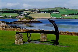 A disused anchor on dislay in the centre of the village.
South of Dunfanaghy are New Lake and Tramore Strand, a two-mile-long beach. New Lake was formerly a salt water marsh, but during the First World War, over-cutting of the grass on the surrounding sand dunes led to their destabilisation and the movement of the sand to block up the river. As a result, the marsh filled with fresh water and became a lake. The sand also silted up Dunfanaghy harbour. The New Lake became a haven for seabirds and is now a Special Protection Area. Also nearby is Sessiagh Lough, a small lough with a crannog in the middle.
Across the bay from Dunfanaghy is Horn Head, which shelters Dunfanaghy from the Atlantic Ocean and is an Irish Natural Heritage Area. Dunfanaghy is close to Portnablagh and Marble Hill, both of which also have popular beaches. Other sights in the vicinity include: Ards Forest Park, Ards (Capuchin) Friary, Glenveagh National Park, Doe Castle and the Derryveagh Mountains, the most prominent being Muckish Mountain and Mount Errigal.
Workhouse
 Dunfanaghy Workhouse Heritage Centre
As in many parts of Ireland in the mid nineteenth century, a Workhouse was constructed nearby for the detention and maintenance of destitute local people. The first occupants were admitted in June 1845,[2] at the beginning of the Great Famine. Parts of the original building have recently been restored and now function as an interpretive centre of the Famine and its impact on the local inhabitants.
Near the workhouse, on the Falcarragh road, is the former Union fever hospital. Closed in 1922, it was reopened as a national school in the 1930s and fulfilled this role until the 1960s. Since 1968 it has been used as an artists studio and gallery.[3]
Transport
Dunfanaghy Road was previously a stop on the Londonderry and Lough Swilly Railway although the station was in fact six miles from Dunfanaghy itself. Dunfanaghy Road railway station opened on 9 March 1903, closed for passenger traffic on 3 June 1940 and finally closed altogether on 6 January 1947.[4] Lough Swilly Buses still serve the area with four buses per day going from Dunfanaghy to Letterkenny and vice versa. Lough Swilly Busses also provide school buses to primary schools and the main secondary schools St Eunan's College and Loreto Convent in Letterkenny during the school terms.
See also
References
- ^ "Census 2006 – Volume 1 – Population Classified by Area" (PDF). Central Statistics Office Census 2006 Reports. Central Statistics Office Ireland. April 2007. http://www.cso.ie/census/documents/census2006_volume_1_pop_classified_by_area.pdf. Retrieved 2011-06-25.
- ^ Dudley Edwards, Robert (1976). Robert Dudley Edwards &Thomas Desmond Williams. ed (in 26/04/2010). The great famine: studies in Irish history, 1845-52. Russell & Russell. pp. 311. ISBN 9780846217930. http://books.google.ie/books?ei=tEvYS6rAEoj3-Ab4hdGQBg&ct=result&id=BJDtAAAAMAAJ&dq=Dunfanaghy+workhouse+edwards&q=%22Dunfanaghy+workhouse+%22#search_anchor.
- ^ "The Gallery". discoverireland.ie. 2009. http://www.discoverireland.ie/Search-Results/Details.aspx?touristItemID=1308. Retrieved 30 April 2010.
- ^ "Dunfanaghy Road station". Railscot - Irish Railways. http://www.railscot.co.uk/Ireland/Irish_railways.pdf. Retrieved 2007-10-12.
- Alistair Rowan (1979). The Buildings of Ireland: North West Ulster. Yale University Press. ISBN 0-300-09667-4.
External links
Categories:- Towns and villages in County Donegal
- Beaches of the Republic of Ireland
- Important Bird Areas of the Republic of Ireland
- Articles on towns and villages in Ireland possibly missing Irish place names


Wikimedia Foundation. 2010.