- Cruzeiro, São Paulo
-
Coordinates: 22°34′38″S 44°57′30″W / 22.57722°S 44.95833°W
Map 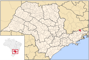
Coat of Arms Flag 
Statistics State: São Paulo Meso-region: Vale do Paraíba Paulista Microrregions: Guaratinguetá Founded: 2 October 1901 Location: 22.573/22° 34' 38" S, 46.958/46° 57' 30" W Area: 167.38 km² Population:
Change from 200074,986(2004)
Ranked
up from 2.03%Population density: 246.18/km² Elevation: 508 m Postal code: 12700-xxx Area/distance code: (00)55-12-31xx-xxxx Climate: Subtropical Name of inhabitants or denomym: Cruzeirense Website: www.cruzeiro.sp.gov.br Politics Mayor: Celso de Almeida Lage
(PMDB)Population Statistics (as of 2001) Urban: 71,129 Rural: 2,123 Other Literacy rate: 95.23% Distance from the state capital: 210 km Cruzeiro (Portuguese meaning the Southern Cross, the Brazilian national symbol that is used in its coat of arms and its flag) is a city in the state of São Paulo in Brazil. It is located about 220 km (137 mi) from the state capital. The population reached 70,000 in 2000 and the 2004 population read 74,986 and the area is 331 km2 (128 sq mi).
Contents
Distances
- São Paulo - 210 km (130 mi)
- Rio de Janeiro - 213 km (132 mi)
- Caxambu - 98 km (61 mi)
- Campos do Jordão - 101 km (63 mi)
- São José dos Campos - 120 km (75 mi)
Population history
Year Population Change Density 2000 73,492 - 241.27/km² 2004 74,986 +1,494 or 2.03% 246.18/km² Coat of arms
Its coat of arms features a shield with blue on the top and white at the bottom with its part of a flag in the top left and the Southern Cross which has its golden stars on the right.
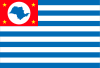
Flag
Its flag colors are red on the top left with four golden stars with a white circle and its state (São Paulo) where the city is located in the middle and with 13 stripes, seven of them are blue and six of them are white. It has a red tag reading in Portuguese Cultura Civismo meaning Civic Culture on the left, Paz meaning Peace in the middle and Liberdade e Trabalho meaning Freedom and Work on the bottom and a golden crown on the top.
Geography
Its geography is considered one of the largest investments in Brazil, it is located in the radius of 200 km (124 mi) and a population of around 40 million people. The municipality is situated at the foot of the Serra da Mantiqueira which has the elevation of 517 m (1,696 ft), the mountains of the north reaches its elevations up to 2,800 m (9,186 ft). By the area around the president Dutra Highway, the area features cliffs which divides the state of Minas Gerais. At the division is the Serra da Mantiqueira, the lowest point near the pass with the Serra da Mantiqueira. The rio Paraíba do Sul flows into the city.
History
Cruzeiro was founded in the railway lines of three states (São Paulo, Minas Gerais and Rio de Janeiro), the railway was important as well as coffee production in the 19th century.
The first proprietary of the Cruzeirense lands were Major Novaes, a resident of Fazenda Dona Tita, now a city museum.
The city disenvolved as places of the railway.
The city also features a tunnel called the Mantiqueira which were used for troops during the important battle between the federalists and the constitutionalists.
Today, the city contains an economic focus on the area in the commercial and metallurgical industry. The old FNV (Fábrica Nacional de Vagões) which is now an international company that makes rail components, making up a large part of the fragile economy.
Transportation
The city are linked with three highways, the BR-116 and the state highways of SP-52 and SP-58
Twin towns
Cruzeiro is twinned with
External links
- http://www.cruzeiro.sp.gov.br (Portuguese)
- Cruzeiro on citybrazil.com.br (Portuguese)
- Municipal anthem of Cruzeiro (Portuguese)
North: Passa-Quatro, Minas Gerais West: Piquete Cruzeiro East: Lavrinhas Southwest: Piquete South: Cachoeira Paulista Southeast: Silveiras Categories:- Populated places in São Paulo (state)
- Populated places established in 1901


Wikimedia Foundation. 2010.