- Cortland Township, DeKalb County, Illinois
-
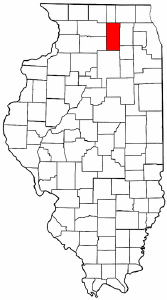
Cortland Township — Township — Location in DeKalb County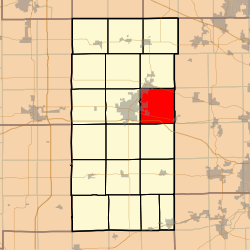 DeKalb County's location in Illinois
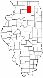
Coordinates: 41°56′00″N 88°39′00″W / 41.9333333°N 88.65°WCoordinates: 41°56′00″N 88°39′00″W / 41.9333333°N 88.65°W Country  United States
State  Illinois
County DeKalb Established February 1, 1865 Area – Total 35.3 sq mi (91.43 km2) – Land 35.25 sq mi (91.3 km2) – Water 0.05 sq mi (0.12 km2) 0.13% Elevation 850 ft (259 m) Population (2000) – Total 6,986 – Density 198.2/sq mi (76.5/km2) Time zone CST (UTC-6) – Summer (DST) CDT (UTC-5) ZIP codes 60112, 60115, 60151, 60178 GNIS feature ID 0422242 Cortland Township is one of nineteen townships in DeKalb County, Illinois, USA. As of the 2000 census, its population was 6,986[1]. Cortland Township was originally named Richland Township, but was renamed to Pampas Township on November 20, 1850; it was renamed to Cortland Township on February 1, 1865.
Contents
Geography
According to the United States Census Bureau, Cortland Township covers an area of 35.3 square miles (91 km2); of this, 35.25 square miles (91.3 km2) (99.86 percent) is land and 0.05 square miles (0.13 km2) (0.13 percent) is water.
Cities, towns, villages
- Cortland
- Dekalb (east edge)
- Maple Park (partial)
- Sycamore (partial)
Cemeteries
The township contains these three cemeteries: Mound Rest, Mount Pleasant and Ohio Grove.
Airports and landing strips
- DeKalb Taylor Municipal Airport
- Ruder Airport
School districts
- Dekalb Community Unit School District 428
- Kaneland Community Unit School District 302
- Sycamore Community Unit School District 427
Political districts
- Illinois's 14th congressional district
- State House District 70
- State Senate District 35
References
- "Cortland Township, DeKalb County, Illinois". Geographic Names Information System, U.S. Geological Survey. http://geonames.usgs.gov/pls/gnispublic/f?p=gnispq:3:::NO::P3_FID:0422242. Retrieved 2010-07-04.
- United States Census Bureau 2009 TIGER/Line Shapefiles
- United States National Atlas
External links

Mayfield Township Sycamore Township Burlington Township, Kane County DeKalb Township 
Virgil Township, Kane County  Cortland Township

Afton Township Pierce Township Kaneville Township, Kane County Municipalities and communities of DeKalb County, Illinois Cities 
Town Villages Townships Unincorporated
communitiesAfton Center | Charter Grove | Clare | Colvin Park | East Paw Paw‡ | Elva | Fairdale | Five Points | Franks | McGirr | New Lebanon | Rollo | Shabbona Grove | Wilkinson
Ghost towns Footnotes ‡This populated place also has portions in an adjacent county or counties
Categories:- Townships in DeKalb County, Illinois
- 1865 establishments

Wikimedia Foundation. 2010.