- Bar Yehuda Airfield
-
Bar Yehuda Airfield 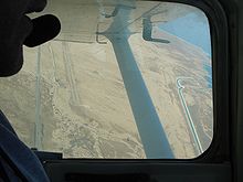
IATA: MTZ – ICAO: LLMZ Summary Airport type Public Operator Sun Air Aviation, Tamar Regional Council Location Masada Elevation AMSL -1,240 ft / -378 m Coordinates 31°19′41.41″N 35°23′18.99″E / 31.3281694°N 35.3886083°ECoordinates: 31°19′41.41″N 35°23′18.99″E / 31.3281694°N 35.3886083°E Runways Direction Length Surface ft m 01/19 3,937 1,200 Asphalt Bar Yehuda Airfield (Hebrew מנחת בר־יהודה, minḥat bar-yehuda; sometimes known as Masada Airfield) (IATA: MTZ, ICAO: LLMZ), named after Israel Bar-Yehuda, is a small desert airfield located in the southern Judean desert, between Arad and Ein Gedi, west of the Dead Sea. Opened in 1963, it is just 4.2 km (2.6 mi) from the Metsadah fortress access and about one hour and a half drive from Jerusalem, Israel. The airfield is a public concession, mainly used as an alternate airport, and for charter and sightseeing flights.
Located at 1,240 ft (378 m) below mean sea level, Bar Yehuda Airfield is the lowest airport in the world.
External links
 Israeli airportsItalics indicate airports located in the Israeli-occupied territories.
International Domestic Bar Yehuda · Be'er Sheva · Eilat · Ein Yahav · Fik · Haifa · Herzliya · Megiddo · Mitzpe Ramon · Rosh Pina Ben Ya'akov · Sde Dov · Yotvata
Military Former 
This article about transport in Israel is a stub. You can help Wikipedia by expanding it.
