- Monk (Montreal Metro)
-
 Montreal Metro Station
Borough Le Sud-Ouest City Montreal Opened 3 September 1978 Line  Green Line
Architect Blais & Bélanger Artist Germain Bergeron Platform Depth 18.3 metres Rank 18th deepest Traffic 1,156,323 entrances in 2006 Rank 59th busiest Interstation
Distance844.29 metres to Angrignon
1062.85 metres to JolicoeurAddress of
Entrances6750 Monk Boulevard
6805 Monk BoulevardNearby Main
IntersectionsMonk Boulevard / Allard Street [1]
Monk is a station on the Green Line of the Montreal Metro rapid transit system operated by the Société de transport de Montréal (STM). The station is located in the Ville-Émard district of the borough of Le Sud-Ouest in Montreal, Quebec, Canada. [2]Contents
Art and Architecture
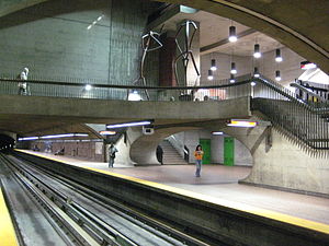
The station structure was designed by Blais & Bélanger and features many works of art, including the large sculpture Pic et Pelle by artist Germain Bergeron. Monk also features many balconies that overlook the main station below, however they have been closed for the safety of the visually impaired.
Germain Bergeron considered many different ideas for the public art for this station. His first concept was to create a series of flying saucers that were suspended from the roof of the station, and were to move with the wind generated by passing trains. However, this was deemed too dangerous by authorities, and the idea was cancelled.
The current two giant statues of workers constructing the Metro were to have been accompanied by a third, representing a foreman, but this idea was judged superfluous and scrapped.
Origin of the name
The station is named for boulevard Monk, itself named to honour Sir James Monk (1745-1826). Monk was a prosecutor who served on Quebec's vice admiralty court from 1778 to 1788 and subsequently became Montreal's chief justice from 1793 to 1820.
Connecting bus routes
Main article: Société de transport de MontréalMain article: List of Montreal Bus RoutesRoute Service Times Map Schedule Société de transport de Montréal  36 Monk
All-day Map Schedule 78 LaurendeauAll-day Map Schedule  350 Verdun/LaSalle
Overnight Map Schedule Nearby points of interest
- Centre hospitalier Ville Émard
- Douglas Hospital [3] [4] [5]
- École Dollard-des-Ormeaux
- École St-Jean-de-Matha
- École Honoré-Mercier
References
- ^ Monk Station Neighbourhood Map
- ^ Monk Station
- ^ Douglas Hospital Contact
- ^ Douglas Hospital Map
- ^ Getting to the Douglas, Station Monk (15 minutes walk)
External links
- Monk Station- Official site
- Montreal by Metro www.metrodemontreal.com - photos and information
- 2008 STM System Map
Line 1 Green Angrignon • Monk • Jolicoeur • Verdun • De L'Église • LaSalle • Charlevoix • Lionel-Groulx • Atwater • Guy-Concordia • Peel • McGill • Place-des-Arts • Saint-Laurent • Berri-UQAM • Beaudry • Papineau • Frontenac • Préfontaine • Joliette • Pie-IX • Viau • Assomption • Cadillac • Langelier • Radisson • Honoré-BeaugrandLine 2 Orange Côte-Vertu • Du Collège • De La Savane • Namur • Plamondon • Côte-Sainte-Catherine • Snowdon • Villa-Maria • Vendôme • Place-Saint-Henri • Lionel-Groulx • Georges-Vanier • Lucien-L'Allier • Bonaventure • Square-Victoria • Place-d'Armes • Champ-de-Mars • Berri-UQAM • Sherbrooke • Mont-Royal • Laurier • Rosemont • Beaubien • Jean-Talon • Jarry • Crémazie • Sauvé • Henri-Bourassa • Cartier • De La Concorde • MontmorencyLine 4 Yellow Line 5 Blue Snowdon • Côte-des-Neiges • Université-de-Montréal • Édouard-Montpetit • Outremont • Acadie • Parc • De Castelnau • Jean-Talon • Fabre • D'Iberville • Saint-MichelCoordinates: 45°27′4.18″N 73°35′35.23″W / 45.4511611°N 73.5931194°W
Categories:- Montreal Metro Green Line

Wikimedia Foundation. 2010.