- Cayey, Puerto Rico
Infobox Settlement
settlement_type =
subdivision_type = Country
subdivision_name =United States
subdivision_type1 = Territory
subdivision_name1 =Puerto Rico
subdivision_type2 =
subdivision_name2 =
timezone=AST
utc_offset=-4
timezone_DST=
utc_offset_DST=
unit_pref=Imperial
map_caption =Location of Cayey, Puerto Rico within Puerto Rico.
latNS=N
longEW=W| official_name = Cayey, Puerto Rico | nickname = Ciudad de las Brumas", "Ciudad del Torito", "Ciudad del Coquí Dorado
image_caption = Cayey landscape from PR-52 expressway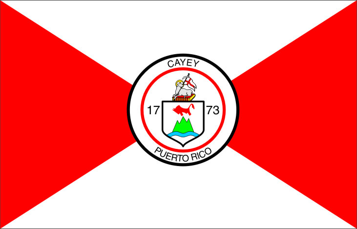
image_
blank_info = Cayeyanos|blank_name=Gentilic|
blank_info = Cayeyanos|blank_name=Gentilic|
| map_caption = Location within the island ofPuerto Rico
Country |Puerto Rico
established_date = August|established_title=Founded| 17, 1773 | leader_title =Mayor | leader_title=Mayor
leader_name = Hon. Rolando Ortíz Velázquez
leader_party = Partido Popular Democrático
political party display = PPD
leader_title1=Senatorial dist.
leader_name1= 6 - Guayama
leader_title2=Representative dist.
leader_name2 = 29 | area_magnitude = | area_total_km2 = 130.01
area_land_km2 = 130| area_water_km2 = .01 | population_as_of = 2000 | population_note =
population_total = 47370|population_footnotes= | population_density_km2 = 342.6| timezone = AST | utc_offset = -4 | timezone_DST = | utc_offset_DST = -4| latd= |latm= |lats=
longd=|longm= |longs=
population_blank2_title = Racial groups
(2000 Census) [ [http://www.topuertorico.org/pdf/2kh72.pdf Demographics/Ethnic U.S 2000 census] ]
population_blank2 = 88.2% White 3.9% Black 0.2% American Indian/AN 0.1% Asian 0.1%Native Hawaiian /PI 5.5% Some other race 2.1% Two or more races|latitude =
longitude =
website =
footnotes = Anthem – "Alma Boricua" |Cayey (ka-YAI) is a mountain town in central
Puerto Rico located on the Central Mountain range, north of Salinas and Guayama; south of Cidra and Caguas; east of Aibonito and Salinas; and west of San Lorenzo Cayey is spread over 21 wards and Cayey Pueblo (The downtown area and the administrative center of the city).Cayey is notable for its surrounding mountains. The city has been actively growing since the 1990s, evidenced by its designation as a Metropolitan Area by the U.S. Census Bureau. It has experienced significant growth in commerce, and many major retailers, such as
Wal-Mart have opened stores in this city. A new coliseum and hospital facilities have also been built.Coca-Cola andProcter & Gamble are two major corporations that have manufacturing facilities in the town. Cayey is host to one of the main campuses of the University of Puerto Rico. TheUniversity of Puerto Rico at Cayey is the only liberal arts college in Puerto Rico.History
Cayey was founded on August 17, 1773 by Juan Mata Vázquez, who became its first mayor. It is said that Cayey derives its name from the Taino Indian word for "a place of waters". Its original name was "Cayey de Muesas".
During
1880 , a fire that later acquired legendary status happened in Cayey'sMirador Echevarria area. The fire broke out on the property of a timber company nearCharca Del Pato . Many people and dogs died, and legend has it that the dogs' barking can still be heard, and sometimes, at night, the screams of the men who burned to death can still be heard too.During the first half of the 20th century, Cayey was basically an agricultural area of small farmers and local haciendas dedicated to the farming of crops for the local market. During the 1920s and 1930's farmers increasingly lost their land to absentee landowners, mostly American companies, that turned to the cultivation of sugar cane and, to a lesser extent, tobacco for export. In the 1950s and 1960's some manufacturing concerns established plants in Cayey taking advantage of tax incentives offered by "Operation Bootstrap", Puerto Rico's industrialization program. Among the most notable were the "Consolidated Cigars", making cigars, and what was locally known as "Gordon Shire", a textile plant. These plants created hundreds of manufacturing jobs, mostly for women, and created a housing boom. In the 1960s new housing developments, like "Reparto Montellano", provided new housing for Cayey's increasing population outside of the town proper. By that time, however, you could still see vast sugarcane fields in the "Montellano" area of Cayey and the "Central" where the sugarcane was processed. You could likewise see barns dotting the mountainsides where tobacco was hung to dry. In 1967 the University of Puerto Rico opened a campus in Cayey at the old "Henry Barracks", an abandoned WWI U.S Army base. In the early 1970s PR-52 was completed connecting the North and South coastal areas of Puerto Rico and passing through the mountains of Cayey. PR-52, a multi-lane toll highway, rises from the town of Caguas before taking the path of less resistance in the Valley of Cayey, where it ascends further through the mountains before descending to the coastal town of Salinas.
Flag
The flag derives its design and colors from the Coat of Arms, which is in the center of the flag encircled by a solid black ring. The centered Coat of Arms and has four triangles pointing to it, two white and two red.
Coat of Arms
The Coat of Arms has a three tip mountain, a red bull, and a waving blue stripe representing the abundant water in the zone and also in reverence to the primitive Matron of the town of Cayey. The shield is topped with the silver lamb symbol of San Juan of Puerto Rico, and a red book.
Demographics
Racial distributionLook at other dictionaries:
Cayey (Puerto Rico) — Cayey (Porto Rico) Cayey (Porto Rico) Administration Pays États Unis … Wikipédia en Français
Lapa (Cayey, Puerto Rico) — Lapa Barrio de los Estados Unidos … Wikipedia Español
Monte Llano (Cayey, Puerto Rico) — Monte Llano Barrio de los Estados Unidos … Wikipedia Español
Toíta (Cayey, Puerto Rico) — Toíta Barrio de los Estados Unidos … Wikipedia Español
Vegas (Cayey, Puerto Rico) — Vegas Barrio de los Estados Unidos … Wikipedia Español
Puerto Rico Highway 14 — is a main highway connecting Cayey, Puerto Rico to Ponce, Puerto Rico. Though in a map it can be seen as a shortcut to Ponce (instead of taking PR 52 south to Salinas), it is a rural road and takes longer to arrive to Ponce. It is the main route… … Wikipedia
Puerto Rico Highway 206 — is a connector in Cayey, Puerto Rico that bypasses the downtown area of Cayey, making easier for drivers who do not want to access the congested area of the business center to directly go from Puerto Rico Highway 1 to Puerto Rico Highway 14 to… … Wikipedia
Puerto Rico Highway 15 — is a main highway connecting Cayey, Puerto Rico and Guayama, Puerto Rico. It takes longer than going south to Salinas through PR 52 and taking PR 53 to Guayama, due to being a rural road.ee also*Cayey, Puerto Rico *Guayama, Puerto Rico … Wikipedia
Puerto Rico Highway 184 — is a main, rural highway that connects Cayey, Puerto Rico, with plans to be extended to Cidra, to Patillas, Puerto Rico. It is the main and only access to the various famous roasted pork restaurants ( lechoneras ) in the area of Guavate and the… … Wikipedia
Puerto Rico — Puerto Rican. /pwer teuh ree koh, pwer toh, pawr teuh, pohr /; Sp. /pwerdd taw rddee kaw/ an island in the central West Indies: a commonwealth associated with the U.S. 3,196,520; 3435 sq. mi. (8895 sq. km). Cap.: San Juan. Formerly (until 1932),… … Universalium
- Contact us: Technical Support, Advertising
Cayey, Puerto Rico
18+
© Academic, 2000-2024
Dictionaries export, created on PHP, Joomla, Drupal, WordPress, MODx.