- Crowmarsh
-
Coordinates: 51°35′N 1°06′W / 51.58°N 1.10°W
Crowmarsh 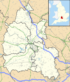
 Crowmarsh
Crowmarsh shown within OxfordshirePopulation 1,428 (2001 Census)[1] Parish Crowmarsh District South Oxfordshire Shire county Oxfordshire Region South East Country England Sovereign state United Kingdom Post town Wallingford Postcode district OX 10 Dialling code 01491 Police Thames Valley Fire Oxfordshire Ambulance South Central EU Parliament South East England UK Parliament Henley List of places: UK • England • Oxfordshire Crowmarsh is a civil parish in South Oxfordshire, England.
Contents
Formation and constituent settlements
The civil parish was formed on 1 April 1932 by the amalgamation of four existing parishes.[2]
The four parishes retain their individual identities as the villages of Crowmarsh Gifford, North Stoke, Mongewell and Newnham Murren.[3]
Governance
Crowmarsh has three tiers of local government.
The lowest tier is Crowmarsh Parish Council, which has responsibility for minor matters such as allotments, open spaces and community halls.[4] The parish council has 12 members, elected for a four-year term.[5]
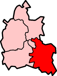
The middle level is South Oxfordshire District Council. The district council has responsibility for matters such as housing, planning and waste collection. The district is divided into 19 wards for the elections of councillors. Crowmarsh ward, which comprises the parishes of Crowmarsh, Ipsden and Nuffield, elects one councillor to the forty-eight member authority.[6]
The upper tier of local government is Oxfordshire County Council, which administers "wide area" strategic services such as education, highways and social services. Crowmarsh forms part of the Benson electoral division, returning one councilor to the 74 member body.[7]
External links
- "Crowmarsh". Oxfordshire Wildlife and Landscape Study. Oxfordshire County Council. 2004. http://owls.oxfordshire.gov.uk/wps/wcm/connect/OWLS/Home/Oxfordshire+Districts/Oxfordshire+Districts+-+Parishes/South+Oxfordshire+Parishes/Crowmarsh/. Retrieved 15 November 2009.[dead link]
- "Crowmarsh Parish Appraisal". 2004. http://www.crowmarshsurvey.org.uk/. Retrieved 15 November 2009.
Crowmarsh Gifford Community Site
References
- Pedgley, B; Pedgley, D (1990). Crowmarsh – A history of Crowmarsh Gifford, Newnham Murren, Mongewell and North Stoke. Crowmarsh History Group. ISBN 0951630504.
- ^ "Parish Headcounts". 2001 Census: Neighbourhood Statistics. United Kingdom: Office for National Statistics. http://www.neighbourhood.statistics.gov.uk/dissemination/LeadTableView.do?a=3&b=798638&c=crowmarsh&d=16&e=15&g=480805&i=1001x1003x1004&m=0&r=1&s=1258304820530&enc=1&dsFamilyId=779. Retrieved 15 November 2009.
- ^ Ministry of Health Order No.76241
- ^ "Table B. Areas altered between 26th April 1931 and 30th June 1932, showing constitution as at the latter date in terms of constitution as at the former date, together with particulars of acreage and population (A.C., M.B.s, U.D.s, R.D.s and C.P.s)". Census of England and Wales, 1931. County of Oxford (Part II). HMSO. 1933. p. 10. http://histpop.org/ohpr/servlet/Download/0287_00010_00010.tif.zip. Retrieved 15 November 2009.
- ^ "Parish Council Details: Crowmarsh". South Oxfordshire District Council. http://www.southoxon.gov.uk/ccm/members/ParishDetails.jsp?id=20. Retrieved 15 November 2009.
- ^ "Parish Council". Crowmarsh Gifford Community Site. http://www.crowmarshgifford.org.uk/parish-council.php?it=1. Retrieved 15 November 2009.
- ^ "The District of South Oxfordshire (Electoral Changes) Order 2001 (S.I.2002/49)". Office of Public Sector Information. 20 December 2001. http://www.opsi.gov.uk/si/si2002/uksi_20020049_en.pdf. Retrieved 15 November 2009.
- ^ "County Councillors". Oxfordshire County Council. http://www.oxfordshire.gov.uk/wps/portal/publicsite/doitonline/finditonline/councillorscommittees?order_by_string=electoral_division&page=aboutyourcouncil.councillors. Retrieved 15 November 2009.
Coordinates: 51°35′N 1°06′W / 51.58°N 1.10°W
Categories:- Oxfordshire geography stubs
- Civil parishes in Oxfordshire

Wikimedia Foundation. 2010.