- Matachewan, Ontario
-
Matachewan — Township — 
Motto: Where the highway ends... the adventure begins! 
 Matachewan
Coordinates: 48°00′N 80°39′W / 48°N 80.65°WCoordinates: 48°00′N 80°39′W / 48°N 80.65°W Country  Canada
Province  Ontario
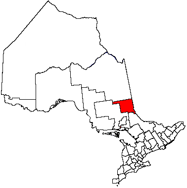
District Timiskaming Established Incorporated Government – Type Township – Reeve Beverley Hine – Federal riding Timmins—James Bay – Prov. riding Timiskaming—Cochrane Area[1] – Land 543.63 km2 (209.9 sq mi) Population (2006)[1] – Total 375 – Density 0.7/km2 (1.8/sq mi) Time zone EST (UTC-5) – Summer (DST) EDT (UTC-4) Postal Code P0K 1M0 Area code(s) 705 Website www.matachewan.com Matachewan is a small township in Timiskaming, northeastern Ontario, Canada, located at the end of Ontario Highway 66 along the Montreal River.
The town's main economy is based on mineral mining, mainly gold mining, with some tourism.
Contents
History
Matachewan began as a trading post of the Hudson's Bay Company, called Fort Matachewan, located about 8 kilometres (5.0 mi) north of the present town site. It consisted only of a large depot and stores, with a church added later on. The local First Nations, who traded their furs here, would camp along the Montreal River but not settle permanently.[2]
The impetus to the town's growth came in the 1920s when mineral deposits, such as gold, copper, and molybdenite, were found in the area. From then on it experienced boom and bust cycles of typical mining towns, depending on the swings in commodity prices, but its economy has gradually shifted to forestry and tourism. They have also built a new bridge that goes over the Montreal River in 2008.[2]
Demographics
Population trend:[3]
- Population in 2006: 375 (2001 to 2006 population change: 21.8 %)
- Population in 2001: 308
- Population in 1996: 402
- Population in 1991: 453
Private dwellings, excluding seasonal cottages: 166 (total: 217)
 Matachewan as seen across the Montreal River.
References
- ^ a b Statistics Canada 2006 Census
- ^ a b "About Matachewan". Township of Matachewan. http://www.matachewan.com/about.html. Retrieved 2009-07-31.[dead link]
- ^ Statistics Canada: 1996, 2001, 2006 census
External links
City 
Towns Townships Armstrong • Brethour • Casey • Chamberlain • Charlton and Dack • Coleman • Evanturel • Gauthier • Harley • Harris • Hilliard • Hudson • James • Kerns • Larder Lake • Matachewan • McGarryVillage ThornloeIndian Reserves MatachewanUnorganized areas East • WestSee also: Communities in Timiskaming District • Census divisions of OntarioCategories:- Municipalities in Timiskaming District, Ontario
- Township municipalities in Ontario
- Northern Ontario geography stubs


Wikimedia Foundation. 2010.