- OL postcode area
-
Coordinates: 53°32′28″N 2°07′05″W / 53.541°N 2.118°W
Oldham postcode area 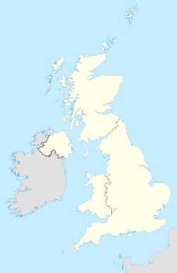
 OL
OLPostcode area OL Postcode area name Oldham Post towns 7 Postcode districts 17 Postcode sectors 68 Postcodes (live) 13,311 Postcodes (total) 16,591 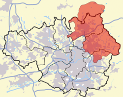
Statistics as at October 2006 [1] The OL postcode area, also known as the Oldham postcode area,[2] is a group of postcode districts around Ashton-under-Lyne, Bacup, Heywood, Littleborough, Oldham, Rochdale and Todmorden in England.
Whilst including almost all of Oldham and most of the wider Metropolitan Borough of Oldham, it is not exclusive to these areas, extending into most of the Metropolitan Borough of Rochdale and parts of the Tameside borough of Greater Manchester, and through a very small part of both Lancashire and West Yorkshire.
Contents
Coverage
The approximate coverage of the postcode districts are:
Postcode district Post town Coverage Local authority area OL1 OLDHAM Chadderton, Higginshaw, Oldham Oldham OL2 OLDHAM Heyside, Royton, Shaw Oldham OL3 OLDHAM Delph, Denshaw, Diggle, Dobcross, Greenfield, Uppermill Oldham OL4 OLDHAM Austerlands, Grasscroft, Grotton, Lees, Lydgate, Oldham, Scouthead, Springhead, Waterhead Oldham OL5 ASHTON-UNDER-LYNE Mossley, Mossley Cross Tameside OL6 ASHTON-UNDER-LYNE Ashton-under-Lyne Tameside OL7 ASHTON-UNDER-LYNE Ashton-under-Lyne Tameside OL8 OLDHAM Bardsley, Oldham Oldham OL9 OLDHAM Chadderton, Oldham, Westwood Oldham OL10 HEYWOOD Heywood Rochdale OL11 ROCHDALE Ashworth, Balderstone, Castleton, Norden, Rochdale Rochdale OL12 ROCHDALE Buckley, Facit, Great Howarth, Healy, Hurstead, Rochdale, Shawforth, Wardle, Whitworth Rochdale OL13 BACUP Bacup, Britannia, Stacksteads Rossendale OL14 TODMORDEN Cornholme, Todmorden, Eastwood, Walsden Calderdale OL15 LITTLEBOROUGH Littleborough, Shore, Smithybridge, Summit Rochdale OL16 ROCHDALE Burnedge, Firgrove, Hurstead, Milnrow, Rochdale, Smallbridge, Thornham Rochdale OL95 OLDHAM Oldham Oldham Adjacent areas
Adjacent postcode areas BB HX 
BL  OL
OL 
HD 
M SK S Clockwise from the east, the adjacent postcode areas are: HD (Huddersfield), S (Sheffield), SK (Stockport), M (Manchester), BL (Bolton), BB (Blackburn), HX (Halifax).
See also
References
- ^ "National Statistics Postcode Directory" (PDF). Office for National Statistics Postcode Directory (November 2006). Office for National Statistics. November 2006. http://www.statistics.gov.uk/geography/downloads/NSPDVersionNotes.pdf. Retrieved 2009-05-29.
- ^ Royal Mail, Address Management Guide, (2004)
Postcode areas in the United Kingdom, Channel Islands and Isle of Man AB AL B BA BB BD BH BL BN BR BS BT BX CA CB CF CH CM CO CR CT CV CW DA DD DE DG DH DL DN DT DY E EC EH EN EX FK FY G GIR GL GU GY HA HD HG HP HR HS HU HX IG IM IP IV JE KA KT KW KY L LA LD LE LL LN LS LU M ME MK ML N NE NG NN NP NR NW OL OX PA PE PH PL PO PR RG RH RM S SA SE SG SK SL SM SN SO SP SR SS ST SW SY TA TD TF TN TQ TR TS TW UB W WA WC WD WF WN WR WS WV YO ZE
Related lists: Postal counties · Post towns · Postcode districts · London postal district Categories:- Oldham
- Tameside
- Rochdale
- Calderdale
- Postcode areas covering North West England


Wikimedia Foundation. 2010.