- Chokhatauri
-
Chokhatauri
ჩოხატაური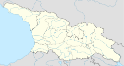
 Chokhatauri
Coordinates: 42°1′3″N 42°15′20″E / 42.0175°N 42.25556°ECoordinates: 42°1′3″N 42°15′20″E / 42.0175°N 42.25556°E Country  Georgia
Region Guria District Chokhatauri Elevation 235 m (771 ft) Time zone UTC+4 Area code(s) +995 Chokhatauri (Georgian: ჩოხატაური) is a town in Georgia’s Guria region, 310 km west to the nation’s capital of Tbilisi. It is an administrative center of Chokhatauri raioni (district), which comprises the town itself and its adjoining 60 villages. The area of the district is 824 km2; population – 24,090 (2002).
Several historical monuments are scattered across the district, e.g. an early medieval fortress of Bukistsikhe, and a monastic complex of Udabno.
Near the town is a health resort based on the natural mineral water Nabeglavi, which is similar to Borjomi in its chemical composition. Bakhmaro is another nearby mountain resort that is famous for its unique wooden cottages on stilts in the mist of the mountains. Nabeglavi mineral water and Bakhmaro spring water are bottled by Healthy Water Ltd. in Chokhatauri.
Villages in the district
Villages in the Chokhatauri district include: Bukistsikhe, Chaisubani, Chokhatauri,Dablatsikhe, Didivani, Erketi, Ganakhleba, Gogolesubani, Goraberezhouli, Guturi, Khevi, Khidistavi, Kokhnari, Kvenobani,Nabeghlavi,Partskhma, Sachamiaseri, Shuaganakhleba, Shuasurebi, Vazimleti, Zemosurebi, Zoti, Zemokheti,
References
- "Ch'okhatauri, Georgia Page". Falling Rain Genomics. http://www.fallingrain.com/world/GG/0/Chokhatauri.html.
- "District of Chokhatauri". ethnia.org. http://www.ethnia.org/ethnia-fiche.php?ask=GE-GE-KT-GU-CK.
- [1]
Cities and towns in Georgia Autonomous Republic of Abkhazia Sokhumi · Akhali Atoni · Gagra · Gali · Gudauta · Ochamchire · Tkvarcheli · Bichvinta · Gantiadi · Gulripshi · Leselidze · Miusera.
Autonomous Republic of Adjara Guria Imereti Kakheti Mtskheta-Mtianeti Samegrelo-Zemo Svaneti Samtskhe-Javakheti Akhaltsikhe · Akhalkalaki · Borjomi · Ninotsminda · Vale · Abastumani · Adigeni · Akhaldaba · Aspindza · Bakuriani · Bakurianis Andeziti · Tsagveriacha-Lechkhumi and Kvemo Svaneti Kvemo Kartli Shida Kartli Cities with local Government Capital City Categories:- Cities and towns in Guria
- Georgia (country) geography stubs


Wikimedia Foundation. 2010.