- Hornsby Shire
Infobox Australian Place | type = lga
name = Hornsby Shire
state = nsw
caption =
pop = 155,971
density = 338
area = 462
est =
seat = Hornsby
mayor = Nick Berman (2004)
region = Metropolitan Sydney
url = http://www.hornsby.nsw.gov.au/
stategov = Hornsby, Hawkesbury, Epping, Castle Hill, Ku-ring-gai
fedgov = Berowra, Bennelong, Bradfield
near-nw =City of Hawkesbury
near-n =City of Gosford
near-ne =City of Gosford
near-e =Warringah Council
near-w =Baulkham Hills Shire
near-sw =City of Parramatta
near-s =City of Ryde
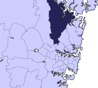
near-se =Ku-ring-gai Council Hornsby Shire is a vast Local Government Area in the Northern region of
Sydney ,Australia . The estimated population of Hornsby Shire as of June 2003 was 155,971 (Australian Bureau of Statistics ).The followings are the suburbs of Hornsby Shire
Hornsby Shire's suburbs stretches from Eastwood in the south to Wisemans Ferry in the north
Suburbs of the local government area
Suburbs in Hornsby Shire are:
* Arcadia
* Asquith
* Beecroft
* Berowra
* Berowra Heights
* Berowra Waters
* Berrilee
* Brooklyn
* Canoelands
* Carlingford (shared withBaulkham Hills Shire andCity of Parramatta )
* Castle Hill (shared withBaulkham Hills Shire )
* Cheltenham
* Cherrybrook
* Cowan
* Dural (shared withBaulkham Hills Shire )
* Epping (shared withCity of Parramatta )
* Fiddletown
* Forest Glen
* Galston
* Glenhaven (shared withBaulkham Hills Shire )
* Glenorie (shared withBaulkham Hills Shire )
* Hornsby
* Hornsby Heights
* Kangaroo Point
* Laughtondale
* Maroota
* Middle Dural
* Milsons Passage
* Mount Colah
* Mount Ku-ring-gai
* Normanhurst
* North Epping
* Pennant Hills
* Round Corner
* Thornleigh
* Wahroonga (shared withKu-ring-gai Council )
* Waitara
* Westleigh
* West Pennant Hills (shared withBaulkham Hills Shire )
* Wisemans FerryLocalities of the local government area
Localities in Hornsby Shire include:
* Bobbin Head
* Collingridge Point
*Dangar Island
* Fishermans Point
* Hookhams Corner
* Long Island
* Roselea
* Singletons Mill
* Thompsons CornerHistory
Hornsby Shire was originally occupied by the Dharug and Ku-ring-gai tribes of
Indigenous Australians . While the northern part of the Shire (via theHawkesbury River ) was visited by the first European settlers in late 1788, due to the Shire's rugged landscape permanent European settlement did not begin until almost half a century later.Hornsby Shire got its name from the town of Hornsby at the eastern end of the Shire, is derived from
Convict -turned-Constable Samuel Hornsby, who earned distinction by capturingbushranger s Dalton and MacNamara onJune 22 ,1830 . In return he was granted land in the locality known as "Hornsby Place".Hornsby Shire has remained largely rural for many decades. The construction of the Northern Railway Line (see
Cityrail ) in the 1880s opened up the Shire to the rest of Sydney and also to Newcastle, but it was not until motor vehicles became commonplace in the 1950s that the southern part of the Shire truly became part of Sydney's suburbia.Geography
Hornsby calls itself the 'Bushland Shire'. This is in reference to its location on a high ridge separating two expansive areas of natural bushland: The
Ku-ring-gai Chase National Park on the eastern side and theBerowra Valley Regional Park on the western side. These provide large areas of natural parkland that form agreenbelt running from Sydney at the south to theHawkesbury River at the Shire's northern end. These parks are extremely popular with day-trippers from all areas of Sydney and provides diverse recreations such as bushwalking and boating.The northern half of Hornsby Shire remains a semi-rural area, retaining a number of farmlands and market gardens. The village of Galston is the centre of this rural area.
The southern half of the Shire is urban, forming part of Sydney's suburbia. Traditionally most of the Shire's residents live in free-standing houses, but in recent years a number of semi-detached housings as well as high-density apartments have appeared around the town of Hornsby.
The Shire has two industrial areas, in Hornsby and Thornleigh. The major commercial centres of Shire are the town of Hornsby; the suburbs of Pennant Hills, Epping, and Carlingford.
Local attractions in the Hornsby Shire include its easily accessible wilderness areas, many parkland recreational facilities such as Fagan Park at Galston and Pennant Hills Park, and
Koala Park Sanctuary , a popular tourist attraction inWest Pennant Hills , and the village of Brooklyn on theHawkesbury River .Infrastructure
Transport
The urban areas of Hornsby is serviced by two railway lines (the Northern Line and the North Shore Line) of the
CityRail network.The "Northern Line" forms an arc which begins at the
Sydney central business district (CBD), going through the Inner Western suburbs, turns north and enters the Hornsby Shire at its south-western end, heading north-east to the town of Hornsby, then proceeds northward to the city of Newcastle and beyond.The "North Shore Line" begins at the central business district, crossing theSydney Harbour Bridge and passing through North Sydney, then proceeds northward until terminating at the town Hornsby.Because Hornsby Shire is somewhat deficient in bus transports, its residents typically rely heavily on family motor vehicles. Moreover, being the northern gateway of Sydney means that thousands of heavy trucks pass through Hornsby Shire every day and night. The main roads within the Shire are the F3 Freeway (which is managed federally), running from the Wahroonga northward to the city of Newcastle; the Pacific Highway, running from Wahroonga southward to the CBD; the
Pennant Hills Road (part of Cumberland Highway), running from Hornsby westward to Parramatta; and part of the M2 tollway.Education
Hornsby Shire has numerous schools, both government and private. Government schools can either be selective or comprehensive; private schools are typically run by Catholic, Anglican, or non-denominational Christian groups. Single-sex schools are somewhat more common in Hornsby Shire than in other parts of Sydney. Regardless of the type of school, however, their academic results are generally above that of the state average. Because Hornsby Shire is often seen as a desirable place to raise schoolchildren, even comprehensive government schools can have long waiting lists.
There is also a
TAFE College at the town of Hornsby.Hospitals
Hornsby Ku-ring-gai Hospital at the town of Hornsby is the main public hospital for the Upper North Shore. There are a number of private hospitals in the nearby area including theSydney Adventist Hospital which is a major hospital serving the North Shore Region, which is actually located in the adjacent Municipality of Ku-ring-gai.Other facilities
Hornsby Shire has five public libraries, three public swimming pools ("Aquatic Centres"), and a range of other sporting and community facilities.The conservative councillors on the current Council have also pushed successfully for a horse riding facility costing over $10 million to be built in the sparsely populated rural side of the Council Fact|date=April 2007.
Politics
The Hornsby Shire Council (established in 1906) is the local government authority of Hornsby Shire. The Council consists of nine councillors (three for each of the three "wards" of approximately equal population), plus a popularly-elected mayor, all elected for a four-year term. Traditionally, "independent" councillors who had close ties with the
Liberal Party of Australia dominated the Council; however the current Council (elected in 2004) has three councillors from theAustralian Labor Party (A Ward: Janelle McIntosh, B Ward: Mark Lyons, C Ward: Jan Dekker), plus one from theAustralian Greens (A Ward: Wendy McMurdo). Of the remaining councillors, two are conservative independents, and four areLiberal Party of Australia members (including the serving Mayor, Nick Berman).Hornsby Shire is divided between the
New South Wales state electorates of Hornsby, Castle Hill and Epping, while federally it lies within the electorate of Berowra. These have always been "safe" Liberal seats; the current FederalAustralian House of Representatives member for Berowra isPhilip Ruddock , who, while considered a controversial figure by many Australians, is well-supported by the largely centre-right residents of the Berowra Electorate. The state electorate of Hornsby was considered more marginal after the departure of former state member Stephen O'Doherty. Judy Hopwood, the current state member for Hornsby increased the margin on which she held the seat at the recent 2007 state election.External links
* [http://www.abs.gov.au/ausstats/abs@census.nsf/Lookup2001Census/4A329CFD91D21B2DCA256BBE0083C55D 2001 Census Information]
Hornsby Shire will be, in forthcoming elections, divided into two wards each of five councillors who will be in addition to the popularly elected Mayor.
Wikimedia Foundation. 2010.