- Lima
-
This article is about the capital of Peru. For other uses, see Lima (disambiguation).
Lima View of Lima District from the San Cristobal hill.

Flag
SealNickname(s): City of Kings Motto: Hoc signum vere regum est Lima Province and Lima within Peru
Coordinates: 12°2′36″S 77°1′42″W / 12.04333°S 77.02833°WCoordinates: 12°2′36″S 77°1′42″W / 12.04333°S 77.02833°W Country Peru Region Lima Region Province Lima Province Districts 43 districts Government - Type Mayor–council government - Mayor Susana Villarán Area - City 2,672.3 km2 (1,031.8 sq mi) - Urban 800 km2 (308.9 sq mi) - Metro 2,819.3 km2 (1,088.5 sq mi) Elevation 0–1,548 m (0–5,079 ft) Population (2007)[1] - City 7,605,742 - Density 2,846.1/km2 (7,371.4/sq mi) - Metro 8,472,935 - Metro density 3,008.7/km2 (7,792.5/sq mi) - Demonym Limean (Spanish: Limeño/a) Time zone PET (UTC-5) Website www.munlima.gob.pe Lima is the capital and largest city of Peru. It is located in the valleys of the Chillón, Rímac and Lurín rivers, in the central part of the country, on a desert coast overlooking the Pacific Ocean. Together with the seaport of Callao, it forms a contiguous urban area known as the Lima Metropolitan Area. With a population fast approaching 9 million, Lima is the fifth largest city in Latin America, behind Mexico City, São Paulo, Buenos Aires and Rio de Janeiro. Lima is home to one of the largest financial hubs in Latin America. It has been defined as a beta world city by GaWC international ranking.
Lima was founded by Spanish conquistador Francisco Pizarro on January 18, 1535, as la Ciudad de los Reyes, or "the City of Kings". It became the capital and most important city in the Spanish Viceroyalty of Peru. Following the Peruvian War of Independence, it became the capital of the Republic of Peru. Today, around one-third of the Peruvian population lives in the metropolitan area.
Lima is home to one of the oldest higher learning institutions in the New World. The National University of San Marcos, founded on May 12, 1551 during Spanish colonial regime, is the oldest continuously functioning university in the Americas.
Contents
Etymology
According to early Spanish chronicles the Lima area was once called Itchyma, after its original inhabitants. However, even before the Inca occupation of the area in the 15th century, a famous oracle in the Rímac valley had come to be known by visitors as limaq (limaq, pronounced [ˈlimɑq], which means "talker" in coastal Quechua). This oracle was eventually destroyed by the Spanish and replaced with a church, but the name persisted in the local language, thus the chronicles show "Límac" replacing "Ychma" as the common name for the area.[2]
Modern scholars speculate that the word "Lima" originated as the Spanish pronunciation of the native name Limaq. Linguistic evidence seems to support this theory as spoken Spanish consistently rejects stop consonants in word-final position. The city was founded in 1535 under the name City of the Kings (Spanish: Ciudad de los Reyes) because its foundation was decided on January 6, date of the feast of the Epiphany. Nevertheless, this name quickly fell into disuse and Lima became the city's name of choice; on the oldest Spanish maps of Peru, both Lima and Ciudad de los Reyes can be seen together as names for the city.
It is worth noting that the river that feeds Lima is called Rímac, and many people erroneously assume that this is because its original Inca name is "Talking River" (the Incas spoke a highland variety of Quechua where the word for "talker" was pronounced [ˈrimɑq]).[citation needed] However, the original inhabitants of the valley were not the Incas, and this name is actually an innovation arising from an effort by the Cuzco nobility in colonial times to standardize the toponym so that it would conform to the phonology of Cuzco Quechua. Later, as the original inhabitants of the valley died out and the local Quechua became extinct, the Cuzco pronunciation prevailed. In modern times, Spanish-speaking locals do not see the connection between the name of their city and the name of the river that runs through it. They often assume that the valley is named after the river; however, Spanish documents from the colonial period show the opposite to be true.[2]
History
Main article: History of Lima Pachacamac was an important religious centre before the arrival of Spanish conquistadors
In the pre-Columbian era, the location of what is now the city of Lima was inhabited by several Amerindian groups under the Ychsma polity, which was incorporated into the Inca Empire in the 15th century.[3] In 1532, a group of Spanish conquistadors led by Francisco Pizarro defeated the Inca ruler Atahualpa and took over his Empire. As the Spanish Crown had named Pizarro governor of the lands he conquered,[4] he chose the Rímac valley to found his capital on January 18, 1535 as Ciudad de los Reyes (City of the Kings).[5] In August 1536, rebel Inca troops led by Manco Inca besieged the city but were defeated by the Spaniards and their native allies.[6]
Lima gained prestige after being designated capital of the Viceroyalty of Peru and site of a Real Audiencia in 1543.[7] During the next century it flourished as the centre of an extensive trade network which integrated the Viceroyalty with the rest of the Americas, Europe and the Far East.[8] However, the city was not free from dangers; the presence of pirates and privateers in the Pacific Ocean lead to the building of the Lima City Walls between 1684 and 1687.[9] Also in this last year a powerful earthquake destroyed most of the city buildings;[10] the earthquake marked a turning point in the history of Lima as it coincided with a recession in trade and growing economic competition with other cities such as Buenos Aires.[11]
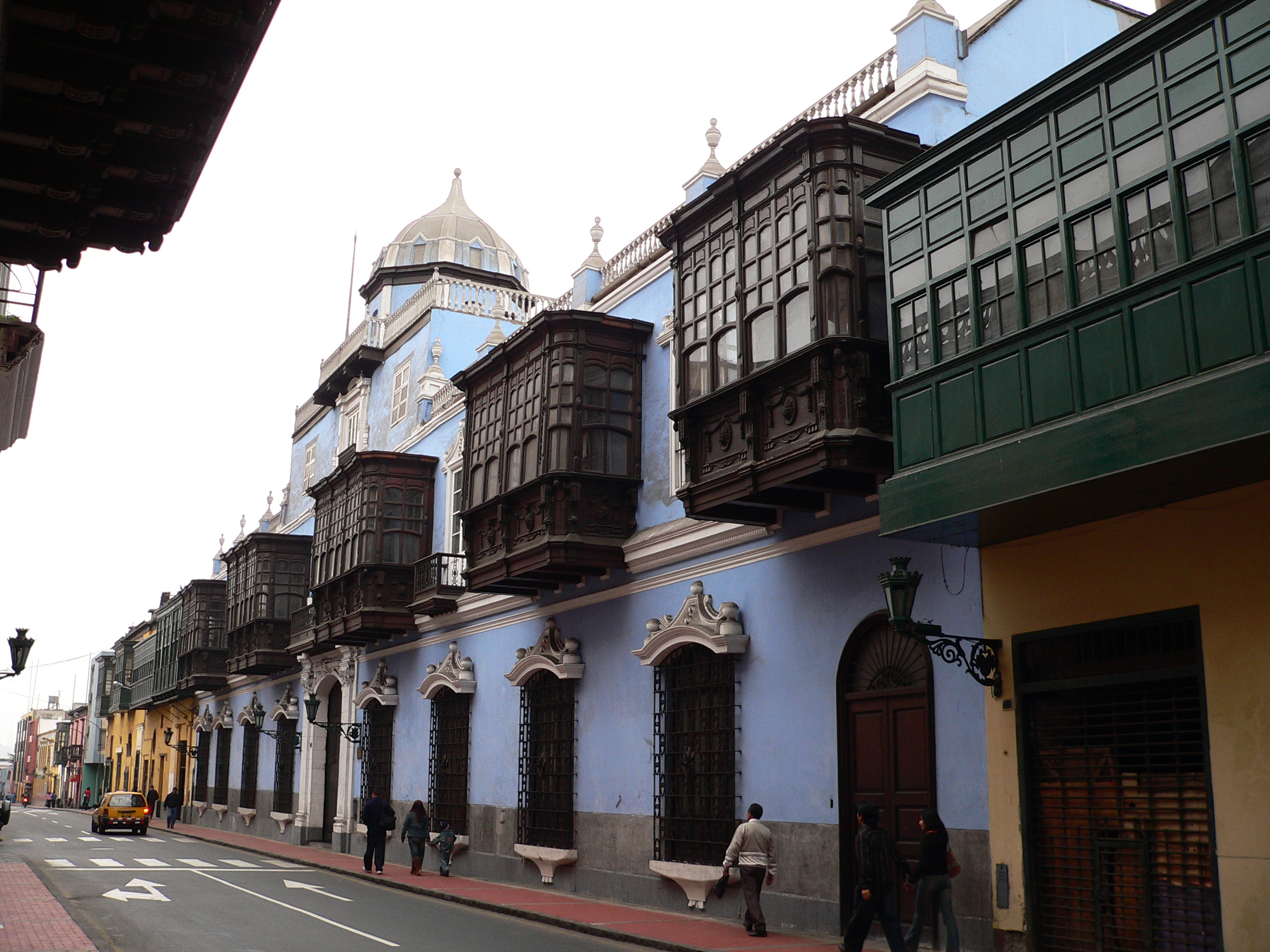
 Balconies were a major feature of Lima's architecture during the colonial period.
In 1746, a powerful earthquake severely damaged Lima and destroyed Callao, forcing a massive rebuilding effort under Viceroy José Antonio Manso de Velasco.[12] In the later half of the 18th century, Enlightenment ideas on public health and social control shaped the development of the city.[13] During this period, Lima was adversely affected by the Bourbon Reforms as it lost its monopoly on overseas trade and its control over the important mining region of Upper Peru.[14] The city's economic decline made its elite dependent on royal and ecclesiastical appointment and thus, reluctant to advocate independence.[15]
A combined expedition of Argentine and Chilean patriots under General José de San Martín managed to land south of Lima in 1820 but did not attack the city. Faced with a naval blockade and the action of guerrillas on land, Viceroy José de la Serna was forced to evacuate its capital on July 1821 to save the Royalist army.[16] Fearing a popular uprising and lacking any means to impose order, the city council invited San Martín to enter Lima and signed a Declaration of Independence at his request.[17] However, the war was not over; in the next two years the city changed hands several times and suffered exactions from both sides.

After independence, Lima became the capital of the Republic of Peru but economic stagnation and political turmoil brought urban development to a halt. This hiatus ended in the 1850s, when increased public and private revenues from guano exports led to a rapid development of the city.[18] The export-led expansion also widened the gap between rich and poor, fostering social unrest.[19] During the 1879–1883 War of the Pacific, Chilean troops occupied Lima, looting public museums, libraries and educational institutions.[20] At the same time, angry mobs attacked wealthy citizens and the Asian population; sacking their properties and businesses.[21] After the war, the city underwent a process of renewal and expansion from the 1890s up to the 1920s. During this period, the urban layout was modified by the construction of big avenues that crisscrossed the city and connected it with neighboring towns.[22]
In 1940, an earthquake destroyed most of the city, which at that time was mostly built of adobe and quincha. In the 1940s, Lima started a period of rapid growth spurred by migration from the Andean regions of Peru, as rural people sought better opportunities for work and education. The population, estimated at 0.6 million in 1940, reached 1.9M by 1960 and 4.8M by 1980.[23] At the start of this period, the urban area was confined to a triangular area bounded by the city's historic centre, Callao and Chorrillos; in the following decades settlements spread to the north, beyond the Rímac River, to the east, along the Central Highway, and to the south.[24] The new migrants, at first confined to slums in downtown Lima, led this expansion through large-scale land invasions, which evolved into shanty towns, known as pueblos jóvenes.[25]
Geography
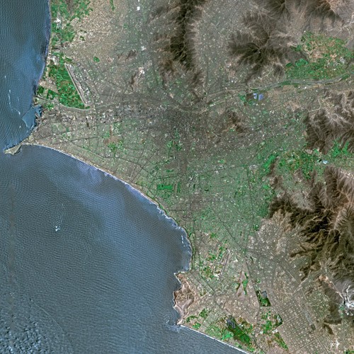
 Lima seen from SPOT satellite
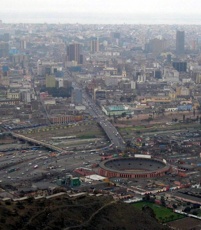
The urban area of Lima covers about 800 km2 (310 sq mi). It is located on mostly flat terrain in the Peruvian coastal plain, within the valleys of the Chillón, Rímac and Lurín rivers. The city slopes gently from the shores of the Pacific Ocean into valleys and mountain slopes located as high as 500 metres (1,600 ft) above mean sea level. Within the city there are isolated hills which are not connected to the surrounding hill chains, such as El Agustino, San Cosme, El Pino, La Milla, Muleria and Pro hills. The San Cristobal hill in the Rimac district, which lies directly north of the downtown area, is the local extreme of an Andean hill outgrowth.
Metropolitan Lima has an area of 2,672.28 km2 (1,031.77 sq mi), of which 825.88 km2 (318.87 sq mi) (31%) comprise the actual city and 1,846.40 km2 (712.90 sq mi) (69%) the city outskirts.[citation needed] The urban area extends around 60 km (37 mi) from north to south and around 30 km (19 mi) from west to east. The city center is located 15 km (9.3 mi) inland at the shore of the Rimac river, a vital resource for the city, since it carries what will become drinking water for its inhabitants and fuels the hydroelectric dams that provide electricity to the area. While no official administrative definition for the city exists, it is usually considered to be composed of the central 30 out of the 43 districts of Lima Province, corresponding to an urban area centered around the historic Cercado de Lima district.[citation needed] The city is the core of the Lima Metropolitan Area, one of the ten largest metropolitan areas in the Americas. Lima is the second largest city in the world located in a desert, after Cairo, Egypt.
Climate
 Weather averages for Lima International Airport.
Lima's climate is mild and comfortable, despite being located in the subtropics and in a desert. Although classified as subtropical, Lima's proximity to the cool waters of the Pacific Ocean leads to temperatures much cooler than those expected for a subtropical desert, and can be classified as a cool desert climate. It is neither cold nor very hot. Temperatures rarely fall below 12 °C (54 °F) or rise above 29 °C (84 °F) throughout the entire year. Two distinct seasons can be identified: summer, from December through April; and winter from June through October. May and November are generally transition months, with the warm-to-cool weather transition being more dramatic.
Summers are warm, humid and sunny. Daily temperatures oscillate between lows of 18 °C (64 °F) to 22 °C (72 °F), and highs of 24 °C (75 °F) to 29 °C (84 °F). Skies are generally cloud free, especially during daytime. Occasional coastal fogs during some mornings and high clouds during some afternoons and evenings can be present. Lima summer sunsets are well known for being colorful. As such, they have been labeled by the locals as "cielo de brujas" (Spanish for "sky of witches"), since the sky commonly turns into shades of orange, pink and red around 7 pm. Winter weather is dramatically different. Gray skies, breezy conditions, high humidity and cool temperatures prevail. Long (1-week or more) stretches of dark overcast skies are not uncommon. Persistent morning drizzle occurs occasionally from June through September, coating the streets with a thin layer of water that generally dries up by early afternoon. Winter temperatures in Lima do not vary much between day and night. They range from lows of 12 °C (54 °F) to 16 °C (61 °F) and highs of 16 °C (61 °F) to 19 °C (66 °F), rarely exceeding 20 °C (68 °F) except in the easternmost districts.[26]
Relative humidity is always very high, particularly in the mornings.[26] High humidity produces brief morning fog during the early summer and a usually persistent low cloud deck during the winter (generally developing in May and persisting all the way into late November or even early December). Predominant onshore flow makes the Lima area one of the cloudiest among the entire Peruvian coast. Lima has only 1284 hours of sunshine a year, 28.6 hours in July and 179.1 hours in January, exceptionally low values for the latitude.[27] Winter cloudiness prompts locals to seek for sunshine in Andean valleys located at elevations generally above 500 meters above sea level.
Although relative humidity levels are high, rainfall is very low due to strong atmospheric stability. The severely low rainfall impacts on water supply in the city, which originates from wells and from rivers that flow from the Andes.[28] Inland districts receive anywhere between 1 to 6 cm (2.4 in) of rainfall per year, which accumulates mainly during the winter months. Coastal districts receive only 1 to 3 cm (1.2 in). As previously mentioned, winter precipitation occurs in the form of persistent morning drizzle events. These are locally called 'garúa', 'llovizna' or 'camanchacas'. Summer rain, on the other hand, is infrequent, and occurs in the form of isolated light and brief showers. These generally occur during afternoons and evenings when leftovers from Andean storms arrive from the east. The lack of heavy rainfall arises from high atmospheric stability caused, in term, by the combination of cool waters from semi-permanent coastal upwelling and the presence of the cold Humboldt Current; and warm air aloft associated with the South Pacific anticyclone.
The climate of Lima (as that of most of the Peruvian coast) gets severely disrupted during El Niño events. Water temperatures along the coast, which usually average around 17–19 °C (63–66 °F), get much warmer (as in 1998 when the water temperature reached 26 °C (79 °F)). Air temperatures rise accordingly. Such was the case when Lima hit its all-time record high of 34 °C (93 °F).[26] Cooler climate develops during La Niña years. The all-time record low in the metropolitan area is 8 °C (46 °F), measured during the winter of 1988.[26]
Climate data for Lima Month Jan Feb Mar Apr May Jun Jul Aug Sep Oct Nov Dec Year Average high °C (°F) 25.8
(78.4)26.5
(79.7)26.0
(78.8)24.3
(75.7)21.7
(71.1)19.7
(67.5)18.7
(65.7)18.4
(65.1)18.7
(65.7)19.9
(67.8)21.9
(71.4)23.9
(75.0)22.1 Average low °C (°F) 19.1
(66.4)19.4
(66.9)19.2
(66.6)17.6
(63.7)16.1
(61.0)15.3
(59.5)15.0
(59.0)14.6
(58.3)14.6
(58.3)15.2
(59.4)16.4
(61.5)17.7
(63.9)16.7 Precipitation mm (inches) 0.9
(0.035)0.3
(0.012)4.9
(0.193)0
(0)0.1
(0.004)0.3
(0.012)0.3
(0.012)0.3
(0.012)5.4
(0.213)0.2
(0.008)0
(0)0.3
(0.012)13.0
(0.512)Source: World Meteorological Organisation (UN)[29] Demographics
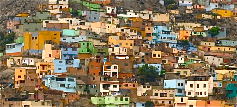
Main article: Demographics of Lima Slums in the outskirts of Lima.
With a municipal population of 7,605,743, and 8,472,935 for the metropolitan area and a population density of 3,008.8 inhabitants per square kilometre (7,793 /sq mi) as of 2007,[1] Lima ranks as the 27th most populous 'agglomeration' in the world.[30] Its population features a very complex mix of racial and ethnic groups. Mestizos of mixed Amerindian and European (mostly Spanish and Italians) ancestry are the largest ethnic group. European Peruvians are the second largest group. Many are of Spanish, Italian or German descent; many others are of French, British, or Croatian descent.[31][32] The minorities in Lima include Amerindians (mostly Aymara and Quechua), Afro-Peruvians, whose African ancestors were initially brought to the region as slaves, are yet another part of the city's ethnic diversity. There are also numerous Jews of European descent and Middle Easterners. Asians make up a large number of the metropolitan population, especially of Chinese (Cantonese) and Japanese descent, whose ancestors came mostly in the 19th and early 20th centuries. Lima has, by far, the largest ethnic Chinese community in Latin America.[33]
 High rise apartments.
The first settlement in what would become Lima was made up of only 117 housing blocks. In 1562, another district was built at the other side of the Rimac River and in 1610, the first stone bridge was built. Lima then had a population of around 26,000; blacks made up around 40% of the population, and whites made up around 38% of the population.[34] By 1748, the white population totaled 16,000–18,000.[35] In 1861, the number of inhabitants surpassed 100,000, and by 1927, this amount was doubled.[citation needed]
During the early twentieth century, thousands of immigrants came to the city, including a significant number of French, Italians and Germans, many of whom have assimilated to the Peruvian society. They organized in social clubs, and they built their own schools; for example, The American-Peruvian school which is located in Miraflores; the French Alliance (Alianza Francesa de Lima), the notable Lycée Franco-Péruvien and the hospital Maison de Sante;; the British-Peruvian school in Monterrico and also several German-Peruvian schools. They influenced Peruvian cuisine, the Italians in particular exerting a strong influence in the Miraflores and San Isidro areas with their restaurants, called trattorias.[citation needed]
A great number of Chinese immigrants, and a lesser amount of Japanese, came to Lima and established themselves in the Barrios Altos neighborhood near downtown Lima. Lima residents refer to their Chinatown as Calle Capon, and the city's ubiquitous Chifa restaurants – a small, sit-down, usually Chinese-run restaurant serving the Peruvian spin on Chinese cuisine – can be found by the dozen in this Chinese enclave.
Economy
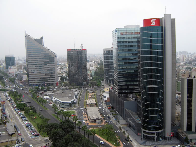
 Financial center of the city in San Isidro.
Lima is the industrial and financial center of Peru, and one of the most important financial centers in Latin America.[36] Today it is home to many national companies. It accounts for more than two thirds of Peru's industrial production[37] and most of its tertiary sector.
The Metropolitan area, with around 7000 factories,[38] spearheads the industrial development of the country, thanks to the quantity and quality of the available workforce, cheap infrastructure and the mostly developed routes and highways in the city. The most relevant industrial sectors are textiles, clothing and food. Chemicals, fish, leather and oil derivatives are also manufactured and/or processed in Lima.[38] The financial district is located in the district of San Isidro, while much of the industrial activity takes place in the area stretching west of downtown Lima to the airport in Callao. Lima has the largest exportation industry in South America, and it is a regional hub for the operational cargo industry.
Industrialization began to take hold in Lima in 1930s and by 1950s, through import substitution policies, by 1950 manufacturing made up 14% of the GNP. In the late 1950s, up to 70% of consumer goods were manufactured in factories located in Lima.[39]
The Callao seaport is one of the main fishing and commerce ports in South America, with 75% of the country's imports and 25% of its exports[40] using it as their entry/departure point. The main export goods leaving the country through Callao are oil, steel, silver, zinc, cotton, sugar and coffee. Lima generates 53% of the GDP of Peru. In 2010, GDP per capita in Lima reached $20,000.[41] Most of the foreign companies operating in the country have settled in Lima, which has led to the previously mentioned concentration of economic and financial activity on the city.
There has been a noticeable increase in light industries, services and high technologies. In 2007, the Peruvian economy grew 9%, the largest growth rate in all of South America which was spearheaded by economic policies originating in Lima.[42] The Lima Stock Exchange grew 185.24% in 2006[43] and in 2007 grew 168.3%,[44] making it one of the fastest growing stock exchanges in the world. In 2006, the Lima Stock Exchange was the most profitable in the world.[45] The unemployment rate in the metropolitan area is 7.2%.
The Asia-Pacific Economic Cooperation Summit and the Latin America, the Caribbean and the European Union Summit were hosted by the city of Lima.
Lima is headquarters to many major banks such as Banco de Crédito del Perú, Interbank, Bank of the Nation, Banco Continental, MiBanco, Banco Interamericano de Finanzas, Banco Finaciero, Banco de Comercio, and Credi Scotia. It is also a regional headquarters to Standard Chartered. Major insurance coorperations based in Lima include Rimac Seguros, Mapfre Peru, Interseguro, Pacifico, Protecta, and La Positiva.[46]
Government
National government
 Municipal palace of Lima
Lima is the capital city of the Republic of Peru and the department of Lima. As such, it is home to the three branches of the Government of Peru. The executive branch is headquartered in the Government Palace, located in the Plaza Mayor. The legislative branch is headquartered in the Legislative Palace and is home to the Congress of Peru. The Judicial branch is headquartered in the Palace of Justice and is home to the Supreme Court of Peru. Likewise, all the ministries are located in the city of Lima. In international government, the city of Lima is home to the headquarters of the Andean Community of Nations and the South American Community of Nations, along with other regional and international organizations.
The Palace of Justice in Lima is seat of the Supreme Court of Justice the highest judicial court in Peru with jurisdiction over the entire territory of Peru. Lima is also seat of two of the 28 second highest or Superior Courts of Justice. The first and oldest Superior Court in Lima is the Superior Court of Justice of Lima belonging to the Judicial District of Lima. Due to the judicial organization of Peru, the highest concentration of courts is located in Lima despite the fact that its judicial district only has jurisdiction over 35 of the 43 districts of Lima.[47] The Superior Court of the Cono Norte is the second Superior Court located in Lima and is part of the Judicial District of North Lima. This judicial district has jurisdiction over the remaining eight districts all located in northern Lima.[48]
Local government
Main article: Metropolitan Municipality of LimaThe city is roughly equivalent to the Province of Lima, which is subdivided into 43 districts. The Metropolitan Municipality of Lima is utmost authority of the entire city while each district has its own local government. Unlike the rest of the country, the Metropolitan Municipality, although a provincial municipality, acts as and has functions similar to a regional government, as it does not belong to any of the 25 regions of Peru.
Cityscape
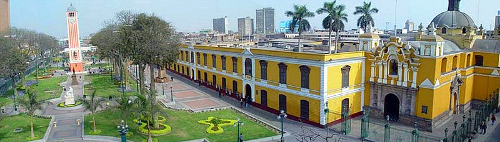
 Church of San Francisco
Lima's architecture is characterized by a mix in styles as reflected from shifts between trends throughout various time periods of the city's history. Examples of early colonial architecture include such structures as the Monastery of San Francisco, the Cathedral of Lima and the Torre Tagle Palace. These constructions are generally influenced by the Spanish baroque,[49] Spanish Neoclassicism,[50] and Spanish Colonial[51] styles. After independence, a gradual shift towards the neoclassical and Art Nouveau styles took place. Many of these constructions were greatly influenced by French architectural styles.[52] Many government buildings as well as major cultural institutions were contracted in this architectural time period. During 1960s, constructions utilizing the brutalist style began appearing in Lima due to the military government of Juan Velasco.[53] Examples of this architecture include the Museum of the Nation and the Ministry of Defense. The 21st century has seen the appearance of glass skyscrapers, particularly around the city's financial district.[54] Also there are several new architectural and real estate projects.[55]
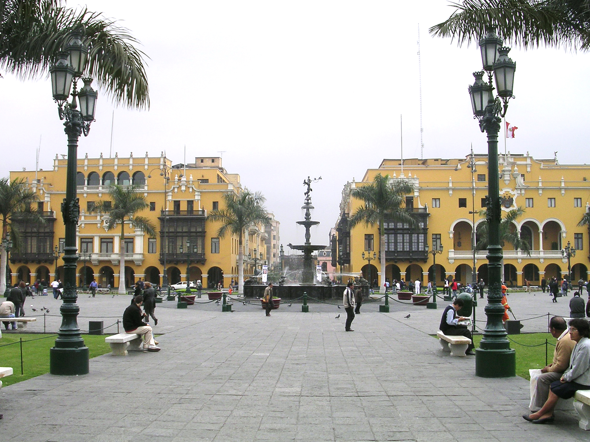
The largest parks of Lima are located near the downtown area such as the Park of the Reserve, Park of the Exposition,[56] Campo de Marte, and the University Park. The Park of the Reserve is home to the largest fountain complex in the world known as the Magical Circuit of Water.[57] A number of large parks lie outside the city center, including Reducto Park, Pantanos de Villa, El Golf (San Isidro), Parque de las Leyendas (Lima Zoo), El Malecon de Miraflores, and the Golf Los Incas.[58] The street grid of the city of Lima, is laid out with a system of plazas of which serve a purpose similar to roundabouts or junctions. In addition to this practical purpose, plazas serve as one of Lima's principal green spaces and contain a variety of different types of architecture ranging from monuments to statues, and water fountains.[59]
Society and culture
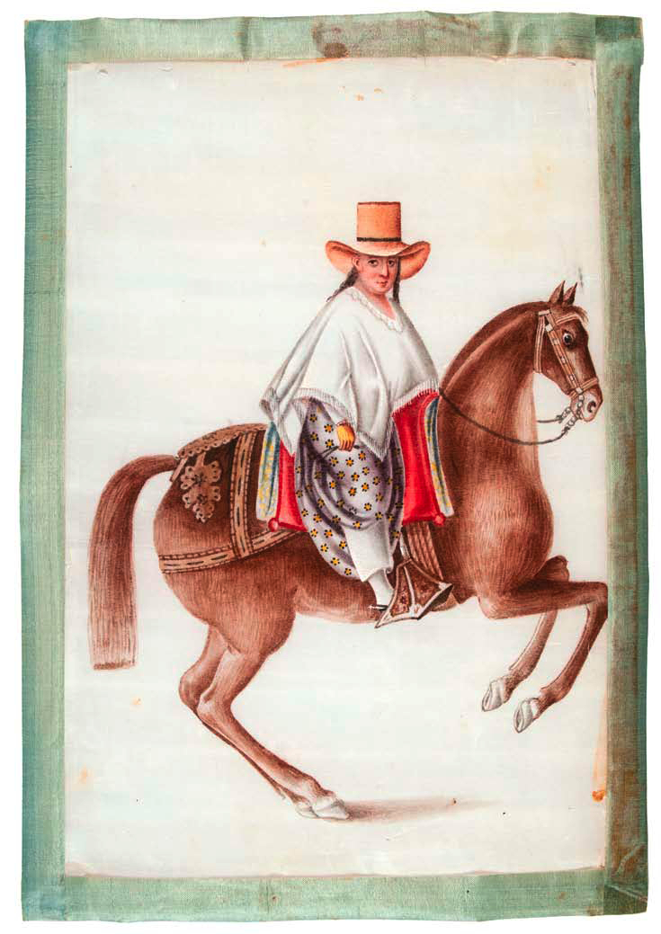
 Woman in White Poncho on Horseback. Cantonese watercolor, sold in Lima mid-19th century. These paintings were copies of works of Francisco Fierro, a popular Afro-Peruvian artist of the time. Collections of the Museum of International Folk Art, Santa Fe.
Strongly influenced by European, Andean, African and Asian culture, Lima is a melting pot of cultures due to colonization, immigration, and indigenous influences.[60] The Historic Center of Lima was declared a UNESCO World Heritage Site in 1988. Like many other world capitals, Lima is home to prestigious museums, many of which are world renowned.
Limean cuisine is known to be among the best in the world, and the city is known as the Gastronomical Capital of the Americas. Lima's gastronomy is a mix of Spanish, Andean, and Asian culinary traditions.[61]
Lima's beaches, located along the northern and southern ends of the city, are heavily visited during the summer months. Numerous restaurants, clubs and hotels have been opened in these places to serve the many beachgoers. Lima has a vibrant and active theater scene, as there are many theaters presenting not only classic theater, but also cultural presentations, modern theater, experimental theater, dramas, dance performances, and theater for children. Lima is home to many important theaters, such as the Municipal Theater, Segura Theater, Japanese-Peruvian Theater, Marsano Theater, British theater, Theater of the PUCP Cultural Center, and the Yuyachkani Theater.[62]
Language
Known as Peruvian Coastal Spanish, Lima's Spanish is characterized by the lack of strong innotations as found in many other regions of the Spanish-speaking world. It is heavily influenced by the historical Spanish spoken in Castile. Throughout the colonial era, most of the Spanish colonial nobility based in Lima were originally from Castile.[63] Limean Spanish is also characterized by the lack of voseo, a trait present in the dialects of many other Latin American countries. This is because voseo was primarily used by the lower socioeconomic classes of Spain, a social group that did not begin to appear in Lima until the late colonial era[citation needed].
Limean Spanish is distinguished by its relative clarity in comparison to other Latin American accents. Limean Spanish has been influenced by a number of immigrant groups including Italians, Andalusians, Chinese and Japanese. It also has been influenced by anglicisms as a result of globalization, as well as by Andean Spanish, due to the recent migration from the Andean highlands to Lima.[64]
Museums
Main article: Museums in LimaLima is home to the highest concentration of museums of the country, the most notable of which are the Museo Nacional de Arqueología Antropología e Historia del Perú, Museum of Art of Lima, the Museum of Natural History, the Museum of the Nation, The Sala Museo Oro del Perú Larcomar, the Museum of Italian Art, and the Museum of Gold, and the Larco Museum. These museums mostly focus on art, pre-Columbian cultures, natural history, science and religion.[65] There's a particularity with the Museum of Italian Art, which is the only museum that shows European art in Peru.
Tourism
Main article: Tourism in LimaHistoric Centre of Lima * UNESCO World Heritage Site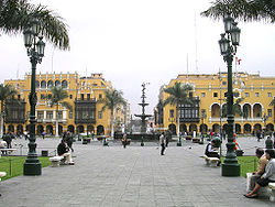
Country Peru Type Cultural Criteria iv Reference 500 Region ** Latin America and the Caribbean Inscription history Inscription 1988 (12th Session) Extensions 1991 * Name as inscribed on World Heritage List
** Region as classified by UNESCOAs the major point of entry to the country, Lima has developed an important tourism industry, characterized by its historic center, archeological sites, nightlife, museums, art galleries, festivals, and popular traditions. Lima is home to an ample range of restaurants and bars where local as well as international cuisine is served.[66]
The Historic Center of Lima, made up of the districts of Lima and Rimac, was declared a World Heritage Site by UNESCO in 1988 due to its importance during the colonial era leaving a testimony to architectural achievement.[67] Some examples of this historical colonial architecture include the Monastery of San Francisco, the Plaza Mayor, the Cathedral, Covenant of Santo Domingo, the Palace of Torre Tagle, and much more.
A tour of the city's churches is a popular circuit among tourists. A short jaunt through the central district goes through many churches dating from as early as the 16th and 17th centuries, the most noteworthy of which are the Cathedral of Lima and the Monastery of San Francisco, said to be connected by their subterrestrial catacombs.[68] Both of these churches contain paintings from various schools of art, Sevilian tile, and finely sculpted wood furnishings.
Also notable is the Sanctuary of Las Nazarenas, the point of origin for the Lord of Miracles, whose festivities in the month of October constitute the most important religious event in Lima, and a major one of Peru. Some sections of the Lima City Walls still remain and are frequented by tourists. These examples of medieval Spanish fortifications were built to defend the city from attacks by pirates and privateers.[69] Beaches are visited during the summer months, which are located along the Pan-American Highway, to the south of the city in districts such as Lurin, Punta Hermosa, Santa María del Mar (Peru), San Bartolo and Asia. Many restaurants, nightclubs, lounges, bars, clubs, and hotels have developed in said places to cater to beachgoers.[70]
The suburban districts of Cieneguilla, Pachacamac, and the city of Chosica, are important tourist attractions among locals. Because they are located at a higher elevation than Lima, they receive more sunshine in winter months, something that the city of Lima frequently lacks under seasonal fog.[71]
Food
Main article: Peruvian cuisineLima is known as the Gastronomical Capital of the Americas. A center of immigration and the center of the Spanish Viceroyalty, Lima has incorporated unique dishes brought from the arrival of the Spanish conquistadors and many waves of immigrants: African, European, Chinese, and Japanese.[61] Besides international immigration—a large portion of which happened in Lima—there has been, since the second half of the 20th century, a strong internal flow from rural areas to cities, in particular to Lima.[72] This has strongly influenced Lima's cuisine with the incorporation of the immigrant's ingredients and techniques (for example, the Chinese extensive use of rice or the Japanese approach to preparing raw fish). The genres of restaurants in Lima include Creole food, Chifas, Cebicherias, and Pollerias. Peruvian cuisine, widely represented in Lima, holds various Guinness World Records, for its diversity and quality.[73]
Sports
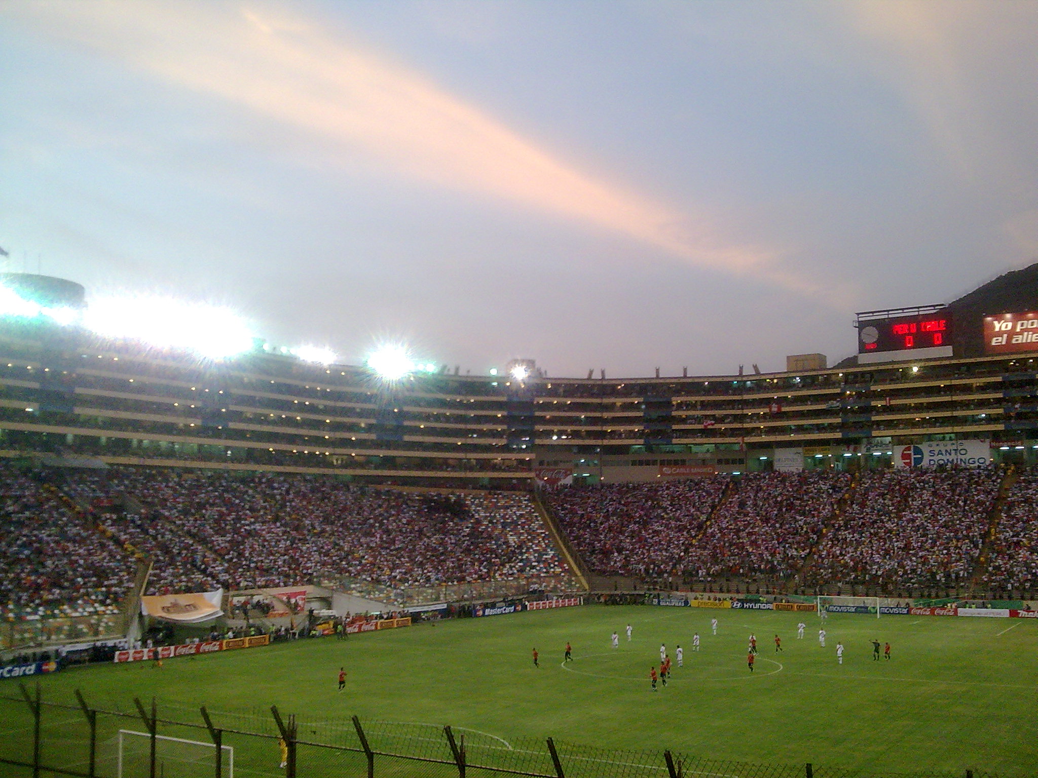
Main article: Sport in Lima The Estadio Monumental "U" during a match of Peruvian National Soccer Team.
The city of Lima has varied sports venues for football, volleyball and basketball, many of which are located within private clubs. A popular sport among Limeans is fronton, a racquet sport similar to squash invented in Lima. The city is home to seven international-class golf links. Equestrian is popular in Lima with many private clubs as well as the Hipódromo de Monterrico horse racing track. The most popular sport in Lima by far is football with many professional club teams being located in the city.
The Historic Plaza de Acho, located in the Rimac district a few minutes from the Plaza de Armas, holds bullfights yearly. The season typically runs from late October to December.
Club Sport League Venue Peruvian Institute of Sport Various Various Estadio Nacional (Lima) Universitario de Deportes Football Primera División Peruana Monumental "U" Stadium Alianza Lima Football Primera División Peruana Alejandro Villanueva Stadium Sporting Cristal Football Primera División Peruana San Martín de Porres Stadium Universidad San Martín de Porres Football Primera Division Peruana San Martín de Porres Stadium Club de Regatas Lima Various Various Regatas Headquarters Chorrillos Real Club Lima Basketball, Volleyball Various San Isidro Subdivisions
Main article: List of districts of LimaLima is made up of thirty densely-populated districts, each headed by a local mayor and the Mayor of Lima, whose authority extends to these and the thirteen outer districts of the Lima province.
The city's historic centre is located in the Cercado de Lima district, locally known as simply Lima, or as "El Centro" ("Downtown"), and it is home to most of the vestiges of Lima's colonial past, the Presidential Palace (Spanish: Palacio de Gobierno), the Metropolitan Municipality of Lima (Spanish: Consejo municipal metropolitano de Lima), and dozens of hotels, some operating and some defunct, that used to cater to the national and international elite.
The upscale San Isidro district is the city's financial center. It is home to many prominent figures such as politicians and celebrities. It is also where the main banks of Peru and branch offices of world banks are headquartered. San Isidro has many parks, including Parque El Olivar, which has olive trees that were brought from Spain during the seventeenth century.
Another upscale district is Miraflores, which has many luxury hotels, shops and restaurants. Miraflores has more parks and green areas in the south of Lima than most other districts. Larcomar, a popular shopping mall and entertainment center built on cliffs overlooking the Pacific Ocean, featuring bars, dance clubs, movie theaters, cafes, shops, boutiques and galleries, is also located in this district. Nightlife, shopping and entertainment also center around Parque Kennedy, a park in the heart of Miraflores that is always bustling with people and live performances.[75]
La Molina, San Borja and Santiago de Surco, home to the American Embassy and the exclusive Club Polo Lima, are the other three wealthy districts of Lima.
The most densely-populated districts of Lima lie in the northern and southern ends of the city (Spanish: Cono Norte and Cono Sur, respectively), and they are mostly composed of Andean immigrants who arrived during the mid and late 20th century looking for better living standards and economic opportunities, or as refugees of the country's internal conflict with the Shining Path during the late 80s and early '90s. In the case of Cono Norte (now called Lima Norte), certain shopping malls like Megaplaza and Royal Plaza have been recently built in the Independencia district, right on the border with the Los Olivos district, the latter being the most residential neighborhood in the Northern part of Lima. Most of the inhabitants of this area belong to the middle class or lower middle class.
Barranco, which borders Miraflores by the Pacific Ocean, is known as the city's bohemian district, home or once home of many Peruvian writers and intellectuals like Mario Vargas Llosa, Chabuca Granda and Alfredo Bryce Echenique. This district has many acclaimed restaurants, music venues called "peñas" featuring the traditional folk music of coastal Peru (in Spanish, "música criolla"), and beautiful Victorian-style chalets. It along with Miraflores serves as the home to the foreign nightlife scene.
Education
Lima is home to the oldest higher learning institution in the New World, San Marcos University founded in 1551. Home to a range of universities, institutions, and schools, Lima has the highest concentration of institutions of higher learning in the continent and is home to schools with worldwide recognition. Peru itself is one of the most educated countries in South America. The National University of San Marcos, founded on May 12, 1551 during Spanish colonial regime, is the oldest continuously functioning university in the Americas.[76]
Universidad Nacional de Ingeniería (UNI) was founded in 1876 by Polish engineer Eduardo de Habich and is the most important engineering school in the country. Other public universities also play key roles in teaching and research, such as the Universidad Nacional Federico Villarreal (the second largest in the country), the Universidad Nacional Agraria La Molina where ex-president Alberto Fujimori once taught, and the National University of Callao.
The Pontificia Universidad Católica del Perú, established in 1917, is the oldest private university. Other private institutions that are located in the city are Universidad del Pacifico, Universidad de Lima, Universidad San Martín de Porres, Universidad Peruana Cayetano Heredia, Universidad Cientifica del Sur, Universidad San Ignacio de Loyola, Universidad Peruana de Ciencias Aplicadas and Universidad Ricardo Palma.[77]
 View of the Cultural Center of the University of San Marcos, to left side is located the University Park, the Clock University and illustrious monuments of San Marcos; the right side of the historical Casona de San Marcos.
Transport
Main article: Transport in LimaAir transport
Lima is served by the Jorge Chávez International Airport, located in Callao (LIM). It is the largest airport of the country with the largest amount of domestic and international air traffic. It also serves as a major hub in the Latin American air network. Lima's Jorge Chavez International Airport is the fourth largest air hub in South America. The airport, however it is the base for the largest cargo hub in the continent. Additionally, Lima possesses five other airports: the Las Palmas Air Force Base, Collique Airport, and runways in Santa María del Mar, San Bartolo and Chilca.[78]
Land transportation
For more details on this topic, see Highways of Peru.Lima is a major stop on the Pan-American Highway. Because of its location on the country's central coast, Lima is also an important junction in Peru's highway system. Three of the major highways originate in Lima.
- The Northern Panamerican Highway, this highway extends more than 1,330 kilometres (830 mi) to the border with Ecuador connecting the northern districts of Lima with many major cities along the northern Peruvian coast.
- The Central Highway (Spanish: Carretera Central), this highway connects the eastern districts of Lima with many cities in central Peru. The highway extends 860 kilometres (530 mi) with its terminus at the city of Pucallpa near Brazil.
- The Southern Panamerican Highway, this highway connects the southern districts of Lima to cities on the southern coast. The highway extends 1,450 kilometres (900 mi) to the border with Chile.
The city of Lima has one big bus terminus station located next to the mall Plaza norte in the north of the city. This bus station is the point of departure and arrival of a lot of buses with national and international destinations. There are other bus stations for each company around the city. In addition, there are informals bus stations located in the south, center and north of the city; these bus stations are cheap but dangerous and are not recommended for foreigners.
Maritime transport
The proximity of Lima to the port of Callao allows Callao to act as the metropolitan area's foremost port. Callao concentrates nearly all of the maritime transport of the metropolitan area. There is, however, a small port in Lurín whose transit mostly is accounted for by oil tankers due to a refinery being located nearby. Nonetheless, maritime transport inside Lima's city limits is relatively insignificant compared to that of Callao, the nation's leading port and one of Latin America's largest.
Rail transport
Lima is connected to the Central Andean region by the Ferrocarril Central Andino which runs from Lima through the departments of Junin, Huancavelica, Pasco, and Huanuco.[79] Major cities along this line include Huancayo, La Oroya, Huancavelica, and Cerro de Pasco. Another inactive line runs from Lima northwards to the city of Huacho.[80]
Public transport
Eighty percent of the city's history having occurred during the pre-automobile era, Lima's road network is based mostly on large divided avenues rather than freeways. In recent times however, Lima has developed a freeway network now made up of nine freeways which are, the Via Expresa Paseo de la Republica, Via Expresa Javier Prado, Via Expresa Grau, Panamericana Norte, Panamericana Sur, Carretera Central, Via Expresa Callao, Autopista Chillon Trapiche, and the Autopista Ramiro Priale.[81][81]
The urban transport system is composed of over 652 transit routes[45] which are served by buses, microbuses, and combis. The system is unorganized and is characterized by the lack of formality. The service is run by 464 private companies which are poorly regulated by the local government. Fares average at around one sol or $0.30 USD. The city of Lima has also more than 100 km of cycle paths.
Taxis in the city are mostly informal; they are relatively cheap but could be dangerous. There are no meters so drivers are told the desired destination and the fare is agreed upon before the passenger enters the taxi. Taxis vary in sizes from small four door compacts to large vans. They are virtually everywhere, with different colours, accounting for a large part of the car stock. In many cases they are just a private car with a taxi sticker on the windshield. Additionally, there are several companies that provide taxi service on-call.[82]
Automobiles, known as colectivos, render express service on some major roads of the Lima Metropolitan Area. The colectivos signal their specific destination with a sign on the their windshield. Their routes are not generally publicitized but are understood by frequent users. The cost is generally higher than public transport however they cover greater distances at greater speeds due to the lack of stops. This service is informal and is not allowed in the city.[83] Some people in the periphery of the city use the so called "mototaxi" for short distances
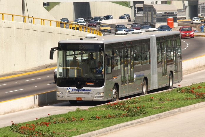
Main article: El Metropolitano Metropolitano articulated buses run on a exclusive lane
The Metropolitan Transportation System or El Metropolitano is a public transportation system which integrate the Independent Corridor of Mass-Transit Buses known by its Spanish initials as (COSAC 1). This system links the principal points of the Lima Metropolitan Area and the first phase of this project has thirty three km line from the north of the city to Chorrillos in the south of the city. It began commercial operations on July 28th, 2010. This system is similar to the TransMilenio of Bogotá, Colombia.[84]
Main article: Lima Metro Train at Villa el Salvador station
The Lima Metro, an above ground mass transit system, which 3rd phase of the Line One is already opened to public. There are six more lines in planning phase. Line 1's extension to the city's center was opened in July 2011, linking Villa el Salvador with downtown Lima in a matter of only thirty minutes, a trip which currently lasts one hour and forty minutes with other public transport system.
The Lima Metro has sixteen passenger stations, located at an average distance of 1.2 km (0.7 mi). It starts its path in the Industrial Park of Villa El Salvador, south of the city, continuing on to Av. Pachacútec in Villa María del Triunfo and then to Av. Los Héroes in San Juan de Miraflores. Afterwards, it continues through Av. Tomás Marsano in Surco to reach Ov. Los Cabitos and then on to Av. Aviación to finish in Av. Grau in the city center. Construction to extend Line 1 until its final destination, through Av. Próceres de la Independencia in San Juan de Lurigancho, is scheduled to begin shortly.
International relations
- Twin towns — Sister cities
 Bordeaux, France. since 1957
 Beijing, China, since November 1983[86]
 Manila, Philippines[87]
 Madrid, Spain[88]
 Mexico City, Mexico
 São Paulo, Brazil[89][90]
 Tegucigalpa, Honduras
 Akhisar, Turkey
- Karaçoban, Turkey
 Buenos Aires, Argentina
- Guadalajara, Mexico
 Toronto, Canada[citation needed]
 Bogotá, Colombia
 Cairo, Egypt
 Cardiff, United Kingdom
 Pescara, Italy
 Kiev, Ukraine
- Brasília, Brazil
See also
- Lima Metropolitan Area
- List of people from Lima
- List of districts and neighborhoods of Lima
- List of sites of interest in the Lima Metropolitan area
- Largest cities in the Americas
Notes
- ^ a b Instituto Nacional de Estadística e Informática, Perfil Sociodemográfico del Perú pp. 29–30, 32, 34.
- ^ a b "Limaq". http://aymara.org/biblio/lima_etimologia.pdf. Retrieved 2009-10-10.
- ^ Conlee et al., "Late Prehispanic sociopolitical complexity", p. 218.
- ^ Hemming, The conquest, p. 28.
- ^ Klarén, Peru, p. 39.
- ^ Hemming, The conquest, p. 203–206.
- ^ Klarén, Peru, p. 87.
- ^ Andrien, Crisis and decline, pp. 11–13.
- ^ Higgings, Lima, p. 45.
- ^ Andrien, Crisis and decline, p. 26.
- ^ Andrien, Crisis and decline, p. 28.
- ^ Walker, "The upper classes", pp. 53–55.
- ^ Ramón, "The script", pp. 173–174.
- ^ Anna, Fall of the royal government, pp. 4–5.
- ^ Anna, Fall of the royal government, pp. 23–24.
- ^ Anna, Fall of the royal government, pp. 176–177.
- ^ Anna, Fall of the royal government, pp. 178–180.
- ^ Klarén, Peru, p. 169.
- ^ Klarén, Peru, p. 170.
- ^ Higgings, Lima, p. 107.
- ^ Klarén, Peru, p. 192.
- ^ Ramón, "The script", pp. 180–182.
- ^ (Spanish) Instituto Nacional de Estadística e Informática, Lima Metropolitana perfil socio-demográfico. Retrieved on August 12, 2007
- ^ Dietz, Poverty and problem-solving, p. 35.
- ^ Dietz, Poverty and problem-solving, p. 36.
- ^ a b c d "Weather Centre – World Weather – Average Conditions – Lima". BBC. http://www.bbc.co.uk/weather/world/city_guides/results.shtml?tt=TT001940. Retrieved 2009-07-08.
- ^ Capel Molina, José J. (1999). "Lima, un clima de desierto litoral". Anales de Geografía de la Universidad Complutense (Madrid: Universidad Complutense de Madrid) 19: 25–45. ISSN 0211-9803. http://revistas.ucm.es/ghi/02119803/articulos/AGUC9999110025A.PDF. Retrieved 2009-10-10
- ^ Painter, James (2007-03-12). "Americas | Peru's alarming water truth". BBC News. http://news.bbc.co.uk/2/hi/americas/6412351.stm. Retrieved 2009-07-08.
- ^ "World Weather Information Service – Lima". http://worldweather.wmo.int/029/c00108.htm.
- ^ United Nations Department of Economic and Social Affairs, Urban Agglomerations 2007. – note, per the source, "Urban agglomerations included in the chart are those of 1 million inhabitants or more in 2007. An agglomeration contains the population within the contours of contiguous territory inhabited at urban levels of residential density without regard to administrative boundaries."
- ^ Baily, Samuel L; Míguez, Eduardo José (2003). Latin America Since 1930. Google Books. ISBN 9780842028318. http://books.google.com/?id=NZQxkfvMJFgC&dq=immigration+to+peru+italians&printsec=frontcover. Retrieved 2010-04-17.
- ^ "The Institute of International Education (IIE)". IIEPassport.org. Archived from the original on June 9, 2008. http://web.archive.org/web/20080609234624/http://www.iiepassport.org/lima.html. Retrieved 2010-04-17.
- ^ ":: Overseas Compatriot Affairs Commission, R.O.C. ::". Ocac.gov.tw. 2004-08-24. http://www.ocac.gov.tw/english/public/public.asp?selno=1163&no=1163&level=B. Retrieved 2009-10-10.
- ^ History of Lima. Lima Info.
- ^ Colonial Lima according to Jorge Juan and Antonio de Ulloa. From Jorge Juan and Antonio de Ulloa, A Voyage to South America (1748).
- ^ Infoplease. Lima. Retrieved on December 8, 2008.
- ^ AttractionGuide. Lima Attractions. Retrieved on December 8, 2008.
- ^ a b "Study Abroad Peru". Study Abroad Domain. http://www.studyabroaddomain.com/Peru.aspx. Retrieved 2009-07-08.
- ^ Bethell, Leslie (1991). Latin America Since 1930. Google Books. ISBN 9780521266529. http://books.google.com/?id=cbhOISlOv3MC&pg=PA389&lpg=PA389&dq=two+thirds+industry+lima. Retrieved 2010-04-17.
- ^ "Callao, Peru – Hutchinson encyclopedia article about Callao, Peru". Encyclopedia.farlex.com. http://encyclopedia.farlex.com/Callao,+Peru. Retrieved 2009-07-08.
- ^ pág. 24.
- ^ https://www.cia.gov/library/publications/the-world-factbook/rankorder/2003rank.html CIA Factbook
- ^ "Bolsa de Valores de Lima" (PDF). Archived from the original on August 8, 2007. http://web.archive.org/web/20070808150533/http://www.bvl.com.pe/english/estadist/dat_infostat_en.pdf. Retrieved 2010-04-17.
- ^ "Bolsa de Valores de Lima". Bolsa de Valores de Lima. Archived from the original on July 14, 2008. http://web.archive.org/web/20080714134300/http://www.bvl.com.pe/publi_infmensuales.html. Retrieved 2009-07-08.
- ^ a b "Republic Of Peru" (PDF). http://www.proinversion.gob.pe/RepositorioAPS/1/0/arc/TEASER_TREN_ELECTRICO/Teaser_Tren_Elec_Ing_21_febrero2008.pdf. Retrieved 2009-07-08.
- ^ "Compañías de Seguros Peru". Oh Perú. http://www.ohperu.com/empresas/seguros.htm. Retrieved 2009-07-08.
- ^ (Spanish) Judicial Power of Peru. Superior Court of Lima. Retrieved 3 December 2008.
- ^ (Spanish) Judicial Power of Peru. Superior Court of North Lima. Retrieved 3 December 2008.
- ^ "Baroque Architecture". Buzzle.com. http://www.buzzle.com/articles/baroque-architecture.html. Retrieved 2009-07-08.
- ^ [1][dead link]
- ^ Story by Cristyane Marusiak / Photos by João Canziani. "Lima, Peru - Travel - dwell.com". Web.archive.org. Archived from the original on 2008-04-07. http://web.archive.org/web/20080407152742/http://www.dwell.com/peopleplaces/travel/15074421.html. Retrieved 2009-10-10.
- ^ "ACAP – The American and Canadian Association of Peru". Acap-peru.org. 2005-12-01. http://www.acap-peru.org/newsletter/2005-09/september2005_13a.htm. Retrieved 2009-07-08.[dead link]
- ^ Bethell, Leslie (1998). A Cultural History of Latin America and Spain. Books.google.com. ISBN 9780521626262. http://books.google.com/?id=fzFSu-QuBx4C&pg=PA382&lpg=PA382&dq=brutalism+in+lima. Retrieved 2010-04-17.
- ^ feedback. "Lima city guide – the social travel guide Lima, Peru – tripwolf travel tips". Tripwolf.com. http://www.tripwolf.com/en/guide/show/7031/Peru/Lima. Retrieved 2009-07-08.
- ^ "Haydee Sangalli Schaerer:: Bienes Raices". Mira Mar Peru. http://www.miramar-peru.com/. Retrieved 2009-07-08.
- ^ "Periodo 1821–1872 – El Palacio y Parque de la Exposición". Arqandina.com. http://www.arqandina.com/pages/p1/f107.htm. Retrieved 2009-07-08.
- ^ "LaRepublica.pe | Jornada de Protestas / Último adiós a Michael Jackson / Rómulo León". Larepublica.com.pe. http://www.larepublica.com.pe/content/view/130942/. Retrieved 2009-07-08.
- ^ "Lima, Peru – Google Maps". Maps.google.com. 1970-01-01. http://maps.google.com/maps?hl=en&q=Lima%2C%20Peru&um=1&ie=UTF-8&sa=N&tab=wl. Retrieved 2009-07-08.
- ^ "Lima (Peru) :: The city layout – Britannica Online Encyclopedia". Britannica.com. http://www.britannica.com/EBchecked/topic/341104/Lima/32251/The-city-layout. Retrieved 2009-07-08.
- ^ Marmon, Johanna. (2009-06-02). "Colonial masterpiece: many who visit Peru come for the journey to ancient Macchu Picchu. But the former colonialand current daycapital city of Lima is an architectural and gastronomic wonderland – Real Estate Home Sales | South Florida CEO | Find Articles at BNET". Findarticles.com. http://findarticles.com/p/articles/mi_m0OQD/is_/ai_111620596. Retrieved 2009-07-08.
- ^ a b Web Design by Avtec Media. "Peruvian Cuisine ~ New Andean ~ Novoandina – Mixtura Restaurant:: The New Andean Cuisine:: Kirkland, Washington: Latin Spanish Peruvian Restaurants". Mixtura.biz. http://www.mixtura.biz/peruvian-cuisine/index.htm. Retrieved 2009-07-08.
- ^ "Theatres in Lima, Peru – LimaEasy (c)". LimaEasy. 2009-06-27. http://www.limaeasy.com/culture/theaters_lima.php. Retrieved 2009-07-08.
- ^ "Articles: Colonial Lima according to Jorge Juan and Antonio de Ulloa". Historical Text Archive. http://historicaltextarchive.com/sections.php?op=viewarticle&artid=113. Retrieved 2009-07-08.
- ^ Kokotovic, Misha (2007). The Colonial Divide in Peruvian Narrative. Books.google.com. ISBN 9781845191849. http://books.google.com/?id=jayN0hV5DDkC&pg=PA124&lpg=PA124&dq=migration+andes+lima. Retrieved 2010-04-17.
- ^ "Information about Peru". Go2peru.com. http://www.go2peru.com/webapp/ilatintravel/articulo.jsp?cod=1998845. Retrieved 2009-07-08.
- ^ "Lima Peru". Go2peru.com. http://www.go2peru.com/lima_travel_guide.htm. Retrieved 2009-07-08.
- ^ "World Heritage Centre – World Heritage List". Whc.unesco.org. http://whc.unesco.org/en/list. Retrieved 2009-07-08.
- ^ "LIMA – Churches in the Historical Centre of Lima Perú". Enjoyperu.com. http://www.enjoyperu.com/peru_travel_tours_information/peru_travel_destinations/peru_lima/lima-peru-churches-lima.html. Retrieved 2009-07-08.
- ^ "Lima – Peru". VirtualPeru.Net. http://www.virtualperu.net/cities_lima.html. Retrieved 2009-07-08.[dead link]
- ^ "in". In-lan.com. http://www.in-lan.com/en/0702/lima_1.html. Retrieved 2009-07-08.[dead link]
- ^ "HowStuffWorks "Geography of Lima"". HowStuffWorks. http://geography.howstuffworks.com/south-america/geography-of-lima.htm. Retrieved 2009-07-08.
- ^ "Peru's revolution in tastes: innovative chefs in Lima are dishing up a fusion of Andean and European cuisines with seasoning from around the world. (01-MAY-06) Americas (English Edition)". Accessmylibrary.com. 2006-05-01. http://www.accessmylibrary.com/coms2/summary_0286-15424982_ITM. Retrieved 2009-07-08.
- ^ "Living Peru". http://filer.livinginperu.com/101reasons.pdf. Retrieved 2009-10-10.
- ^ "Lima Metropolitana: Características de la Pequeńa Empresa y Micro Empresa por Conos y Distritos, 1993–1996". .inei.gob.pe. http://www1.inei.gob.pe/biblioineipub/bancopub/Est/Lib0163/indice.htm. Retrieved 2009-07-08.
- ^ "Parque Kennedy - Miraflores - Top Rated Peru City Parks". Vivatravelguides.com. http://www.vivatravelguides.com/south-america/peru/lima/miraflores/miraflores-activities/parque-kennedy/. Retrieved 2011-09-16.
- ^ "Congreso Nacional de Estudiantes de Literatura 2008 – CONELIT". Proyectoperuanos.org. 2008-11-25. http://www.proyectoperuanos.org/conelit/maps.html. Retrieved 2009-07-08.[dead link]
- ^ "Lima (Peru) – MSN Encarta". Lima (Peru) – MSN Encarta. Encarta.msn.com. http://encarta.msn.com/encyclopedia_761562138/Lima_(Peru).html. Retrieved 2009-07-08.
- ^ "Great Circle Mapper". Gc.kls2.com. http://gc.kls2.com/. Retrieved 2009-07-08.
- ^ "Ferrocarril Central Andino S.A.". Ferrocarrilcentral.com.pe. http://www.ferrocarrilcentral.com.pe/index_.php. Retrieved 2009-07-08.
- ^ "Bandurria – El sitio – Ferrocarril Lima Huacho". Huacho.info. http://www.huacho.info/bandurria/ferrocarril.html. Retrieved 2009-07-08.
- ^ a b "Periodo 1945–1965 – Galería de Fotos y Planos". Arqandina.com. http://www.arqandina.com/pages/p4/f413.htm. Retrieved 2009-07-08.
- ^ "Lima : Planning a Trip: Getting Around". Frommers.com. 2008-07-28. http://www.frommers.com/destinations/lima/2868020156.html. Retrieved 2009-07-08.
- ^ "TAXIS, MOTOTAXIS AND COLECTIVOS, Peru Tourist Information and Travel Guide at". Infohub.com. http://www.infohub.com/destinations/south-america/peru/63504.htm. Retrieved 2009-07-08.
- ^ "El transporte moderno de Lima". Metropolitano. http://www.metropolitano.com.pe/. Retrieved 2009-07-08.
- ^ Sister Cities International, Online Directory: Peru, Americas. Retrieved July 14, 2007.
- ^ "Sister Cities". Beijing Municipal Government. http://www.ebeijing.gov.cn/Sister_Cities/Sister_City/. Retrieved 2009-06-23.
- ^ "Sister Cities of Manila". © 2008–2009 City Government of Manila. http://www.manila.gov.ph/localgovt.htm#sistercities. Retrieved 2009-07-02.
- ^ "Mapa Mundi de las ciudades hermanadas". Ayuntamiento de Madrid. http://www.munimadrid.es/portal/site/munimadrid/menuitem.dbd5147a4ba1b0aa7d245f019fc08a0c/?vgnextoid=4e84399a03003110VgnVCM2000000c205a0aRCRD&vgnextchannel=4e98823d3a37a010VgnVCM100000d90ca8c0RCRD&vgnextfmt=especial1&idContenido=1da69a4192b5b010VgnVCM100000d90ca8c0RCRD. Retrieved 2009-10-10.
- ^ Prefeitura.Sp – Descentralized Cooperation
- ^ "International Relations – São Paulo City Hall – Official Sister Cities". Prefeitura.sp.gov.br. http://www.prefeitura.sp.gov.br/cidade/secretarias/relacoes_internacionais/cidadesirmas/index.php?p=1066. Retrieved 2010-04-17.
References
- Nota etimológica: El topónimo Lima, Rodolfo Cerrón-Palomino, Pontificia Universidad Católica del Perú
- Lima Monumento Histórico, Margarita Cubillas Soriano, Lima, 1996
- History
- Andrien, Kenneth. Crisis and decline: the Viceroyalty of Peru in the seventeenth century. Albuquerque: University of New Mexico Press, 1985. ISBN 0-8263-0791-4
- Anna, Timothy. The fall of the royal government in Peru. Lincoln: University of Nebraska Press, 1979. ISBN 0-8032-1004-3
- Conlee, Christina, Jalh Dulanto, Carol Mackay and Charles Stanish. "Late Prehispanic sociopolitical complexity". In Helaine Silverman (ed.), Andean archaeology. Malden: Blackwell, 2004, pp. 209–236. ISBN 0-631-23400-4
- Dietz, Henry. Poverty and problem-solving under military rule: the urban poor in Lima, Peru. Austin: University of Texas Press, 1980. ISBN 0-292-76460-X
- Hemming, John. The conquest of the Incas. London: Macmillan, 1993. ISBN 0-333-51794-6
- Higgings, James. Lima. A cultural history. Oxford: Oxford University Press, 2005. ISBN 0-19-517891-2
- (Spanish) Instituto Nacional de Estadística e Informática. Lima Metropolitana perfil socio-demográfico. Lima: INEI, 1996.
- Klarén, Peter. Peru: society and nationhood in the Andes. New York: Oxford University Press, 2000. ISBN 0-19-506928-5
- Ramón, Gabriel. "The script of urban surgery: Lima, 1850–1940". In Arturo Almandoz (ed.), Planning Latin America's capital cities, 1850–1950. New York: Routledge, 2002, pp. 170–192. ISBN 0-415-27265-3
- Walker, Charles. "The upper classes and their upper stories: architecture and the aftermath of the Lima earthquake of 1746". Hispanic American Historical Review 83 (1): 53–82 (February 2003).
- Demographics
- (Spanish) Instituto Nacional de Estadística e Informática, Perfil Sociodemográfico del Perú. Lima: INEI, 2008.
- United Nations Department of Economic and Social Affairs, Urban Agglomerations 2007. New York (June 2008).
External links
- (Spanish) Municipality of Lima
- MSN Map
- 1.40 gigapixel image of Lima
- Lima travel guide from Wikitravel
Articles related to Lima Lima and Callao Metropolitan Area Culture · History · Landmarks · Notable people · Mayors · Other elected officials · Transportation Districts Central Lima Breña · La Victoria · Lima · Rimac South Central Lima Barranco · Jesús María · La Molina · Lince · Magdalena · Miraflores · Pueblo Libre ·San Borja · San Isidro · San Miguel · Santiago de Surco · Surquillo Cono Este Ate · Cieneguilla · Chaclacayo · El Agustino · Lurigancho (Chosica) · San Juan de Lurigancho · San Luis · Santa Anita Cono Norte Ancón · Carabayllo · Comas · Independencia · Los Olivos · Puente Piedra · San Martin de Porres · Santa Rosa Cono Sur Chorrillos · Lurín · Pachacamac · Pucusana · Punta Hermosa · Punta Negra · San Bartolo · San Juan de Miraflores · Santa María del Mar · Villa el Salvador · Villa María del Triunfo Callao Bellavista · Callao District · Carmen de la Legua Reynoso· La Perla · La Punta · Ventanilla  Geographic locale
 Peruvian cities with a population of over 100,000
Capitals of South America World's fifty most-populous urban areas Categories:- Cities in Peru
- Lima
- Capitals in South America
- Populated places in the Lima Region
- Populated coastal places in Peru
- Populated places established in 1535


Wikimedia Foundation. 2010.