- Darien (Metro-North station)
-
Darien 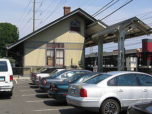
Station statistics Address 33 West Avenue,
Darien, CT 06820Coordinates 41°04′41″N 73°28′23″W / 41.078187°N 73.472958°W Lines Connections CTTransit Stamford: 41, 42 Platforms 2 side platforms Tracks 4 Parking 860 spaces Other information Electrified 12,500V (AC) overhead catenary Accessible 
Traffic Passengers (2006) 351,000[1]  0%
0%Services Preceding station Metro-North Railroad Following station toward Grand CentralNew Haven Line toward New Haven – State StreetThe Darien Metro-North Railroad station serves the residents of Darien, Connecticut via the New Haven Line. It is 37.7 miles from Grand Central Terminal. A small station house is located on the north side of the tracks (New York City-bound side). The station is wheel-chair accessible, with elevators at the east end, near the Boston Post Road.
The station is located downtown at the intersection of the Post Road (U.S. Route 1, the town's main thoroughfare) and West Avenue. A small bus-stop shelter is located on the Boston Post Road at the southeast corner of the station (near the New Haven-bound tracks) for buses going along the Post Road into Stamford. Across the Post Road, buses can be boarded for trips into Norwalk. In the small parking lot around the station house, a Connecticut Transit Stamford bus on Bus Route 42 takes passengers along West Avenue and Glenbrook Road into the Glenbrook section of Stamford. Taxis regularly wait for passengers in the small parking lot adjacent to the New Haven-bound tracks. Entrances and exits to Interstate 95 are on Tokeneke Road (Exit 12) and the Boston Post Road (Exit 11).
Contents
Station parking
Several parking lots on both sides of the tracks serve the station with a total of 860 spaces.[2] The state owns the parking lots nearest the Post Road and on the west (south) side of the tracks between the Post Road and Leroy Avenue (with 195 spaces[3]). The town owns the "Leroy West" parking lot west of Leroy Avenue (toward New York City). The parking lot at the corner of West and Leroy Avenues is privately owned.[2]
Within walking distance
The downtown has a typical variety of retail stores and businesses, with drug stores, banks, restaurants and coffee shops within a 10-minute walk of the station, on either side of the tracks. On the New Haven-bound side of the tracks, Tokeneke Road (Connecticut Route 136) is across the street from the Post Road; and the three-story Darien Library (which moved in late 2008 from Leroy Avenue) is a 10–15 minute walk from the station on the Boston Post Road; small office buildings can be found on Thorndale Circle (near the town library), on Tokeneke Road and Old Kings Highway South, just off of Tokeneke Road, a block from the station. On the New York City-bound side of the tracks, a shopping plaza with a supermarket can be found off of Mechanic Street, the roadway across the Post Road from the station. Tilley Pond Park, with park benches, picnic tables and a covered stone gazebo looking out to the pond, is located across West Avenue.
History
Downtown Darien, originally known as "Darien Depot", grew up around the train station, replacing the Noroton commercial district (2–3 miles to the east, along the Post Road) by the 1870s. By then, the train connection to New York City allowed wealthy New Yorkers to build vacation homes along the shore, beginning Darien's history as a wealthy suburb.[4]
In the 1890s, the railroad tracks were raised above the street level, creating the railroad bridges over the Post Road, which marks the east side of the station, and over Leroy Avenue, at the western end. A Chinese laundry business has been located near the station since the 1890s, operated by various owners.
The historic station building was rehabilitated in 2002. "In general, the station is in good condition with one major exception," according to the January 2007 "Darien Train Station Visual Inspection Report" prepared by the Connecticut Department of Transportation. "Illumination installed under the rehabilitation contract is substandard." The department has reached an agreement with the manufacturer of the lights to replace them.[2]
In recent years the town government of Darien has been collecting parking revenue from the station, which has gone into an improvement fund. As of 2007, the town received revenues of about $100,000 from both stations in Darien.[5]
Platform and track configuration
This station has two high-level side platforms, each 10 cars long. The northern platform, adjacent to Track 3, is generally used by westbound or Manhattan-bound trains. The southern platform, adjacent to Track 4, is generally used by eastbound or outbound trains.
The New Haven Line has four tracks at this location. The two inner tracks, not adjacent to either platform, are used only by express trains.
Gallery
-

Booth at West Avenue parking lot
-

The dark, narrow and low Leroy Avenue underpass
-

View of Tilly Pond Park, across West Avenue
-

West Avenue, near its intersection with the Post Road
See also
- Connecticut Rail Commuter Council is the official state advocate for commuters and brings station problems to the attention of officials.
Notes
- ^ Using 260 weekdays in a year multiplied by number of weekday passengers (1,350)
- ^ a b c [1] Bureau of Public Transportation of the Connecticut Department of Transportation, "Darien Train Station Visual Inspection Report" dated January 2007 (although parts of the inspection were carried out in September 2006)
- ^ [2]"Task 2: Technical Memorandum parking Inventory and Utilization: Final Report" submitted by Urbitran Associates Inc. to the Connecticut Department of Transportation, "Table 1: New haven Line Parking Capacity and Utilization", page 6, July 2003
- ^ "In Search of the Past: A self-Guided Tour of Darien" by Patricia Q. Wall, a 20-page booklet published by the Darien Historical Society in 1986
- ^ Fisher, Joshua (July 19, 2007). "Klein touts record: Won’t say if she’s running (but it sounds like it)". The Darien Times. http://www.acorn-online.com/news/publish/darien/Klein-touts-record-Won-t-say-if-she-s-running-but-it-sounds-like-it_printer.shtml. Retrieved 2007-07-19.[dead link]
External links
Categories:- Darien, Connecticut
- Metro-North Railroad stations in Connecticut
- Stations along New York, New Haven and Hartford Railroad lines
- Railroad stations in Fairfield County, Connecticut
-


Wikimedia Foundation. 2010.