- Deer Park Tavern
-
Deer Park Hotel
 Deer Park Tavern, April 2010
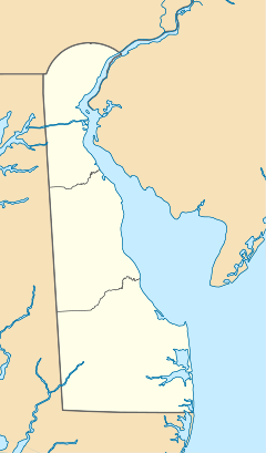

Location: 108 W. Main St., Newark, Delaware Coordinates: 39°40′59″N 75°45′23″W / 39.68306°N 75.75639°WCoordinates: 39°40′59″N 75°45′23″W / 39.68306°N 75.75639°W Area: 0.7 acres (0.28 ha) Built: 1851 Architectural style: Greek Revival Governing body: Private MPS: Newark MRA NRHP Reference#: 82002341[1] Added to NRHP: May 7, 1982 Deer Park Tavern [2] is a historic hotel located at Newark in New Castle County, Delaware. It was built in 1851 on the land where the remains of the burned down St. Patrick's Inn had resided since 1747. It is a 3 1⁄2-story "U"-plan building with nine bays at the south front facade. The building is constructed of wood joists with brick and masonry load bearing walls with Greek Revival elements. It was converted from a hotel in the mid-20th century, and enjoys the college atmosphere of the nearby University of Delaware campus.[3]
The St. Patrick’s Inn was said to house famous historical figures such as George Washington and in 1843 Edgar Allan Poe stayed a night here. The Deer Park logo is based on Poe's classic poem "The Raven".
The first railroad line built through Newark in 1869 is close to the building, and helped to escalate the hotel’s popularity. At this time, The Deer Park was considered one of the finest hotels on the east coast. Much history surrounds the Deer Park including rumors that the basement was used as part of the Underground Railroad during the Civil War.
In 1955, the Amalgamated and Condensed Chemist's Club charter at the University of Delaware's founding chapter was written in the old dining room of the Deer Park. Founders, "in the good old Boswellian tradition", included Carling, LePera, Jordan, Lafferty, Baldwin, Hoffner, Baird, Skinner, deBrabender and Wilson. Today, the patrons include University of Delaware students and staff, business people and locals. The nightly atmosphere varies with bands, DJs and drink specials that bring a hefty crowd each night of the week.
In the 1970s, local bands such as George Thorogood and the Delaware Destroyers played the back room. On October 5, 2010 MSNBC political TV show The Rachel Maddow Show broadcast its show live from the second floor of the Deer Park, which was chosen due to Delaware's upcoming U.S senatorial election. Maddow remarked on her show: "we live for the intersection of politics and beer".
It was added to the National Register of Historic Places in 1982.[1]
References
- ^ a b "National Register Information System". National Register of Historic Places. National Park Service. 2009-03-13. http://nrhp.focus.nps.gov/natreg/docs/All_Data.html.
- ^ Deer Park Tavern
- ^ unknown (undated). "National Register of Historic Places Registration: Deer Park Hotel". National Park Service. http://pdfhost.focus.nps.gov/docs/NRHP/Text/82002341.pdf. Retrieved 2010-04-20.
U.S. National Register of Historic Places Topics Lists by states Alabama • Alaska • Arizona • Arkansas • California • Colorado • Connecticut • Delaware • Florida • Georgia • Hawaii • Idaho • Illinois • Indiana • Iowa • Kansas • Kentucky • Louisiana • Maine • Maryland • Massachusetts • Michigan • Minnesota • Mississippi • Missouri • Montana • Nebraska • Nevada • New Hampshire • New Jersey • New Mexico • New York • North Carolina • North Dakota • Ohio • Oklahoma • Oregon • Pennsylvania • Rhode Island • South Carolina • South Dakota • Tennessee • Texas • Utah • Vermont • Virginia • Washington • West Virginia • Wisconsin • WyomingLists by territories Lists by associated states Other University of Delaware Colleges 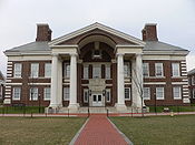
Athletics Colonial Athletic Association • Bob Carpenter Center • Delaware Fight Song • Delaware Stadium • Football (2011 • Coach) • Frazer Field • Fred Rust Ice Arena • Men’s Lacrosse • Men's Soccer • YoUDee
Campus Main campus: Newark
Satellite campuses: Dover • Georgetown • Lewes • Wilmington
Botanic Gardens • Delaware Biotechnology Institute • Disaster Research Center • Energy Institute • Images • University Museums at the University of DelawarePeople Alumni • Faculty • Patrick T. Harker (President) • Police
Student life Deer Park Tavern • Emergency Care Unit • Figure Skating Club • Greek life • The Lamplighter • The Review • Mainstreet Journal • Petal and Thorn • WVUD
Other Categories:- Hotels on the National Register of Historic Places in Delaware
- Restaurants in Delaware
- Taverns in the United States
- University of Delaware
- Hotels in Delaware
- Newark, Delaware
- Railway hotels in the United States


Wikimedia Foundation. 2010.