- Orinoco
-
For other uses, see Orinoco (disambiguation).
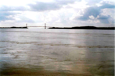
Orinoco River Río Orinoco River  Bridge over the Orinoco at Ciudad Bolívar, Venezuela
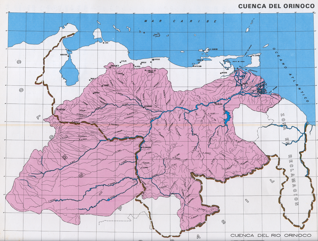
Countries Venezuela, Colombia District South America Source - location Cerro Delgado-Chalbaud, Parima, Venezuela & Brazil - elevation 1,047 m (3,435 ft) - coordinates 02°19′05″N 63°21′42″W / 2.31806°N 63.36167°W Mouth Delta Amacuro - location Atlantic Ocean, Venezuela - elevation 0 m (0 ft) - coordinates 8°37′N 62°15′W / 8.617°N 62.25°W [1] Length 2,140 km (1,330 mi) Basin 880,000 km2 (339,770 sq mi) Discharge - average 33,000 m3/s (1,165,384 cu ft/s)  Orinoco's watershed
The Orinoco is one of the longest rivers in South America at 2,140 km (1,330 mi). Its drainage basin, sometimes called the Orinoquia, covers 880,000 square kilometres (340,000 sq mi), with 76.3% of it in Venezuela and the remainder in Colombia. The Orinoco and its tributaries are the major transportation system for eastern and interior Venezuela and the llanos of Colombia.
Contents
History
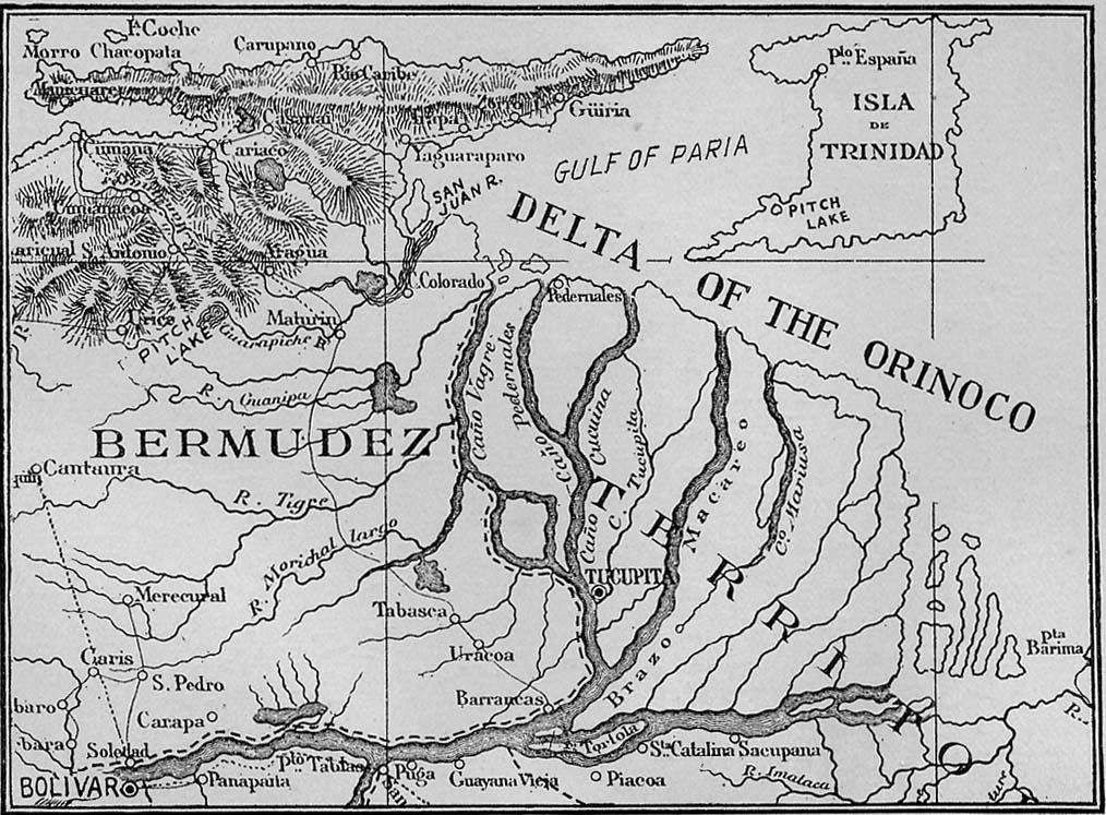
 Map of Lower Orinoco 1897
Although the mouth of the Orinoco in the Atlantic Ocean was documented by Columbus on 1 August 1498, during his third voyage, its source at the Cerro Delgado-Chalbaud, in the Parima range, was first explored in 1951, 453 years later. The source, on the Venezuelan-Brazilian border, at 1,047 m (3,435 ft) of elevation (02°19′05″N 63°21′42″W / 2.31806°N 63.36167°W ), was explored in 1951 by a joint Venezuelan-French team.
The Orinoco delta, and tributaries in the eastern llanos such as the Apure and Meta, were explored in the 16th century by German expeditions under Ambrosius Ehinger and his successors. In 1531 Diego de Ordaz, starting at the principal outlet in the delta, the Boca de Navios, sailed up the river to the Meta, and Antonio de Berrio sailed down the Casanare, to the Meta, and then down the Orinoco and back to Coro.
Alexander von Humboldt explored the basin in 1800, reporting on the pink river dolphins, and publishing extensively on the flora and fauna.[2]
Geography
The course of the Orinoco forms a wide ellipsoidal arc, surrounding the Guiana Shield; it is divided in four stretches of unequal length that roughly correspond to the longitudinal zonation of a typical large river:
- Upper Orinoco— 242 kilometres (150 mi) long, from its headwaters to the rapids Raudales de Guaharibos, flows through mountainous landscape in a northwesterly direction
- Middle Orinoco— 750 kilometres (470 mi) long, divided into two sectors, the first of which ca. 480 kilometres (300 mi) long has a general westward direction down to the confluence with the Atabapo and Guaviare rivers at San Fernando de Atabapo; the second flows northward, for about 270 kilometres (170 mi), along the Venezuelan - Colombian border, flanked on both sides by the westernmost granitic upwellings of the Guiana Shield which impede the development of a flood plain, to the Atures rapids near the confluence with the Meta River at Puerto Carreño,
- Lower Orinoco— 959 kilometres (596 mi) long with a well-developed alluvial plain, flows in a northeast direction, from Atures rapids down to Piacoa in front of Barrancas
- Delta Amacuro— 200 kilometres (120 mi) long that empties into the Gulf of Paría and the Atlantic Ocean, a very large delta, some 22,500 km2 (8,700 sq mi) and 370 kilometres (230 mi) at its widest.
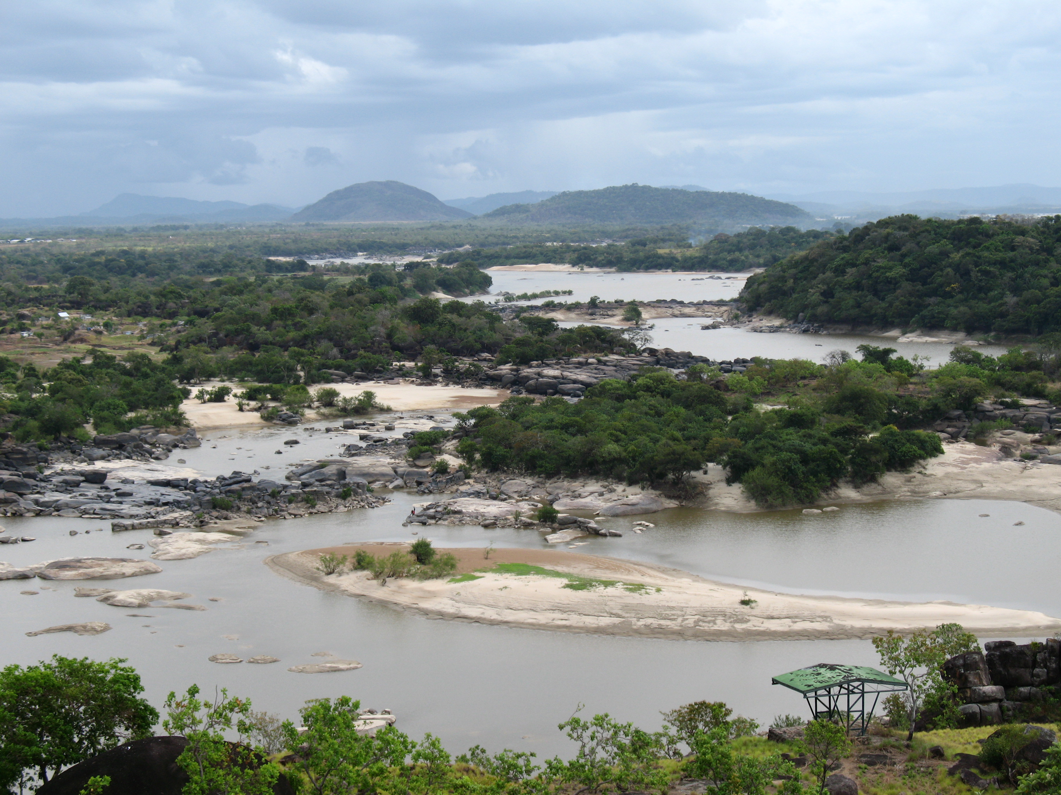
 Panorama of the Orinoco River.
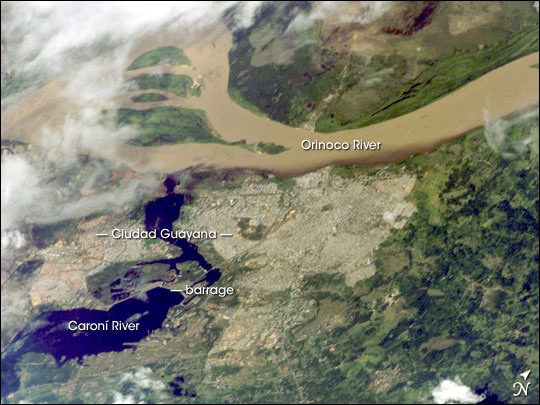
 Orinoco River, the second largest in South America, at its confluence with the Caroní River (lower left).[3]
 Rapids of the Orinoco River, near Puerto Ayacucho airport, Venezuela.
 The Orinoco River, here in Amazonas State, Venezuela.
 Orinoco River, in Amazonas State, Venezuela.
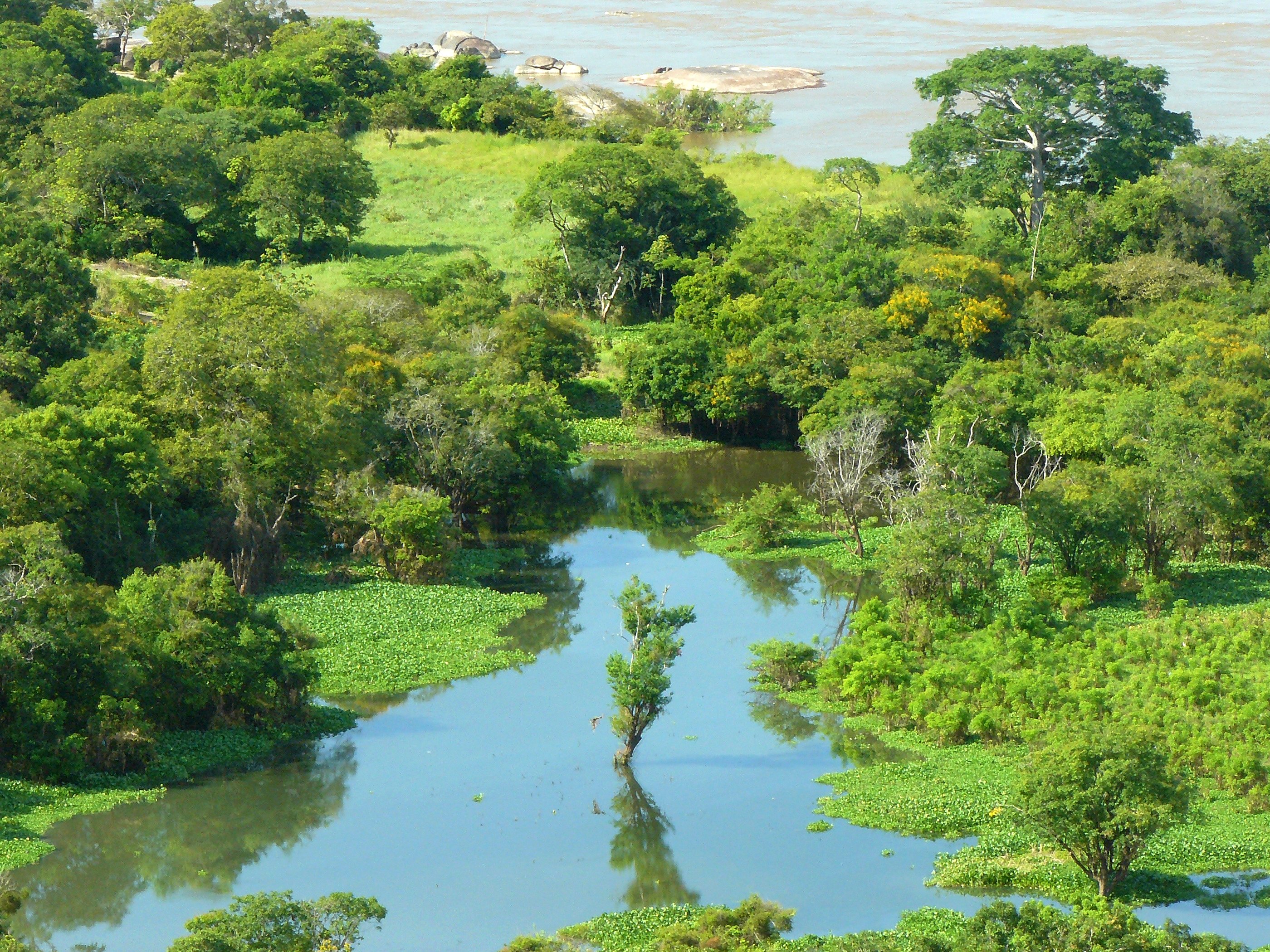
At its mouth, the Orinoco forms a wide delta that branches off into hundreds of rivers and waterways that flow through 41,000 km2 (16,000 sq mi) of swampy forests. In the rainy season, the Orinoco can swell to a breadth of 22 kilometres (14 mi) and a depth of 100 metres (330 ft).
Most of the important Venezuelan rivers are tributaries of the Orinoco, the largest being the Caroní, which joins it at Puerto Ordaz, close to the Llovizna Falls. A peculiarity of the Orinoco river system is the Casiquiare canal, which starts as an arm of the Orinoco, and finds its way to the Rio Negro, a tributary of the Amazon, thus forming a 'natural canal' between Orinoco and Amazon.
Major rivers in the Orinoco Basin
- Apure: from Venezuela through the east into the Orinoco
- Arauca: from Colombia to Venezuela east into the Orinoco
- Atabapo: from the Guiana Highlands of Venezuela north into the Orinoco
- Caroní: from the Guiana Highlands of Venezuela north into the Orinoco
- Casiquiare canal: in SE Venezuela, a distributary from the Orinoco flowing west to the Negro River, a major affluent to the Amazon
- Caura: from eastern Venezuela (Guiana Highlands) north into the Orinoco
- Guaviare: from Colombia east into the Orinoco
- Inírida: from Colombia southeast into the Guaviare.
- Meta: from Colombia, border with Venezuela east into the Orinoco
- Ventuari: from eastern Venezuela (the Guiana Highlands) southwest into the Orinoco
- Vichada: from Colombia east into the Orinoco
Ecology
The Boto, or Amazon River Dolphin, is also known to inhabit the Orinoco River system. The Orinoco Crocodile is one of the rarest reptiles in the world, with fewer than 250 specimens remaining in the wild. Its present-day range in the wild is restricted to the Orinoco River Basin. The Orinoco is home to the Caribe Piranha or Pygocentrus cariba.
Economic activity
The river is navigable for most of its length, and dredging enables ocean ships to go as far as Ciudad Bolívar, at the confluence of the Caroní River, 435 km (270 mi) upstream. River steamers carry cargo as far as Puerto Ayacucho and the Atures Rapids.
El Florero Iron Mine
In 1926 a Venezuelan mining inspector found one of the richest iron ore deposits near the Orinoco delta, south of the town of San Felix on a mountain name El Florero. Full-scale mining of the ore deposits began after World War II, by a conglomerate of Venezuelan firms and US steel companies. At the start in the early 1950s, about 10,000 tons of ore-bearing soil was mined per day.[4]
Orinoco Tar Sands
The Orinoco river deposits also contain extensive tar sands in the Orinoco oil belt, which may be a source of future oil production.[5]
Recreation and sports
Since 1988, the local government of Ciudad Guayana has conducted a swim race in the rivers Orinoco and Caroní, with up to 1000 competitors. Since 1991, the "Paso a Nado Internacional de los Rios Orinoco-Caroní" has been celebrated every year, on a Sunday close to 19 April. Worldwide, this swim-meet has gained in importance, and it has a large number of competitors.[6]
Notes
- ^ Orinoco River at GEOnet Names Server
- ^ Helferich, Gerard (2004) Humboldt's cosmos: Alexander von Humboldt and the Latin American journey that changed the way we see the world Gotham Books, New York, ISBN 1-59240-052-3.
- ^ "Ciudad Guayana, Venezuela : Image of the Day". earthobservatory.nasa.gov. http://earthobservatory.nasa.gov/IOTD/view.php?id=6215. Retrieved 2009-10-31.
- ^ "Venezuela's Magnetic Mountain" Popular Mechanics, July 1949
- ^ Forero, Juan (1 June 2006) "For Venezuela, A Treasure In Oil Sludge" New York Times Vol. 155 Issue 53597, pC1-C6
- ^ "Antecedentes y Sumario Paso a Nado Internacional de Los Rios Orinoco/Caroni" Paso Nado Internacional de Los Rios Orinoco y Caroní Official website in Spanish, translation of title: "Antecedents and Summary of the International Swim Meet of the Orinoco and Caroni Rivers"
References
- Stark, James H. 1897. Stark's Guide-Book and History of Trinidad including Tobago, Granada, and St. Vincent; also a trip up the Orinoco and a description of the great Venezuelan Pitch Lake. Boston, James H. Stark, publisher; London, Sampson Low, Marston & Company. (This book has an excellent description of a trip up the Orinoco as far as Ciudad Bolívar and a detailed description of the Venezuelan Pitch Lake situated on the western side of the Gulf of Paria opposite.)
- MacKee, E.D., Nordin, C.F. and D. Perez-Hernandez (1998). "The Waters and Sediments of the Rio Orinoco and its major Tributaries, Venezuela and Colombia." United States Geological Survey water-supply paper, ISSN 0083; 2326/A-B. Washington: United States Government Printing Office.
- Weibezahn, F.H., Haymara, A. and M.W. Lewis (1990). The Orinoco River as an ecosystem. Caracas: Universidad Simon Bolivar.
- Rawlins, C.B. (1999). The Orinoco River. New York: Franklin Watts.
External links
- "The Orinoco Heavy Oil Belt In Venezuela (or Heavy Oil to the Rescue?)" Department of Earth Science, Rice University
Tributaries of the Orinoco From the Guiana Highlands 
From elsewhere Inter-basin links Casiquiare canal (with Amazon)Categories:- Rivers of Colombia
- Rivers of Venezuela
- Colombia–Venezuela border
- International rivers of South America
- Orinoco basin


Wikimedia Foundation. 2010.