- Māhukona
-
Māhukona Hawaii, USA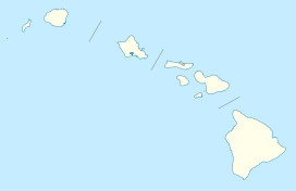
 Māhukona
Elevation −3,770 feet (−1,149 m) Location Range Hawaiian Islands Coordinates 20°01′N 156°01′W / 20.017°N 156.017°WCoordinates: 20°01′N 156°01′W / 20.017°N 156.017°W Topo map USGS Kamuela Geology Type Shield volcano, Hotspot volcano Volcanic arc/belt Hawaiian-Emperor seamount chain Last eruption About 470,000 BP Māhukona is a submerged shield volcano on the northwestern flank of the Island of Hawaiʻi. A drowned coral reef at about 3,770 feet (-1,150 m) below sea level and a major break in slope at about 4,400 feet (-1,340 m) below sea level represent old shorelines. The summit of the shield volcano was once 800 feet (250 m) above sea level. It has now subsided below sea level. A roughly circular caldera marks the summit of Māhukona. A prominent rift zone extends to the west. A second rift zone probably extended to the east but has been buried by younger volcanoes. The main shield-building stage of volcanism ended about 470,000 years ago. The summit of the shield volcano subsided below sea level between 435,000 and 365,000 years ago.[1] This makes Māhukona the oldest volcano to build Hawaiʻi island, compared to Kohala to the east and Hualālai to the southeast.[2]
An aftershock of the 2006 Hawaii earthquake of magnitude 6 hit about seven minutes after the main shock just to the south.[3] The Monterey Bay Aquarium Research Institute investigated the area with a remotely controlled submarine in 2001.[4]
It was named for the area known as Māhukona on the shore to the northeast.[5]
References
- ^ "Mahukona, Hawaii". Volcano World. Oregon State University. http://volcano.oregonstate.edu/vwdocs/volc_images/north_america/hawaii/mahukona.html. Retrieved June 23, 2010. attributed to:
David A. Clague; James G. Moore (April 1991). "Geology and Petrology of Mahukona Volcano". Hawaii: Bulletin of Volcanology 53 (3): 159–172. doi:10.1007/BF00301227. - ^ "Volcanoes of the Big Island". Volcano Watch. Hawaiian Volcano Observatory. September 15, 1995. http://hvo.wr.usgs.gov/volcanowatch/1995/95_09_15.html. Retrieved June 23, 2010.
- ^ "Progress in the year following the Kiholo Bay earthquake". Volcano Watch. Hawaiian Volcano Observatory. September 27, 2007. http://hvo.wr.usgs.gov/volcanowatch/2007/07_09_27.html. Retrieved June 23, 2010.
- ^ "Hawaii Cruise: March 13, 2001 to June 2, 2001". Monterey Bay Aquarium Research Institute. http://www.mbari.org/expeditions/Hawaii/history&purpose.htm. Retrieved June 23, 2010.
- ^ U.S. Geological Survey Geographic Names Information System: Māhukona
Further reading
- David A. Clague; Andrew T. Calvert (July 2009). "Postshield stage transitional volcanism on Mahukona Volcano, Hawaii". Hawaii: Bulletin of Volcanology 71 (5): 533–539. doi:10.1007/s00445-008-0240-z.
Hawaiian volcanism topics (List) Windward
Isles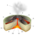
Leeward
IslesEmperor
SeamountsTopics Hawaiian – Emperor seamount chain · Evolution of Hawaiian volcanoes · Hawaiian eruption · ʻAʻā (lava) · Pāhoehoe (lava) · Pele's hair · Limu o Pele · Pele's tears · Lava fountain · Hawaiian Volcano Observatory · Hawaii Volcanoes National Park · Haleakala National Park · 1955 Hawaiian submarine eruptionCategories:- Shield volcanoes
- Hotspot volcanoes
- Extinct volcanoes
- Volcanoes of the Island of Hawaii
- Pleistocene volcanoes
- Hawaii geography stubs
- ^ "Mahukona, Hawaii". Volcano World. Oregon State University. http://volcano.oregonstate.edu/vwdocs/volc_images/north_america/hawaii/mahukona.html. Retrieved June 23, 2010. attributed to:


Wikimedia Foundation. 2010.