- Mount Tahan
-
Mount Tahan Gunung Tahan
ڬونوڠ تاهن
Gunung TahanElevation 2,187 m (7,175 ft) Location Taman Negara National Park, Pahang,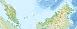
 Mount Tahan
 Malaysia
Range Tahan Range Coordinates 4°38′N 102°14′E / 4.633°N 102.233°ECoordinates: 4°38′N 102°14′E / 4.633°N 102.233°E Mount Tahan (Malay: Gunung Tahan), at 2,187 m, is the highest point in Peninsular Malaysia. It is located within the Taman Negara national forest, in the state of Pahang. The mountain is part of the Tahan Range and popular to local climbers.
In Malay language, "gunung" means "mountain" and "tahan" means "endure". Thus the name of the mountain suggests that a certain level of physical endurance is required to conquer the mountain. Gunung Tahan is considered by many to be one of the toughest treks in Peninsular Malaysia.
Contents
Trails
The Kuala Tahan classic trail is the oldest and most scenic trail. A return trip on this trail typically takes seven days. Climbers have to trek across undulating ridges and make several river crossings before finally reaching the foot of the mountain to make the final ascent.
Climbers without adequate physical fitness or training are not advised to attempt Gunung Tahan.
The other two trails are Merapoh (Sungai Relau) and via Kelantan. Both are significantly shorter than the classic trail from Kuala Tahan. A return trip on the Merapoh trail takes 3–4 days. A traverse from Kuala Tahan to Merapoh (or the other way around) takes around 5 days.
Gallery
-

River crossing near Kuala Juram
-

Sunset near Kem Botak
-

View at dawn near Kem Botak
-

Unnamed lesser peak, snapped from Kem Botak
-

Wooden signboard at the peak. The roof has been torn off due to severe weather in recent years.
-

Lembah Teku, snapped from somewhere above Kem Gedung
-

Kem Gedung
-

Steep descent via a series of metal ladders at Gunung Tangga Lima Belas
-

Rats will plunder your food at Kem Botak
-

Plenty of Usnea near the peak
-

Plenty of orchids, too, near the peak
-

Rafflesia spotted near Wray's Camp, on the way to down to Kuala Teku
See also
External links
Categories:- Mountains of Malaysia
-


Wikimedia Foundation. 2010.