- Manningtree
-
Coordinates: 51°56′39″N 1°03′41″E / 51.9443°N 1.0614°E
Manningtree 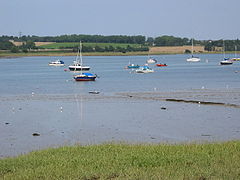
The River Stour at Manningtree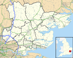
 Manningtree
Manningtree shown within EssexPopulation 900 (2001 census)[1] OS grid reference TM105317 District Tendring Shire county Essex Region East Country England Sovereign state United Kingdom Post town MANNINGTREE Postcode district CO11 Dialling code 01206 Police Essex Fire Essex Ambulance East of England EU Parliament East of England UK Parliament Harwich and North Essex List of places: UK • England • Essex Manningtree is a town and civil parish in the Tendring district of Essex, England, which lies on the River Stour. It adjoins built-up areas of Lawford to the west and Mistley to the east and the three parishes together are sometimes referred to as "Manningtree".
Manningtree is a claimant for the title of smallest town in England.
Contents
Smallest town
Manningtree has traditionally claimed to be the smallest town in England, and in 2007 mayor Lee Lay-Flurrie said that this had been confirmed to her by the Census Customer Services, with 700 people in 20 hectares[2] (using the high tide mark). However both this figure and the population of 900[1] in the civil parish is much higher than the 351 population of Fordwich in Kent.[3] In April 2009 it was proposed that Manningtree should merge with Mistley and Lawford to form a single parish, losing its separate identity as a town.[4]
History
 Manningtree Library
The name Manningtree is thought to derive from 'many trees'.[5] The town grew around the wool trade from the 15th century under its decline in the 18th century and also had a thriving shipping trade in corn, timber and coal until this declined with the coming of the railway.[5] Manningtree is known as the centre of the activities of Matthew Hopkins, the self-appointed Witchfinder General, who claimed to have overheard local women discussing their meetings with the devil in 1644 with his accusations leading to their execution as witches.[5]
Many of the buildings in the centre of the town have Georgian facades which obscure their earlier origins. Notable buildings include the town's library, which was originally built as, 'a public hall for the purposes of corn exchange' and was later used around 1900 for public entertainment,[5] and the oldest Methodist church in Essex, located on South Street.
The Ascension, by John Constable, which hangs in Dedham church, was painted for Manningtree church, pulled down in the 1960s.
Geography
Manningtree is on Holbrook Bay, part of the River Stour in the north of Essex. It is the eastern edge of Dedham Vale.
Nearby villages include Dedham, Mistley, Lawford, Wrabness and Brantham.
Manningtree railway station provides a direct train link to London, Norwich and Harwich.
Notable people
- Margaret Thatcher, lived in Manningtree, and worked for BX Plastics[6]
- Matthew Hopkins, the self-styled Witch-Finder General, lived in Manningtree
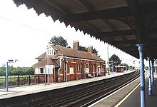 Manningtree Station
Twin town
See also
- Llanwrtyd Wells in Wales has a population of 601
References
- ^ a b "Area: Manningtree CP (Parish)". National Statistics. 28 April 2004. http://www.neighbourhood.statistics.gov.uk/dissemination/LeadTableView.do?a=7&b=794649&c=manningtree&d=16&e=15&g=446881&i=1001x1003x1004&m=0&r=1&s=1285290087953&enc=1&dsFamilyId=779. Retrieved 2010-09-24.[dead link]
- ^ "Essex: Town is happy to be small wonder". Echo Newspapers. 7 November 2007. http://archive.echo-news.co.uk/2007/11/7/262780.html. Retrieved 2010-09-24.[dead link]
- ^ "Area: Fordwich CP (Parish)". National Statistics. 28 April 2004. http://www.neighbourhood.statistics.gov.uk/dissemination/LeadTableView.do?a=7&b=795410&c=Fordwich&d=16&e=15&g=457433&i=1001x1003x1004&m=0&r=1&s=1285290383900&enc=1&dsFamilyId=779. Retrieved 2010-09-24.[dead link]
- ^ Collitt, Andrea (17 April 2009), "Manningtree: Threat to Mayor", Harwich and Manningtree Standard, http://www.harwichandmanningtreestandard.co.uk/news/localnews/4299842.Manningtree__Threat_to_Mayor/
- ^ a b c d Peers, Deborah (February 2009). "Once upon a time in... Manningtree". Essex Life (Archant Life): pp. 52.
- ^ Lewis, Russell (1975). Margaret Thatcher: a personal and political biography. Routledge and Kegan Paul. pp. 16. ISBN 0710082835. http://books.google.co.uk/books?id=Ypg9AAAAIAAJ&lpg=PA16&ots=7rjzlowCHh&dq=margaret%20thatcher%20manningtree&pg=PA16#v=onepage&q=&f=false.
External links
- Visit-Manningtree - Information and News/Events for the Manningtree area
- Manningtree Rail Users Association
- Manningtree High School
- Trinity Free Church - Manningtree
Categories:- Towns in Essex
- Tendring


Wikimedia Foundation. 2010.