Durham County, New South Wales

Durham County, New South Wales
Durham
New South Wales
Durham NSW.PNG
Location in New South Wales
Lands administrative divisions around Durham
Brisbane Hawes Gloucester
Brisbane Durham Gloucester
Hunter Northumberland Gloucester

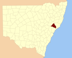
Durham County was one of the original Nineteen Counties in New South Wales and is now one of the 141 Cadastral divisions of New South Wales. It is bordered on the south and west by the Hunter River, and on the north and east by the Williams River. It includes Aberdeen and Muswellbrook. Before 1834, the area known as Durham County included what later became Gloucester and most of Brisbane counties, as far west as the Liverpool Range, and east to the Pacific, including Port Stephens, as shown on an 1832 map.

Durham County was named in honour of John George Lambton, First Earl of Durham (1792-1840).[1]

Parishes within this county

A full list of parishes found within this county; their current LGA and mapping coordinates to the approximate centre of each location is as follows:

Parish LGA Coordinates
Allyn Dungog Shire 32°07′54″S 151°28′04″E / 32.13167°S 151.46778°E / -32.13167; 151.46778 (Allyn Parish)
Althorpe Muswellbrook Shire 32°24′54″S 150°46′04″E / 32.415°S 150.76778°E / -32.415; 150.76778 (Althorpe Parish)
Auckland Singleton Shire 32°30′54″S 151°06′04″E / 32.515°S 151.10111°E / -32.515; 151.10111 (Auckland Parish)
Avenal Dungog Shire 32°18′54″S 151°34′04″E / 32.315°S 151.56778°E / -32.315; 151.56778 (Avenal Parish)
Balmoral Muswellbrook Shire 32°14′54″S 150°59′04″E / 32.24833°S 150.98444°E / -32.24833; 150.98444 (Balmoral Parish)
Barford Dungog Shire 32°32′54″S 151°38′04″E / 32.54833°S 151.63444°E / -32.54833; 151.63444 (Barford Parish)
Belltrees Upper Hunter Shire 31°58′54″S 151°10′04″E / 31.98167°S 151.16778°E / -31.98167; 151.16778 (Belltrees Parish)
Boonabilla Dungog Shire 32°07′54″S 151°22′04″E / 32.13167°S 151.36778°E / -32.13167; 151.36778 (Boonabilla Parish)
Bronte Upper Hunter Shire 31°53′54″S 151°24′04″E / 31.89833°S 151.40111°E / -31.89833; 151.40111 (Bronte Parish)
Brougham Muswellbrook Shire 32°18′54″S 150°53′04″E / 32.315°S 150.88444°E / -32.315; 150.88444 (Brougham Parish)
Butterwick Port Stephens Council 32°39′54″S 151°38′04″E / 32.665°S 151.63444°E / -32.665; 151.63444 (Butterwick Parish)
Carrow Dungog Shire 32°14′54″S 151°21′04″E / 32.24833°S 151.35111°E / -32.24833; 151.35111 (Carrow Parish)
Chalmers Upper Hunter Shire 32°02′54″S 151°13′04″E / 32.04833°S 151.21778°E / -32.04833; 151.21778 (Chalmers Parish)
Colonna Dungog Shire 32°14′54″S 151°31′04″E / 32.24833°S 151.51778°E / -32.24833; 151.51778 (Colonna Parish)
Darlington Singleton Shire 32°30′54″S 151°11′04″E / 32.515°S 151.18444°E / -32.515; 151.18444 (Darlington Parish)
Doon Upper Hunter Shire 32°05′54″S 151°15′04″E / 32.09833°S 151.25111°E / -32.09833; 151.25111 (Doon Parish)
Dungog Dungog Shire 32°25′54″S 151°43′04″E / 32.43167°S 151.71778°E / -32.43167; 151.71778 (Dungog Parish)
Dyrring Singleton Shire 32°25′54″S 151°17′04″E / 32.43167°S 151.28444°E / -32.43167; 151.28444 (Dyrring Parish)
Fingal Dungog Shire 32°27′54″S 151°36′04″E / 32.465°S 151.60111°E / -32.465; 151.60111 (Fingal Parish)
Foy Muswellbrook Shire 32°13′54″S 151°09′04″E / 32.23167°S 151.15111°E / -32.23167; 151.15111 (Foy Parish)
Glendon Dungog Shire 32°21′54″S 151°22′04″E / 32.365°S 151.36778°E / -32.365; 151.36778 (Glendon Parish)
Goorangoola Singleton Shire 32°23′54″S 151°08′04″E / 32.39833°S 151.13444°E / -32.39833; 151.13444 (Goorangoola Parish)
Gotha Singleton Shire 32°18′54″S 151°17′04″E / 32.315°S 151.28444°E / -32.315; 151.28444 (Gotha Parish)
Gresford Dungog Shire 32°29′54″S 151°32′04″E / 32.49833°S 151.53444°E / -32.49833; 151.53444 (Gresford Parish)
Herschell Muswellbrook Shire 32°13′54″S 151°05′04″E / 32.23167°S 151.08444°E / -32.23167; 151.08444 (Herschell Parish)
Holywell Dungog Shire 32°19′54″S 151°30′04″E / 32.33167°S 151.50111°E / -32.33167; 151.50111 (Holywell Parish)
Houghton Dungog Shire 32°36′0″S 151°33′57″E / 32.6°S 151.56583°E / -32.6; 151.56583 (Houghton Parish)
Howick Singleton Shire 32°27′54″S 150°56′04″E / 32.465°S 150.93444°E / -32.465; 150.93444 (Howick Parish)
Lewinsbrook Dungog Shire 32°22′54″S 151°33′04″E / 32.38167°S 151.55111°E / -32.38167; 151.55111 (Lewinsbrook Parish)
Liddell Muswellbrook Shire 32°21′54″S 151°00′04″E / 32.365°S 151.00111°E / -32.365; 151.00111 (Liddell Parish)
Liebeg Singleton Shire 32°14′54″S 151°15′04″E / 32.24833°S 151.25111°E / -32.24833; 151.25111 (Liebeg Parish)
Mamaran Upper Hunter Shire 31°47′54″S 151°24′04″E / 31.79833°S 151.40111°E / -31.79833; 151.40111 (Mamaran Parish)
Marwood Singleton Shire 32°33′54″S 151°21′04″E / 32.565°S 151.35111°E / -32.565; 151.35111 (Marwood Parish)
Middlehope Dungog Shire 32°39′54″S 151°38′04″E / 32.665°S 151.63444°E / -32.665; 151.63444 (Middlehope Parish)
Mirannie Singleton Shire 32°27′54″S 151°20′04″E / 32.465°S 151.33444°E / -32.465; 151.33444 (Mirannie Parish)
Moonan Upper Hunter Shire 31°56′54″S 151°14′04″E / 31.94833°S 151.23444°E / -31.94833; 151.23444 (Moonan Parish)
Mount Royal Singleton Shire 32°10′54″S 151°18′04″E / 32.18167°S 151.30111°E / -32.18167; 151.30111 (Mount Royal Parish)
Oldcastle Upper Hunter Shire 32°00′54″S 151°19′04″E / 32.015°S 151.31778°E / -32.015; 151.31778 (Oldcastle Parish)
Omadale Upper Hunter Shire 31°51′54″S 151°20′04″E / 31.865°S 151.33444°E / -31.865; 151.33444 (Omadale Parish)
Prospero Upper Hunter Shire 31°59′54″S 151°22′04″E / 31.99833°S 151.36778°E / -31.99833; 151.36778 (Prospero Parish)
Ravensworth Singleton Shire 32°29′54″S 151°00′04″E / 32.49833°S 151.00111°E / -32.49833; 151.00111 (Ravensworth Parish)
Rosamond Singleton Shire 32°09′54″S 151°15′04″E / 32.165°S 151.25111°E / -32.165; 151.25111 (Rosamond Parish)
Rouchel Upper Hunter Shire 32°07′54″S 151°00′04″E / 32.13167°S 151.00111°E / -32.13167; 151.00111 (Rouchel Parish)
Rowan Muswellbrook Shire 32°13′54″S 150°57′04″E / 32.23167°S 150.95111°E / -32.23167; 150.95111 (Rowan Parish)
Russell Upper Hunter Shire 32°09′54″S 150°57′04″E / 32.165°S 150.95111°E / -32.165; 150.95111 (Russell Parish)
Savoy Muswellbrook Shire 32°20′54″S 150°57′04″E / 32.34833°S 150.95111°E / -32.34833; 150.95111 (Savoy Parish)
Seaham Port Stephens Council 32°39′25″S 151°41′57″E / 32.65694°S 151.69917°E / -32.65694; 151.69917 (Seaham Parish)
Sedgefield Singleton Shire 32°31′54″S 151°15′04″E / 32.53167°S 151.25111°E / -32.53167; 151.25111 (Sedgefield Parish)
Shenstone Singleton Shire 32°23′54″S 151°12′04″E / 32.39833°S 151.20111°E / -32.39833; 151.20111 (Shenstone Parish)
St Aubins Upper Hunter Shire 32°10′54″S 151°00′04″E / 32.18167°S 151.00111°E / -32.18167; 151.00111 (St Aubins Parish)
St Julian Dungog Shire 32°22′54″S 151°28′04″E / 32.38167°S 151.46778°E / -32.38167; 151.46778 (St Julian Parish)
Stanhope Singleton Shire 32°33′54″S 151°25′04″E / 32.565°S 151.41778°E / -32.565; 151.41778 (Stanhope Parish)
Tangory Singleton Shire 32°28′54″S 151°24′04″E / 32.48167°S 151.40111°E / -32.48167; 151.40111 (Tangory Parish)
Tillegra Dungog Shire 32°20′54″S 151°42′04″E / 32.34833°S 151.70111°E / -32.34833; 151.70111 (Tillegra Parish)
Tudor Upper Hunter Shire 32°10′54″S 151°08′04″E / 32.18167°S 151.13444°E / -32.18167; 151.13444 (Tudor Parish)
Tyraman Dungog Shire 32°29′54″S 151°30′04″E / 32.49833°S 151.50111°E / -32.49833; 151.50111 (Tyraman Parish)
Uffington Dungog Shire, Port Stephens Council 32°35′54″S 151°44′04″E / 32.59833°S 151.73444°E / -32.59833; 151.73444 (Uffington Parish)
Underbank Dungog Shire 32°14′54″S 151°33′04″E / 32.24833°S 151.55111°E / -32.24833; 151.55111 (Underbank Parish)
Vane Singleton Shire 32°26′54″S 151°07′04″E / 32.44833°S 151.11778°E / -32.44833; 151.11778 (Vane Parish)
Vaux Muswellbrook Shire 32°20′54″S 150°47′04″E / 32.34833°S 150.78444°E / -32.34833; 150.78444 (Vaux Parish)
Wallarobba Dungog Shire 32°28′54″S 151°43′04″E / 32.48167°S 151.71778°E / -32.48167; 151.71778 (Wallarobba Parish)
Wolfingham Dungog Shire 32°37′54″S 151°29′04″E / 32.63167°S 151.48444°E / -32.63167; 151.48444 (Wolfingham Parish)
Wynn Muswellbrook Shire 32°21′54″S 150°52′04″E / 32.365°S 150.86778°E / -32.365; 150.86778 (Wynn Parish)

References

  1. ^ Geographical Names Board of NSW

External links


Wikimedia Foundation. 2010.

Игры ⚽ Поможем решить контрольную работу

Look at other dictionaries:

  • Gloucester County, New South Wales — Infobox Australian cadastral name = Gloucester state = New South Wales caption = Location in New South Wales near nw = Hawes near n = Macquarie near ne = Pacific Ocean near e = Pacific Ocean near se = Pacific Ocean near s = Northumberland near sw …   Wikipedia

  • Brisbane County, New South Wales — Infobox Australian cadastral name = Brisbane state = New South Wales caption = Location in New South Wales near nw = Pottinger near n = Buckland near ne = Parry near e = Hawes near se = Durham near s = Hunter near sw = Phillip near w =… …   Wikipedia

  • Hunter County, New South Wales — Infobox Australian cadastral name = Hunter state = New South Wales caption = Location in New South Wales near nw = Phillip near n = Brisbane near ne = Durham near w = Phillip near e = Northumberland near sw = Roxburgh near s = Cook near se =… …   Wikipedia

  • Hawes County, New South Wales — Infobox Australian cadastral name = Hawes state = New South Wales caption = Location in New South Wales near nw = Parry near n = Vernon near ne = Dudley near e = Macquarie near se = Gloucester near s = Gloucester near sw = Durham near w =… …   Wikipedia

  • Northumberland County, New South Wales — Map of all coordinates from Google Map of all coordinates from Bing Export all coordinates as KML …   Wikipedia

  • New South Wales Legislative Assembly electoral districts — The New South Wales Legislative Assembly is elected from 93 single member electorates called districts. Current districts This is a list of districts for the 2007 general election.* Albury * Auburn * Ballina * Balmain (1880 1894: Balmain; 1894… …   Wikipedia

  • Durham County — may refer to: Durham County, North Carolina Durham County, Ontario Durham County, New South Wales Durham County, Western Australia Durham County (TV series) See also County Durham, a ceremonial county in North East England Durham Regional… …   Wikipedia

  • Clarence Town, New South Wales — Clarence Town New South Wales …   Wikipedia

  • Duns Creek, New South Wales — Duns Creek New South Wales Population: 300[1]Note1 …   Wikipedia

  • Nelsons Plains, New South Wales — Nelsons Plains New South Wales Flooding at Nelsons Plains in 2007 Postco …   Wikipedia

Share the article and excerpts

Direct link
Do a right-click on the link above
and select “Copy Link”