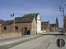
- Mazinghien
-
Mazinghien


 MazinghienLocation within Nord-Pas-de-Calais region
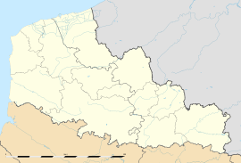 Mazinghien
Administration Country France Region Nord-Pas-de-Calais Department Nord Arrondissement Cambrai Canton Le Cateau-Cambrésis Intercommunality Caudrésis - Catésis Mayor Michel Hennequart
(2008–2014)Statistics Elevation 143–161 m (469–528 ft) Land area1 9.01 km2 (3.48 sq mi) Population2 302 (1999) - Density 34 /km2 (88 /sq mi) INSEE/Postal code 59395/ 59360 1 French Land Register data, which excludes lakes, ponds, glaciers > 1 km² (0.386 sq mi or 247 acres) and river estuaries. 2 Population without double counting: residents of multiple communes (e.g., students and military personnel) only counted once. Coordinates: 50°03′01″N 3°36′16″E / 50.0502777778°N 3.60444444444°E
Mazinghien is a commune in the Nord department in northern France.
 Map of Mazinghien
Heraldry
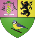
The arms of Mazinghien are blazoned :
Vert, a titmouse proper perched on a branch, on a chief per pale 1: purpure, ??? and 2: Or, a lion sable, armed and langued gules.
Note1: as drawn, this is a 'per fess' rather than field and chief.
Note2: the bird shown is a Great Tit (Parus major)See also
References
Categories:- Communes of Nord
- Nord geography stubs


Wikimedia Foundation. 2010.