- Catbalogan City
Infobox Settlement
official_name = City of Catbalogan
settlement_type =
motto =
imagesize =
imagesize =
image_caption =
flag_size =
image_
seal_size = 120px
image_shield =
shield_size =
city_
citylogo_size =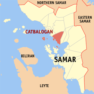
mapsize =
map_caption = Map ofSamar showing the location of Catbalogan City Coordinates: 11°47' N 124°53' E
mapsize1 =
map_caption1 =
pushpin_
pushpin_label_position =
pushpin_map_caption =
pushpin_mapsize =
subdivision_type = Country
subdivision_name =Philippines
subdivision_type1 = Region
subdivision_name1 =Eastern Visayas (Region VIII)
subdivision_type2 = Province
subdivision_name2 =Samar (Capital)
subdivision_type3 = District
subdivision_name3 = 2nd District of Samar
subdivision_type4 =Barangays
subdivision_name4 = 57
government_type =
leader_title = City Mayor
leader_name =Hon. Coefredo T. Uy
leader_title1 =
leader_name1 =
established_title =
established_date =
established_title2 = Incorporated (town)
established_date2 = 1596
established_title3 = Incorporated (city)
established_date3 =March 15 ,2007
area_magnitude =
unit_pref =
area_footnotes =
area_total_km2 = 274.22
area_land_km2 =
area_water_km2 =
area_total_sq_mi =
area_land_sq_mi =
area_water_sq_mi =
area_water_percent =
area_urban_km2 =
area_urban_sq_mi =
area_metro_km2 =
area_metro_sq_mi =
population_as_of = 2007
population_footnotes =
population_note =
population_total = 92,454
population_density_km2 = 337.2
population_density_sq_mi =
population_metro =
population_density_metro_km2 =
population_density_metro_sq_mi =
population_urban =
population_density_urban_km2 =
population_density_urban_sq_mi =
timezone = PST
utc_offset = +8
timezone_DST =
utc_offset_DST =
latd= |latm= |lats= |latNS=
longd= |longm= |longs= |longEW=
elevation_footnotes =
elevation_m =
elevation_ft =
postal_code_type =
postal_code =
area_code = 55
blank_name =
blank_info =
blank1_name =
blank1_info =
website = http://www.catbalogan.gov.ph
footnotes =Catbalogan City is the capital city of
Samar Province ,Philippines with a population of 92,454 people (2007 Census). It is Samar's main commercial, trading, educational, political and financial center. It is also an important and majorseaport serving inter-island vessels. Catbalogan City's central geographical location inEastern Visayas makes it ideal as the gateway to the three Samar provinces.History
The city of Catbalogan was founded or settled sometime in October 1596, by the
priest s of theJesuit Order (Society of Jesus.)Friar Francisco de Otazo , S.J., who arrived in the Philippines in 1596, founded the Catbaloganmission and was thus the first missionary to bring the Catholic faith to the people of Catbalogan. In 1627, Catbalogan was raised to the status of "residencia" (residence or central house.) On October 17, 1768, Catbalogan was ceded to theFranciscan s who took over from theJesuit s. The first Franciscan parish priest wasFray Jose Fayo , OFM.The original name of the city was KATBALAUGAN or KABALAUGAN. The two syllables of the name are compounds of the prefix KAT or KA and the substantive noun BALAUG of the Samar-Leyte Visayan language (Waray).Fact|date=September 2008 “Katbalaugan or Kabalaugan” means “a place where seafarers, fishermen or sailors take shelter or protection.” The old fishing village of Katbalaugan or Kabalaugan was the refuge of people riding in small boats and sailboats when the northwest and southwest monsoons blew during the months of July, August, and September.
During the early days of Spanish colonization of the Philippines, Samar was under the jurisdiction of
Cebu . Later, it was declared a separate province. In 1735,Samar andLeyte were united into one province withCarigara , in Leyte, as the capital. The union, however, did not prove satisfactory. In 1768, Samar again became a separate province from Leyte. Since then, Samar has emerged as an independent province with Catbalogan City as the capital.On January 27, 1900, the Americans captured the city of Catbalogan in the
Philippine-American War . Civil government was established on June 17, 1902 withJulio Llorente of Cebu as the first governor of Samar.On May 24, 1942, during
World War II ,Japanese forces landed inBarrio Pangdan and occupied the capital. On December 18, 1945, the American and Filipino forces liberated the city from the Japanese.On June 19, 1965, the
Philippine Congress approvedRepublic Act No. 4221 dividing Samar intoWestern Samar ,Eastern Samar andNorthern Samar , respectively. Catbalogan thus ceased to be the capital of the whole island-province after enjoying the prestige of being the premier town of Samar for 197 years since 1768. On June 21, 1969, underRepublic Act No. 5650 , Western Samar was renamed Samar with Catbalogan still as the capital city.The greatest calamities to occur in Catbalogan City were big fires. The April 1, 1957 conflagration, considered as the most destructive one, caused damage to properties in the amount of thirty million pesos. The next was on May 19, 1969, where damage was estimated at twenty million pesos and the more than century-old
Saint Bartholomew Roman Catholic Church was razed to the ground. Paradoxically, like the proverbialPhoenix , each time Catbalogan City suffered under the throes of these calamities, better buildings and infrastructures emerged from the ashes.As early as 1960, Catbalogan already agitated to become a city. In 1969, Rep.
Fernando P. Veloso sponsoredHouse Bill No. 1867 creating Catbalogan into a component city. The bill was being deliberated in thePhilippine Senate , but the conflagration of 1969 unfortunately caused it to be shelved. Subsequent efforts were made by Catbalogan's and Samar's political leaders such as MayorsJesus B. Redaja andCoefredo T. Uy , Vice MayorsGerardo C. Teves andManuel Van A. Torrevillas , CouncilorArt Sherwin L. Gabon and RepresentativesAntonio Eduardo B. Nachura andCatalino V. Figueroa , respectively, to make Catbalogan's cityhood dream a reality despite strong opposition by the League of Cities of the Philippines.On March 15, 2007, Catbalogan finally attained its cityhood. Under the sponsorship of Senator
Alfredo S. Lim and by virtue ofRepublic Act No. 9391 , Catbalogan was converted into a component city known as the CITY OF CATBALOGAN following a unanimous vote by the Philippine Senate. SenatorManuel Villar, Jr. (President of the Senate),Jose De Venecia, Jr. (Speaker of the House of Representatives),Oscar G. Yabes (Secretary of the Senate),Roberto P. Nazareno (Secretary General, House of Representatives) andGloria Macapagal-Arroyo (President of the Philippines) were among its signatories. The residents of Catbalogan overwhelmingly ratified this change through aComelec plebiscite onJune 16 ,2007 .Geography
Location
The capital city of Catbalogan is strategically located in the western seacoast of the
Province of Samar ,Eastern Visayas region. It is bounded to the north by the municipalities ofTarangnan andSan Jorge , to the east by the municipality ofJiabong , and to the west by theMaqueda Bay with its beautiful sunsets. ThePan-Philippine Highway (Maharlika Highway) traverses the city fromBarangay San Vicente in the north through the poblacion toBarangay Lagundi in the south. Catbalogan City is about 802 kilometers south ofManila , the capital of the Philippines.Land Area
The total land area of Catbalogan City is 274.22 km². Its city proper covers an area of 1.30 km².
There are 57
barangay s in the entire city, twenty-one of which are situated in thepoblacion . Another twenty-one barangays are located in the coastal areas and fifteen are in the interior or upland areas.Topography
The
topography of Catbalogan City is rough and its mountains are relatively high. Approximately 2% of the land area are plain and mostly found along theseacoast while 43% are rollinghill s and 55% aremountain ous.The coastline of Catbalogan City is irregular with
bay s bordering thepoblacion and otherbarangays . Its coastline has a total length of about ten miles.Climate
The
climate is classified as 4th type (Mild) where rainfall is evenly distributed throughout the year.In Catbalogan City there is hardly a month without rainfall. Generally, there is no distinct dry season but the months of February, March, April and May comprise the short dry season. Rainfall is uniform throughout the year and heaviest during the months of November and December.
Typhoon s occur during the latter months of the year. Although Samar has been known as a typhoon-prone area, the truth is, the island of Samar is used only as a reference point by thePhilippine Atmospheric, Geophysical and Astronomical Services Administration (PAGASA.)Soil Types
The soils of Catbalogan City are of two types, namely, the
Catbalogan clay loam andfaraon clay . The clay loam, the predominant one, is developed fromshale s andsandstone s. It is particularly suited foragriculture especiallyrootcrop s. The faraon clay, on the other hand, is a residual fromcorraline limestone and is fair withorganic matter contents. Limestone rocks are sometimes found on the surface.Barangays (Villages)
Catbalogan City is politically subdivided into 57
barangay s.
* Albalate
* Bagongon
* Bangon
* Basiao
* Buluan
* Bunuanan
* Cabugawan
* Cagudalo
* Cagusipan
* Cagutian
* Cagutsan
* Canhawan Guti
* Canlapwas (Pob.)
* Cawayan
* Cinco
* Darahuway Daco
* Darahuway Guti
* Estaka
* Guinsorongan
* Iguid
* Lagundi
* Libas
* Lobo
* Manguehay
* Maulong
* Mercedes
* Mombon
* New Mahayag
* Old Mahayag
* Palanyogon
* Pangdan
* Payao
* Poblacion 1 (Barangay 1)
* Poblacion 2 (Barangay 2)
* Poblacion 3 (Barangay 3)
* Poblacion 4 (Barangay 4)
* Poblacion 5 (Barangay 5)
* Poblacion 6 (Barangay 6)
* Poblacion 7 (Barangay 7)
* Poblacion 8 (Barangay 8)
* Poblacion 9 (Barangay 9)
* Poblacion 10 (Barangay 10-Monsanto Street)
* Poblacion 11 (Barangay 11)
* Poblacion 12 (Barangay 12)
* Poblacion 13 (Barangay 13)
* Muñoz (Poblacion 14)
* Pupua
* Guindaponan
* Rama
* San Andres
* San Pablo
* San Roque
* San Vicente
* Silanga
* Totoringon
* Ibol
* SocorroTransportation
Catbalogan City can be reached from
Manila orTacloban City by land, air or sea.AIR
* Currently, no commercial flights to Catbalogan City are available. However, the Catbalogan City airportCatbalogan Airport onBuri Island is accessible to private and charter jets from Manila, Cebu and other destinations.SEA
* ThePort of Catbalogan (Piers I and II) is classified as a national port. It is a major seaport that can handle passengers and cargoes to and from Manila, Cebu and other places.LAND
* Bus transit is the dominant public land transport to Catbalogan City from Manila or Tacloban City passing through thePan-Philippine Highway (Maharlika Highway). The public mode of transportation within the city is bytricycle s orpedicab s.Notable Attractions / Landmarks
*The Obelisk - located in the heart of Catbalogan City's Samar Provincial Capitol Park, it depicts four major events in Samar's history - the 1901
Balangiga Encounter that saw local revolutionaries inflicting the "worst single defeat" of the Americans during thePhilippine-American War ; the 1649Sumoroy Rebellion inPalapag against theSpaniard s; the 1596 arrival of the firstJesuit missionaries to Samar; andQueen Isabella II of Spain carrying aRoyal Decree of August 11, 1841 declaring Samar a province."'*
Buri Baras Cove Beach Resort - located onBuri Island , it is 12 km from the city proper. The beach has a long coastal stretch and is ideal for swimming and diving.*
Bangon Falls - located inBarangay Bangon in the interior mountains of Catbalogan City.*
Basiao Island Beach *
Cal-apog Leopard Beach Resort - a rocky beach located inBarangay Pangdan .*"Campo" Historical Landmark
*
Igot Cove *
Mendoza Beach Resort *
Malatugawi Island Beach *
Payao Beach *
Pieta Park - located adjacent toSt. Bartholomew Church , it has a memorial honoring Catbaloganons and four thousand others who perished in the December 1987 tragic collision of the passenger shipMV Doña Paz and the oil tankerMT Vector . The Doña Paz tragedy is described by historians as the worst ferry disaster and the world's worst peace-time maritime disaster in history.*
Saint Bartholomew Roman Catholic Church *
Samar Provincial Capitol *
Sunshine Beach - a prominent beach located inBarangay Guinsorongan within the city proper.*
Waray Banwa Coral Reef - located just 2 km offGuinsorongan (Sunshine) Beach.Elementary Schools
*Catbalogan I Central Elementary School
*Catbalogan II Central Elementary School
*Catbalogan III Central Elementary School
*Catbalogan IV Central Elementary School
*Catbalogan V Central Elementary School
*Elementary School Departments (Saint Mary's College of Catbalogan, Samar College)
*Chinese Chamber Schoolecondary Schools
*Samar National School (formerly Samar High School)
*High School Departments (Saint Mary's College of Catbalogan, Samar College, Samar State University)
*Catbalogan National Comprehensive High School
*Eastern Visayas Regional Science High School
*Antonio G. Tuazon Memorial National High School
*Guinsorongan Integrated School
*Silanga National High SchoolColleges/Universities
* [http://www.rvmonline.net/smccatbalogan/ St. Mary's College of Catbalogan (formerly Sacred Heart College)]
*Samar College
*Samar State UniversityHospital / Health Facilities
*Samar Provincial Hospital
*Catbalogan City Puericulture Center and Maternity HospitalBanks / Financial Institutions
*Allied Banking Corporation
*China Bank Corporation
*Development Bank of the Philippines
*Land Bank of the Philippines
*Metropolitan Bank & Trust Company
*PCI - Equitable Bank
*Philippine National Bank
*Rizal Commercial Banking Corporation
*Banco De OroHotels / Lodging
* [http://www.samarnews.com/business/rolet/ Rolet Hotel]
* [http://cellcomhotel.e-ph.net/ Cell.Com Hotel]
*Maqueda Bay Hotel
*Fame Hotel
*Fortune Hotel and Restaurant
*Bay View Inn
*Summer's Garden Pensionne
*Rose Scent Pensionne
*Villarin's Bed & Breakfast
*Casa Cristina Hotel
*Sto. Rosario Pensionne
*Traveler's Lodging House
*Kalinayan Inn
*Eduardo's Inn
*Samar State University (SSU) HostelMall
*Centro Mall
Restaurants / Eateries
*Charito's Delights
*Eduardo's RestoBar
*Ernie's Pizza
*Fortune Hotel and Restaurant
*JC Foodspot
*Jollibee
*Taby's Place
*Tina's Garden Restaurant
*Tony's Kitchen & RestaurantTV Networks and Cable Television / Media
*
ABS-CBN Catbalogan City
*Decobeam Cable TV Services
*D'Leopards CATV* [http://www.samarnews.com Samar News.com] - based in Catbalogan City, it is a source of news and information on Eastern Visayas.
*Samar Tambayan.net - a portal and community website for Samar, especially Catbalogan City.Radio Stations
*
DYMS
*DYRV Telecommunications
*Bayan Telecommunications, Inc. (Bayan Tel)
*Bureau of Telecommunications
*Globe Telecom
*Smart Communications, Inc. (Smart Wireless)
*Sun Cellular NetworkFestivals
*The Manaragat Festival - Held during Catbalogan City's Charter Day Celebration (1st-2nd Weeks of June), it is one of the most colorful and vivid rituals in Catbalogan City and is a tribute to the fishermen with festive dance and original music.
*Kaadlawan Han Samar (Samar Day) - August 11 - Festivities held in Catbalogan City, it marks the celebration of Samar's Foundation Day. The festival is participated by the province's two cities and twenty-four municipalities and includes cultural dance competitions, agro-fisheries trade fair and civic-military parade.
Government
Elected city officials in the election on May 14, 2007:
City Mayor: Hon. Coefredo T. Uy
City Vice Mayor: Hon. Manuel Van A. Torevillas
City Councilors:
* Hon. Arthur Vaughn Zosa* Hon. Rodrigo C. Perez, Jr.
* Hon. Manuel F. Correche
* Hon. Perfecta Sabenecio
* Hon. Herminia S. Cabral
* Hon. Rodolfo T. Aquino
* Hon. Teodoro V. Ilagan
* Hon. Art Sherwin L. Gabon
* Hon. Calixtro H. Rosales
* Hon. Michelle Rose Arseño
External links
*http://www.catbalogan.gov.ph/ Official Website of the City of Catbalogan
* [http://www.nscb.gov.ph/activestats/psgc/default.asp Philippine Standard Geographic Code]
Wikimedia Foundation. 2010.