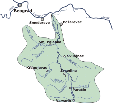
- Great Morava
-
Not to be confused with Great Moravia.
Velika Morava (Велика Морава) 
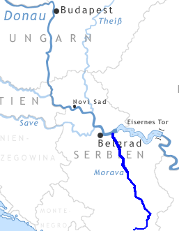
Drainage basin of Great Morava (without South and West Morava)Origin Stalać, central Serbia, from Zapadna Morava and Južna Morava Mouth Danube, east of Smederevo, Serbia Basin countries Serbia, Montenegro, Macedonia, Bulgaria Length 185 km (493 km) Avg. discharge 255 m³/s at the mouth Basin area 37,444 km² The Great Morava (Serbian: Велика Морава, Velika Morava, pronounced [v̞ê̞likaː mɔ̌rav̞a]) is the final section of the Morava (Cyrillic: Морава), a major river system in Serbia.
Contents
Length
The Velika (Great) Morava is created by the confluence of the South Morava and the West Morava, located near the small town of Stalać, a major railway junction in central Serbia. From there to its confluence with the Danube northeast of the city of Smederevo, the Velika Morava is 185 km long. With its longer branch, the West Morava, it is 493 km long. The South Morava, which represent the natural headwaters of the Morava, used to be longer than the West Morava, but due to the regulations of river bed and melioration, today it is shorter. Regulations were made on all three branches, and they all used to be much longer, so the Morava was over 600 km long. Today, the most distant water source in the Morava watershed is the source of the river Ibar, right and longest tributary of the Zapadna Morava, originating in Montenegro, which gives the Ibar-West Morava-Great Morava river system a length of 550 km, which still makes it the longest waterway in the Balkan Peninsula.
Geography
 Velika Morava and Južna Morava
The area of drainage basin of Velika Morava is 6,126 km², and of whole Morava system 37,444 km² (of that, 1,237 km² in Bulgaria and 44 km² in Macedonia), which covers 42,38% of Serbia. Velika Morava flows through the most fertile and densely populated area of Central Serbia, called Morava river valley, or Pomoravlje. Pomoravlje actually was formed in a fossil bay of a vast, ancient Pannonian Sea which dried out 200,000 years ago. On about half of its length it passes through beautiful Bagrdan gorge (Bagrdanska klisura). In past centuries, it was known for its seemingly endless forests, but there is almost nothing left today of those big old woods. It flows into the Danube between villages of Kulič & Dubravica, in a big coal mining basin of Kostolac, one of two major in its drainage basin, other one being Resava coal basin, in valley of the Velika Morava's right tributary Resava. Average discharge of Velika Morava on its confluence with Danube is 255 m³/s (120 m³/s brought by Zapadna Morava, 100 m³/s by Južna Morava, and 35 m³/s amounted by Velika Morava itself).
Tributaries
Tributaries of the Velika Morava are short in length, longest one being the Jasenica (79 km) and others rarely exceeding 50 km. Right tributaries are: Jovanovačka reka, Crnica, Ravanica, Resava and Resavica (or Resavčina). Left tributaries are more numerous, including: Kalenićka reka, Lugomir, Belica River, Lepenica, Rača, and Jasenica. Many of them don't carry much water, but in rainy years, they are known for causing major floods, which is the big problem of the whole Morava river system. Before it meets Danube, Velika Morava splits, creating 47 km long arm called Jezava, which flows into the Danube separately, in the town of Smederevo, and it's joined by longer (51 km) river Ralja, from the left.
Improvements
The Velika Morava represents a text book example of a meandering river. It used to be 245 km long, but from its origin, to the Danube, there is only 118 km in distance, so its meandering ratio is 118:245, one of the highest in Europe.
The river bed is 80–200 m wide, and the depth as much as 10 m. Notorious for its flooding, the Morava has changed its course many times, and old river bends have become small lakes, known as moravište. Južna Morava, with extremely high erosion in its drainage basin, brings huge amounts of materials which are elevating Velika Morava's river bed, making floods even more frequent.
Beginning in 1966, huge works began on all three rivers to prevent future floodings. Series of reservoirs were made on tributaries (lakes Bovan, Ćelije, Gazivode, etc.), and meanders were cut through, making river courses straightened, which made them shorter (in case of Velika Morava, from 245 to 185 km). It was projected that it will shorten by as much as 152 km, and that it will become navigable again.
Altogether, 18 reservoirs are projected, 23 meanders are to be cut, a series of embankments built and intensive afforestation started. However, since the late 1980s and especially since the 1990s, with economic crises and wars in former Yugoslavia, this all stopped.
The Morava and its tributaries still flood often, so its bed still is elevated, despite dozens of gravel-digging companies in cities and villages near the river's upper course (Lozovik, Lugavčina, Lučica, Velika Plana, etc.).
 View from Lapovo
Today, Velika Morava is navigable for only 3 km from its mouth. In the past it was navigable all the way to the city of Ćuprija, for about 3/4 of its length. But, as mentioned before, Velika Morava literally gets buried under the materials brought by Južna Morava. When melioration program began in 1966, it was projected it would become navigable again, in the first phase to Ćuprija, and in the next all the way to Stalać, making it 100% navigable. Even at that time this didn't seem very likely and was probably nothing but a wishful thinking of some local politician, which was common during the Communist period. None of it has been accomplished. From time to time, the idea of digging Danube-Morava-Vardar-Aegean Sea * [1] navigable canal pops up in the media. Technical problems of making this waterway would be enormous (neither Morava or Vardar are navigable), it is not sure how much it would be used, and presumably it would cost (4.4 billion dolars) way too much, so it remains mostly as a sort of popular curiosity.
Settlements
Even though Morava valley has always been the most populous part of Serbia, disastrous floodings prevented people from settling on the river banks itself. The only urban settlement on the river banks is Ćuprija, but it often suffers from floods (including several times in the 1990s). Others urban settlements, built a little further away from the river itself, include: Paraćin, Jagodina, Batočina, Lapovo, Svilajnac, Velika Plana, Požarevac and Smederevo. Smaller places and villages include: Varvarin, Glogovac, Markovac, Veliko Orašje, Miloševac and Lozovik.
Tradition
The Romans called it Margus (in addition to that, Zapadna Morava was named Brongus, and Južna Morava was Angrus). Present city of Ćuprija existed in Roman times as Horreum Margi (meaning The Granary of Morava). In Serbian history, its valley became the cradle of the modern Serbian state in the beginning of the 19th century (so called Moravian Serbia; Moravska Srbija). Many songs are written in celebration of Morava and its fertility, but most of them sing also about causalties and damages done by the river during floods. Songs are even made today about it, and the most famous are: Oj Moravo (Oh, Morava), Moravo, tija reko (Morava, you quiet river), Uz Moravu vetar duva (Wind blows up the Morava), Na Moravi vodenica stara (Old mill on Morava), Moravac kolo (Morava kolo), etc. Oj Moravo may be the most characteristic:
- 'Oj Moravo, moje selo ravno,
- Kad si ravno što si vodoplavno
- Kiša pade, te Morava dođe,
- Te poplavi moje selo ravno
- A u selu Jovanove dvore,
- I u dvoru Jovanovu ljubu'
- Oh, Morava, my plain village,
- If it's so plain, why do you flood it
- Rains came, so Morava rose,
- And flooded my plain village
- And in the village it flooded Jovan's home,
- And in it, his loving wife'
References
- Mala Prosvetina Enciklopedija, Third edition (1985); Prosveta; ISBN 86-07-00001-2
- Jovan Đ. Marković (1990): Enciklopedijski geografski leksikon Jugoslavije; Svjetlost-Sarajevo; ISBN 86-01-02651-6
- PIM "Ivan Milutinović", Belgrade, Serbia ; Morava - Vardar (Axios) Navigation Route (About 1,200 km shorter route (three days shorter time of navigation) from Belgrade to Port of Thessaloniki than across Danube, Black Sea and Agean Sea. Electric power production, improvement of water quality and regulation of flooding wave.)
- Morava - Vardar (Axios) Navigation Route map
- Hydropower and navigation syustem "Morava" (Concepts of regulation of rivers Great Morava and South Morava for navigation and hydropower production.)
See also
The Danube Countries 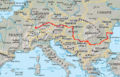
Cities Tributaries Islands Coordinates: 44°42′42″N 21°02′05″E / 44.71167°N 21.03472°E
Categories:- Rivers of Serbia
- Šumadija
- Tributaries of the Danube
- Morava basin


Wikimedia Foundation. 2010.