- Cowplain
-
Coordinates: 50°54′07″N 1°00′44″W / 50.9019°N 1.0123°W
Cowplain 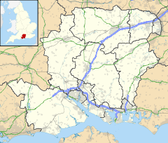
 Cowplain
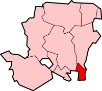
Cowplain shown within HampshirePopulation 8,775 OS grid reference SU695118 Parish Waterlooville District Havant Shire county Hampshire Region South East Country England Sovereign state United Kingdom Post town WATERLOOVILLE Postcode district PO8 Dialling code 023 Police Hampshire Fire Hampshire Ambulance South Central EU Parliament South East England UK Parliament Meon Valley List of places: UK • England • Hampshire Cowplain is a village on the northern outskirts of Waterlooville. With a population of 8775, it takes up 7.3% of Havant borough's population. The origins of the settlement grew along the old London to Portsmouth road (the A3). The village centre and local shops lie on this London Road.
The village boasts several restaurants: Thailand Thai Cuisine (serving Thai food, formerly Sara's, which was previously the Monthai Restaurant which before that was The Indian Cottage restaurant), the O Sole Mio Italian restaurant and takeaway, The National Curry Awards Finalist's; Pasha Bangladeshi Restaurant and the Good View Chinese takeaway. In 2010, a new restaurant, Red Lounge and Grill, was opened by the same people that own Pure Wine Bar and Bistro in Clanfield. There is also a pub, The Spotted Cow, after which the village is reportedly named. There are also shops in the small precinct, including Lidl, Tucker's pharmacy and a small Co-op with a Post Office counter inside. The Co-op store was extensively re-furbished in November 2009 and was re-launched as a Co-op food store.
The village also features a social club, a comprehensive school, Cowplain Community School, and Padnell Infant and Junior Schools, next to a large recreation ground with a park, tennis courts and bowling facilities. There is also Queen's Inclosure Primary School adjacent to the Queen's Inclosure woods, a remnant of the original Forest of Bere. The local church is St. Wilfrid's, although there are a number of others in the area.
The nearest town is Waterlooville and the nearest villages Lovedean and Horndean. The large housing estate, Wecock, lies west of Cowplain.
There are a number of buses that go through Cowplain. The 37 (Stagecoach), from Havant to Clanfield, Petersfield and Liss and the National Express 030 to London. First Provincial services 41, 42 and X41 also go through Cowplain - The 41 route follows the A3 from Clanfield to Gunwharf Quays in Portsmouth; the X41 is the equivalent express service, using the M275 motorway into and out of the city and runs twice a day. There is also the 145 route from Hambledon through Denmead to Cowplain Community School on Weekdays.
Mark Wingett, the actor who played police constable Jim Carver in The Bill television series, grew up in Cowplain and attended the Horndean Community School.
References
- Havant Borough Council. "Profiles & statistics by ward: Cowplain". Archived from the original on 2005-11-24. http://web.archive.org/web/20051124193817/http://www.havant.gov.uk/havant-2306. Retrieved 2006-02-28.
External links
Towns and villages in the Borough of Havant, Hampshire, England 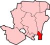 Barncroft • Battins • Bedhampton • Bondfields • Cowplain • Emsworth • Fleet • Hart Plain • Havant • Langstone • Leigh Park • New Brighton • North Hayling • Northney • Purbrook • Purbrook Heath • South Hayling • Skates• Stoke • Tye • Warblington • Warren Park • Waterlooville • Wecock • West Town
Havant Borough Categories:- Villages in Hampshire
- Havant (borough)

Wikimedia Foundation. 2010.