- Oberpframmern
-
Oberpframmern 
 OberpframmernLocation of Oberpframmern within Ebersberg district
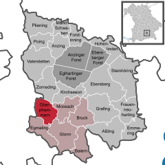
Coordinates 48°1′N 11°49′E / 48.01667°N 11.81667°ECoordinates: 48°1′N 11°49′E / 48.01667°N 11.81667°E Administration Country Germany State Bavaria Admin. region Upper Bavaria District Ebersberg Municipal assoc. Glonn Mayor Theo Rottmayer (Einheitsvorschlag/ Freie Wgem.) Basic statistics Area 18.47 km2 (7.13 sq mi) Elevation 614 m (2015 ft) Population 2,188 (31 December 2010)[1] - Density 118 /km2 (307 /sq mi) Other information Time zone CET/CEST (UTC+1/+2) Licence plate EBE Postal code 85667 Area code 08093 Website www.oberpframmern.de  Pfarrkirche St. Andreas
Oberpframmern is a community in the Upper Bavarian district of Ebersberg and a member of the Verwaltungsgemeinschaft (administrative community) of Glonn. It lies roughly 24 kilometres southeast of Munich.
Contents
Geography
Oberpframmern lies in the Munich Region. It has only one traditional rural land unit (Gemarkung in German), also called Oberpframmern.
History
Oberpframmern belonged to the Rentamt of Munich and the Court of Swabia of the Electorate of Bavaria. It was also seat of a Hauptmannschaft.
Population development
In 1970, the community’s land area was home to 1,179 inhabitants. In 1987 there were 1,522, and in 2000 there were 2,011.
Politics
The mayor (Bürgermeister) is Theo Rottmayer (Einheitsvorschlag/Freie Wgem.).
The community’s tax revenue in 1999, converted into euros, was €1,622,000 of which €605,000 was business taxes.
Economy and infrastructure
According to official statistics, in 1998, 20 workers on the social insurance contribution rolls were employed in agriculture and forestry. In industry it was 118 and in trade and transport 81. In other fields, 122 contributors were employed. Those working from home numbered 682. In processing industries there was one business, and in contracting three. Furthermore, in 1999 there were 25 businesses in agriculture with an area of 506 ha, of which 373 ha was meadowland.
Education
In 1999 the following institutions existed in Oberpframmern:
- Kindergarten: 100 kindergarten places with 90 children
- Elementary school: 1 with 12 teachers and 220 pupils
References
- ^ "Fortschreibung des Bevölkerungsstandes" (in German). Bayerisches Landesamt für Statistik und Datenverarbeitung. 31 December 2010. https://www.statistikdaten.bayern.de/genesis/online?language=de&sequenz=tabelleErgebnis&selectionname=12411-009r&sachmerkmal=QUASTI&sachschluessel=SQUART04&startjahr=2010&endjahr=2010.
External links
- This article incorporates information from the German Wikipedia.
Anzing | Aßling | Baiern | Bruck | Ebersberg | Egmating | Emmering | Forstinning | Frauenneuharting | Glonn | Grafing | Hohenlinden | Kirchseeon | Markt Schwaben | Moosach | Oberpframmern | Pliening | Poing | Steinhöring | Vaterstetten | ZornedingCategories:- Municipalities in Bavaria
- Ebersberg district


Wikimedia Foundation. 2010.