- Mantle (geology)
-
For other uses, see Mantle (disambiguation).
The mantle is a part of a terrestrial planet or other rocky body large enough to have differentiation by density. The interior of the Earth, similar to the other terrestrial planets, is chemically divided into layers. The mantle is a highly viscous layer between the crust and the outer core. Earth's mantle is a rocky shell about 2,890 km (1,800 mi) thick[1] that constitutes about 84 percent of Earth's volume.[2] It is predominantly solid and encloses the iron-rich hot core, which occupies about 15 percent of Earth's volume.[2][3] Past episodes of melting and volcanism at the shallower levels of the mantle have produced a thin crust of crystallized melt products near the surface, upon which we live.[4] The gases evolved during the melting of Earth's mantle have a large effect on the composition and abundance of Earth's atmosphere.[citation needed] Information about structure and composition of the mantle either result from geophysical investigation or from direct geoscientific analyses on Earth mantle derived xenoliths.
Two main zones are distinguished in the upper mantle: the inner asthenosphere composed of flowing rock in the state of plasticity, about 200 km thick,[5] and the lowermost part of the lithosphere, composed of rigid rock, about 50 to 120 km thick.[6] A thin crust, the upper part of the lithosphere, surrounds the mantle and is about 5 to 75 km thick.[7]
Contents
Structure
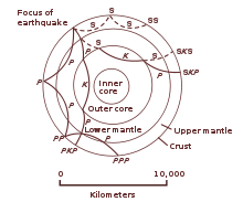
The mantle is divided into sections which are based upon results from seismology. These layers (and their depths) are the following: the upper mantle (starting at the Moho, or base of the crust around 7 to 35 km, downward to 410 km),[8] the transition zone (410–660 km), the lower mantle (660–2891 km), and in the bottom of the latter region there is the anomalous D" layer with a variable thickness (on average ~200 km thick).[4][9][10][11]
The top of the mantle is defined by a sudden increase in seismic velocity, which was first noted by Andrija Mohorovičić in 1909; this boundary is now referred to as the "Mohorovičić discontinuity" or "Moho".[9][12] The uppermost mantle plus overlying crust are relatively rigid and form the lithosphere, an irregular layer with a maximum thickness of perhaps 200 km. Below the lithosphere the upper mantle becomes notably more plastic in its rheology. In some regions below the lithosphere, the seismic velocity is reduced; this so-called low-velocity zone (LVZ) extends down to a depth of several hundred km. Inge Lehmann discovered a seismic discontinuity at about 220 km depth;[13] although this discontinuity has been found in other studies, it is not known whether the discontinuity is ubiquitous. The transition zone is an area of great complexity; it physically separates the upper and lower mantle.[11] Very little is known about the lower mantle apart from that it appears to be relatively seismically homogeneous. The D" layer at the core–mantle boundary separates the mantle from the core.[4][9]
Characteristics
The mantle differs substantially from the crust in its mechanical properties which is the direct consequence of chemical composition change (expressed as different mineralogy). The distinction between crust and mantle is based on chemistry, rock types, rheology and seismic characteristics. The crust is a solidification product of mantle derived melts, expressed as various degrees of partial melting products during geologic time. Partial melting of mantle material is believed to cause incompatible elements to separate from the mantle, with less dense material floating upward through pore spaces, cracks, or fissures, that would subsequently cool and freeze at the surface. Typical mantle rocks have a higher magnesium to iron ratio, and a smaller proportion of silicon and aluminium than the crust. This behavior is also predicted by experiments that partly melt rocks thought to be representative of Earth's mantle.
Mantle rocks shallower than about 410 km depth consist mostly of olivine, pyroxenes, spinel-structure minerals, and garnet;[11] typical rock types are thought to be peridotite,[11] dunite (olivine-rich peridotite), and eclogite. Between about 400 km and 650 km depth, olivine is not stable and is replaced by high pressure polymorphs with approximately the same composition: one polymorph is wadsleyite (also called beta-spinel type), and the other is ringwoodite (a mineral with the gamma-spinel structure). Below about 650 km, all of the minerals of the upper mantle begin to become unstable. The most abundant minerals present have structures (but not compositions) like that of the mineral perovskite followed by the magnesium/iron oxide ferropericlase.[14] The changes in mineralogy at about 400 and 650 km yield distinctive signatures in seismic records of the Earth's interior, and like the moho, are readily detected using seismic waves. These changes in mineralogy may influence mantle convection, as they result in density changes and they may absorb or release latent heat as well as depress or elevate the depth of the polymorphic phase transitions for regions of different temperatures. The changes in mineralogy with depth have been investigated by laboratory experiments that duplicate high mantle pressures, such as those using the diamond anvil.[15]
Composition of Earth's mantle in weight percent[16][citation needed] Element Amount Compound Amount O 44.8 Si 21.5 SiO2 46 Mg 22.8 MgO 37.8 Fe 5.8 FeO 7.5 Al 2.2 Al2O3 4.2 Ca 2.3 CaO 3.2 Na 0.3 Na2O 0.4 K 0.03 K2O 0.04 Sum 99.7 Sum 99.1 The inner core is solid, the outer core is liquid, and the mantle solid/plastic. This is because of the relative melting points of the different layers (nickel-iron core, silicate crust and mantle) and the increase in temperature and pressure as one moves deeper into the Earth. At the surface both nickel-iron alloys and silicates are sufficiently cool to be solid. In the upper mantle, the silicates are generally solid (localised regions with small amounts of melt exist); however, as the upper mantle is both hot and under relatively little pressure, the rock in the upper mantle has a relatively low viscosity, i.e. it is relatively fluid. In contrast, the lower mantle is under tremendous pressure and therefore has a higher viscosity than the upper mantle. The metallic nickel-iron outer core is liquid despite the enormous pressure as it has a melting point that is lower than the mantle silicates. The inner core is solid due to the overwhelming pressure found at the center of the planet.[17]
Temperature
In the mantle, temperatures range between 500 to 900 °C (932 to 1,652 °F) at the upper boundary with the crust; to over 4,000 °C (7,230 °F) at the boundary with the core.[17] Although the higher temperatures far exceed the melting points of the mantle rocks at the surface (about 1200 °C for representative peridotite), the mantle is almost exclusively solid.[17] The enormous lithostatic pressure exerted on the mantle prevents melting, because the temperature at which melting begins (the solidus) increases with pressure.
Movement
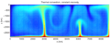 This figure is a snapshot of one time-step in a model of mantle convection. Colors closer to red are hot areas and colors closer to blue are cold areas. In this figure, heat received at the core-mantle boundary results in thermal expansion of the material at the bottom of the model, reducing its density and causing it to send plumes of hot material upwards. Likewise, cooling of material at the surface results in its sinking.
Due to the temperature difference between the Earth's surface and outer core, and the ability of the crystalline rocks at high pressure and temperature to undergo slow, creeping, viscous-like deformation over millions of years, there is a convective material circulation in the mantle.[9] Hot material upwells, while cooler (and heavier) material sinks downward. Downward motion of material occurs at convergent plate boundaries called subduction zones. Locations on the surface that lie over plumes are predicted to have high elevation (due to the buoyancy of the hotter, less-dense plume beneath) and to exhibit hot spot volcanism. The volcanism often attributed to deep mantle plumes is alternatively explained by passive extension of the crust, permitting magma to leak to the surface (the "Plate" hypothesis).[18]
The convection of the Earth's mantle is a chaotic process (in the sense of fluid dynamics), which is thought to be an integral part of the motion of plates. Plate motion should not be confused with the older term continental drift which applies purely to the movement of the crustal components of the continents. The movements of the lithosphere and the underlying mantle are coupled since descending lithosphere is an essential component of convection in the mantle. The observed continental drift is a complicated relationship between the forces causing oceanic lithosphere to sink and the movements within Earth's mantle.
Although there is a tendency to larger viscosity at greater depth, this relation is far from linear, and shows layers with dramatically decreased viscosity, in particular in the upper mantle and at the boundary with the core.[19] The mantle within about 200 km above the core-mantle boundary appears to have distinctly different seismic properties than the mantle at slightly shallower depths; this unusual mantle region just above the core is called D″ ("D double-prime"), a nomenclature introduced over 50 years ago by the geophysicist Keith Bullen.[20] D″ may consist of material from subducted slabs that descended and came to rest at the core-mantle boundary and/or from a new mineral polymorph discovered in perovskite called post-perovskite.
Earthquakes at shallow depths are a result of stick-slip faulting, however, below about 50 km the hot, high pressure conditions ought to inhibit further seismicity. The mantle is also considered to be viscous, and so incapable of brittle faulting. However, in subduction zones, earthquakes are observed down to 670 km. A number of mechanisms have been proposed to explain this phenomenon, including dehydration, thermal runaway, and phase change.
The geothermal gradient can be lowered where cool material from the surface sinks downward, increasing the strength of the surrounding mantle, and allowing earthquakes to occur down to a depth of 400 km and 670 km.
The pressure at the bottom of the mantle is ~136 GPa (1.4 million atm).[11] There exists increasing pressure as one travels deeper into the mantle, since the material beneath has to support the weight of all the material above it. The entire mantle, however, is still thought to deform like a fluid on long timescales, with permanent plastic deformation accommodated by the movement of point, line, and/or planar defects through the solid crystals comprising the mantle. Estimates for the viscosity of the upper mantle range between 1019 and 1024 Pa·s, depending on depth,[19] temperature, composition, state of stress, and numerous other factors. Thus, the upper mantle can only flow very slowly. However, when large forces are applied to the uppermost mantle it can become weaker, and this effect is thought to be important in allowing the formation of tectonic plate boundaries.
Exploration
Exploration of the mantle is generally conducted at the seabed rather than on land due to the relative thinness of the oceanic crust as compared to the significantly thicker continental crust.
The first attempt at mantle exploration, known as Project Mohole, was abandoned in 1966 after repeated failures and cost over-runs. The deepest penetration was approximately 180 m (590 ft). In 2005 the third-deepest oceanic borehole reached 1,416 metres (4,646 ft) below the sea floor from the ocean drilling vessel JOIDES Resolution.
On 5 March 2007, a team of scientists on board the RRS James Cook embarked on a voyage to an area of the Atlantic seafloor where the mantle lies exposed without any crust covering, mid-way between the Cape Verde Islands and the Caribbean Sea. The exposed site lies approximately three kilometres beneath the ocean surface and covers thousands of square kilometres.[21][22]
A relatively difficult attempt to retrieve samples from the Earth's mantle was scheduled for later in 2007.[23] As part of the Chikyu Hakken mission, was to use the Japanese vessel 'Chikyu' to drill up to 7,000 m (23,000 ft) below the seabed. This is nearly three times as deep as preceding oceanic drillings.
A novel method of exploring the uppermost few hundred kilometres of the Earth was recently proposed, consisting of a small, dense, heat-generating probe which melts its way down through the crust and mantle while its position and progress are tracked by acoustic signals generated in the rocks.[24] The probe consists of an outer sphere of tungsten about one metre in diameter inside which is a cobalt-60 radioactive heat source. It was calculated that such a probe will reach the oceanic Moho in less than 6 months and attain minimum depths of well over 100 km in a few decades beneath both oceanic and continental lithosphere.[25]
Exploration can also be aided through computer simulations of the evolution of the mantle. In 2009, a supercomputer application provided new insight into the distribution of mineral deposits, especially isotopes of iron, from when the mantle developed 4.5 billion years ago.[26]
See also
- Core–mantle boundary
- Mohorovičić discontinuity
- Lehmann discontinuity
- Post-perovskite phase transition
- Mantle convection
- Mesosphere (mantle)
- Mantle xenoliths
Shells Discontinuities Arguments References
- ^ Mantle: Schlumberger Oilfield Glossary
- ^ a b Robertson, Eugene (2007). "The interior of the earth". USGS. http://pubs.usgs.gov/gip/interior/. Retrieved 2009-01-06.
- ^ Core: Schlumberger Oilfield Glossary
- ^ a b c "The structure of the Earth". Moorland School. 2005. http://www.moorlandschool.co.uk/earth/earths_structure.htm. Retrieved 2007-12-26.
- ^ Asthenosphere: Schlumberger Oilfield Glossary .
- ^ Lithosphere: Schlumberger Oilfield Glossary
- ^ Crust: Schlumberger Oilfield Glossary
- ^ The location of the base of the crust varies from approximately 10 to 70 kilometers. Oceanic crust is generally less than 10 kilometers thick. "Standard" continental crust is around 35 kilometers thick, and the large crustal root under the Tibetan Plateau is approximately 70 kilometers thick.
- ^ a b c d Alden, Andrew (2007). "Today's Mantle: a guided tour". About.com. http://geology.about.com/library/weekly/aa031598.htm. Retrieved 2007-12-25.
- ^ Earth cutaway (image). Retrieved 2007-12-25.
- ^ a b c d e Burns, Roger George (1993). Mineralogical Applications of Crystal Field Theory. Cambridge University Press. p. 354. ISBN 0521430771. http://books.google.com/books?id=JiTuaX_1TU0C&pg=PA354&lpg=PA354&dq=mantle+chemical+composition&source=web&ots=szv6r4wlPA&sig=zRN1iHTek4r4pXxeTYLS2JOGazs. Retrieved 2007-12-26.
- ^ "Istria on the Internet – Prominent Istrians – Andrija Mohorovicic". 2007. http://istrianet.org/istria/illustri/mohorovicic/. Retrieved 2007-12-25.
- ^ Carlowicz, Michael (2005). "Inge Lehmann biography". American Geophysical Union, Washington, D.C.. Archived from the original on 2007-09-30. http://web.archive.org/web/20070930153806/http://www.agu.org/inside/awards/lehmann2.html. Retrieved 2007-12-25.
- ^ Anderson, Don L. (2007) New Theory of the Earth. Cambridge University Press. ISBN 978-0-521-84959-3, 0-521-84959-4
- ^ Alden, Andrew. "The Big Squeeze: Into the Mantle". About.com. http://geology.about.com/library/weekly/aa030898.htm. Retrieved 2007-12-25.
- ^ mantle@Everything2.com. Retrieved 2007-12-26.
- ^ a b c Louie, J. (1996). "Earth's Interior". University of Nevada, Reno. http://crack.seismo.unr.edu/ftp/pub/louie/class/100/interior.html. Retrieved 2007-12-24.
- ^ Foulger, G.R. (2010). Plates vs. Plumes: A Geological Controversy. Wiley-Blackwell. ISBN 978-1-4051-6148-0. http://www.wiley.com/WileyCDA/WileyTitle/productCd-1405161485.html.
- ^ a b Mantle Viscosity and the Thickness of the Convective Downwellings retrieved on November 7, 2007
- ^ Alden, Andrew. "The End of D-Double-Prime Time?". About.com. http://geology.about.com/library/weekly/aa021300a.htm. Retrieved 2007-12-25.
- ^ Than, Ker (2007-03-01). "Scientists to study gash on Atlantic seafloor". Msnbc.com. http://www.msnbc.msn.com/id/17407745/. Retrieved 2008-03-16. "A team of scientists will embark on a voyage next week to study an “open wound” on the Atlantic seafloor where the Earth’s deep interior lies exposed without any crust covering."
- ^ "Earth's Crust Missing In Mid-Atlantic". Science Daily. 2007-03-02. http://www.sciencedaily.com/releases/2007/03/070301103112.htm. Retrieved 2008-03-16. "Cardiff University scientists will shortly set sail (March 5) to investigate a startling discovery in the depths of the Atlantic."
- ^ "Japan hopes to predict 'Big One' with journey to center of Earth". PhysOrg.com. 2005-12-15. Archived from the original on 2005-12-19. http://web.archive.org/web/20051219103451/http://www.physorg.com/news9073.html. Retrieved 2008-03-16. "An ambitious Japanese-led project to dig deeper into the Earth's surface than ever before will be a breakthrough in detecting earthquakes including Tokyo's dreaded "Big One," officials said Thursday."
- ^ Ojovan M.I., Gibb F.G.F., Poluektov P.P., Emets E.P. 2005. Probing of the interior layers of the Earth with self-sinking capsules. Atomic Energy, 99, 556–562
- ^ Ojovan M.I., Gibb F.G.F. "Exploring the Earth’s Crust and Mantle Using Self-Descending, Radiation-Heated, Probes and Acoustic Emission Monitoring". Chapter 7. In: Nuclear Waste Research: Siting, Technology and Treatment, ISBN 978-1-60456-184-5, Editor: Arnold P. Lattefer, Nova Science Publishers, Inc. 2008
- ^ University of California - Davis (2009-06-15). Super-computer Provides First Glimpse Of Earth's Early Magma Interior. ScienceDaily. Retrieved on 2009-06-16 from http://www.sciencedaily.com/releases/2009/06/090615153118.htm.
Further reading
- Don L. Anderson, Theory of the Earth, Blackwell (1989), is a textbook dealing with the Earth's interior and is now available on the web. Retrieved 2007-12-23.
- Jeanloz, Raymond (2000). "Mantle of the Earth". In Haraldur Sigurdsson, Bruce Houghton, Hazel Rymer, John Stix, Steve McNutt. Encyclopedia of Volcanoes. San Diego: Academic Press. pp. 41–54. ISBN 978-0126431407. http://www.amazon.com/Encyclopedia-Volcanoes-Bruce-Houghton/dp/012643140X#noop. Retrieved 2010-05-17.
- Nixon, Peter H. (1987). Mantle xenoliths: J. Wiley & Sons, 844p., (ISBN 0-471-91209-3).
External links
- The Biggest Dig: Japan builds a ship to drill to the earth's mantle – Scientific American Magazine (September 2005)
- Information on the Mohole Project
- Thinkquest Team (2000). "The Mantle". http://mediatheek.thinkquest.nl/~ll125/en/mantle.htm. Retrieved 2007-12-25.
Shells Discontinuities Arguments Categories:


Wikimedia Foundation. 2010.