- Los Gatos, California
Infobox Settlement
official_name = Town of Los Gatos, California
other_name =
native_name =
nickname =
settlement_type =Town
motto =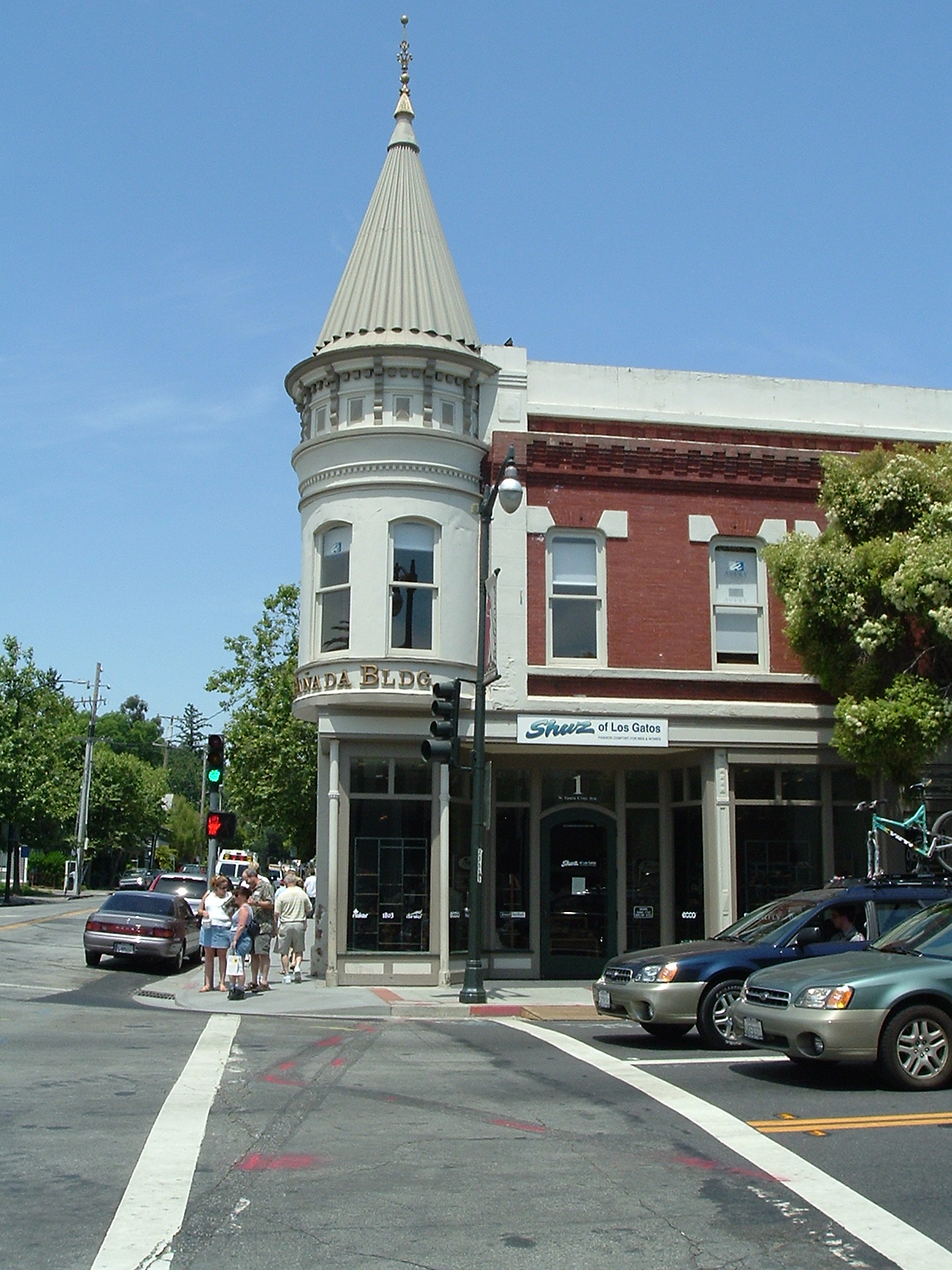
imagesize =
image_caption =
flag_size =
image_
seal_size =
image_shield =
shield_size =
image_blank_emblem =
blank_emblem_type =
blank_emblem_size =
flag_size =
image_
seal_size =
image_shield =
shield_size =
image_blank_emblem =
blank_emblem_type =
blank_emblem_size =
mapsize = 250x200px
map_caption = Location in Santa Clara County and the state ofCalifornia
mapsize1 =
map_caption1 =
image_dot_
dot_mapsize =
dot_map_caption =
dot_x =
dot_y =
pushpin_
pushpin_label_position =
pushpin_map_caption =
pushpin_mapsize =
subdivision_type = Country
subdivision_name =United States
subdivision_type1 = State
subdivision_name1 =California
subdivision_type2 = County
subdivision_name2 = Santa Clara
subdivision_type3 =
subdivision_name3 =
subdivision_type4 =
subdivision_name4 =
government_footnotes =
government_type =
leader_title =Mayor
leader_name = Barbara Spector
leader_title1 =
leader_name1 =
leader_title2 =
leader_name2 =
leader_title3 =
leader_name3 =
leader_title4 =
leader_name4 =
established_title =
established_date =
established_title2 =
established_date2 =
established_title3 =
established_date3 =
area_magnitude = 1 E8
unit_pref =
area_footnotes =
area_total_km2 = 28.0
area_land_km2 = 27.7
area_water_km2 = 0.3
area_total_sq_mi = 10.8
area_land_sq_mi = 10.7
area_water_sq_mi = 0.1
area_water_percent =
area_urban_km2 =
area_urban_sq_mi =
area_metro_km2 =
area_metro_sq_mi =
area_blank1_title =
area_blank1_km2 =
area_blank1_sq_mi =
population_as_of = 2000
population_footnotes =
population_note =
population_total = 28592
population_density_km2 = 1030.8
population_density_sq_mi = 2669.1
population_metro =
population_density_metro_km2 =
population_density_metro_sq_mi =
population_urban =
population_density_urban_km2 =
population_density_urban_sq_mi =
population_blank1_title =
population_blank1 =
population_density_blank1_km2 =
population_density_blank1_sq_mi =
timezone = PST
utc_offset = -8
timezone_DST = PDT
utc_offset_DST = -7
latd = 37 |latm = 14 |lats = 10 |latNS = N
longd = 121 |longm = 57 |longs = 42 |longEW = W
elevation_footnotes =
elevation_m = 105
elevation_ft = 344
postal_code_type =ZIP code s
postal_code = 95030-95032
area_code = 408
blank_name = FIPS code
blank_info = 06-44112
blank1_name = GNIS feature ID
blank1_info = 1659017
website = http://www.losgatosca.gov/
footnotes =Los Gatos is an incorporated town in Santa Clara County,
California ,United States . The population was 28,592 at the 2000 census. It is located in theSan Francisco Bay Area , on the edge ofSilicon Valley on the southwest corner of San Jose in the foothills of theSanta Cruz Mountains . Homes are mostly upscale, varying from one million-dollarcottage s in the village itself to 7- or 8-million-dollar large custom homes in the surrounding hills. The town is noted for its small but upscale downtown, with many chic shops and restaurants. It is also a preferred destination forantique shopping.The name "Los Gatos" is Spanish, meaning "the cats". The name derives from the 1839
Alta California land-grant that encompassed the area, which was called "Rancho Rinconada de Los Gatos ", ("the corner of the cats"), where "the cats" refers to the wild cats (bobcats andmountain lion s) that are indigenous to theSanta Cruz Mountains in whose foothills the town is nestled. The name is normally pronounced in anglicized form, sounding like "las gaddis" (IPA2|lɑsˈgæɾɪs), although one also hears pronunciations truer to the original Spanish, "lohs GAH tos" (IPAEng|loʊsˈgɑːtoʊs).History
Overview
The founding of the town dates to the mid-1850s with the building of
Forbes Mill by James Alexander Forbes along Los Gatos Creek. The townsite that was established in the 1860s was originally named for the mill, but the name was changed to Los Gatos after the Spanish land grant. The town was incorporated in 1887 and remained an important town for the logging industry in the Santa Cruz Mountains through the end of the 19th century. In the early 20th century the town became a thriving agricultural town withapricot s,grape s and prunes being grown in the area. Along with much of theSanta Clara Valley , Los Gatos became a suburban community for San Jose beginning in the 1950s, and the town was mostly built-out by the 1980s.Downtown Los Gatos has retained and restored many of its Victorian-era homes and commercial buildings. Other notable buildings are the
Forbes Mill annex, dating to 1880 and now housing a history museum,Los Gatos High School which dates from the 1920s, and the Old Town Shopping Center, formerly the University Avenue School (the school was established in 1882; the current buildings date to 1923).Downtown Los Gatos was heavily damaged in the
1989 Loma Prieta earthquake .Rail transportation
Transport by rail was an early feature of Los Gatos. The South Pacific Coast
railroad , a popularnarrow-gauge line from Alameda (and San Francisco via ferry) to Santa Cruz in the late 19th century, stopped in Los Gatos. [http://www.spcrr.org/HistorySPCRR.htm] Southern Pacific took over this line in 1887. Los Gatos was also near the Southern Pacific resort town of Holy City, along the rail line in theSanta Cruz Mountains . The last Southern Pacific passenger train to Santa Cruz left Los Gatos in March 1940. In town, the rail line used to run along the shore ofVasona Reservoir to the present-day location of the Post Office, following the path of what is now a continuous string of parking lots between Santa Cruz Ave. and University Ave. There was also a streetcar-type rail line with service to Saratoga and San Jose. Streetcar service via thePeninsular Railway started about 1905 and ended about 1933. San Francisco commuter trains continued into downtown until 1959, and Vasona Junction until 1962. The site of the old railroad station is now occupied by Town Plaza and the Post Office.Geography and environment
Los Gatos is located at coor dms|37|14|10|N|121|57|42|W|city (37.236044, -121.961768)GR|1. Los Gatos is bisected by State Route 17, which runs through the town from south to north. The terms "East Los Gatos" and "West Los Gatos" are sometimes used to describe the parts of the town that lie east and west of Highway 17, respectively, but there is no official governmental division of the town as such. Prior to 1997, the town's two main
ZIP code s corresponded to the portions of the town east and west of Highway 17, with 95032 on the east side and 95030 on the west side, but the postal service rezoned the ZIP codes along a north-south division, to better correspond to the two post offices in Los Gatos, which are located at the north and south ends of town.State Route 85 roughly marks the northern boundary of the town, although a few pockets of homes to its North are included. Highway 9 (Los Gatos-Saratoga Road) from the coast terminates at Highway 17. Downtown Los Gatos, the area on and around Santa Cruz Avenue and Main Street, is located in the southwest quadrant of town. A left exit on northbound Highway 17 becomes the south end of South Santa Cruz Avenue, leading into downtown. The area around Los Gatos Boulevard, east of Highway 17, is much more typically suburban than downtown, with medium-sized shopping centers clustered at major intersections of the multilane boulevard. Although the town has generally a quiet setting, its principal noise generators are State Route 17 and Los Gatos Boulevard. Sound levels within one hundred and fifty feet of Los Gatos Boulevard exceed 60 CNEL (Community Noise Equivalent Level), ["Environmental Impact Report for the Superlife Care Facility", Earth Metrics Incorporated, prepared for the city of Los Gatos, California and the State of California Environmental Clearinghouse, March, 1989] a generally unacceptable range for residential living.
Vasona Park , a county park, and neighboring Oak Meadow Park, which belongs to the town, are located in what is roughly the geographic middle of the town, bordered on the south by Blossom Hill Road, on the east by Highway 17, on the west by University Avenue, and reaching at the north end not quite all the way to Lark Avenue. Located in the parks is the popularBilly Jones Wildcat Railroad. In Vasona Park is the trail toPrune Ridge . Los Gatos Creek begins in the Santa Cruz Mountains south of the town and runs through the town parallel to Highway 17 all the way through neighboring Campbell and San Jose to the Guadalupe River, which flows intoSan Francisco Bay . A walking, jogging, and biking trail called theLos Gatos Creek Trail runs alongside much of the creek from Lexington Dam through Vasona Park and Campbell to Meridian Avenue in San Jose. In Los Gatos, the trail passes the 1854Forbes Mill .According to the
United States Census Bureau , the town has a total area of 28.0 km² (10.8 mi²). 27.7 km² (10.7 mi²) of it is land and 0.3 km² (0.1 mi²) of it (0.93%) is water.Los Gatos is surrounded by several
mountain bike trails. Cyclists can leave from downtown on a convert|20|mi|km|sing=on loop through theSanta Cruz Mountains . Road cycling is also popular. Downtown is often crowded with cyclists on weekend mornings. From downtown, El Sereno mountain stands to the southwest; El Sombroso stands to the southeast.Demographics
As of the
census GR|2 of 2000, there were 28,592 people, 11,988 households, and 7,300 families residing in the town. Thepopulation density was 1,030.8/km² (2,669.1/mi²). There were 12,367 housing units at an average density of 445.8/km² (1,154.5/mi²). The ethnic makeup of the town was 86.68% Caucasian, 0.79% African American, 0.30% Native American, 7.60% Asian, 0.07% Pacific Islander, 1.28% from other races, and 3.27% from two or more races. Hispanic or Latino of any race were 5.21% of the population.There were 11,988 households out of which 27.3% had children under the age of 18 living with them, 50.9% were married couples living together, 7.2% had a female householder with no husband present, and 39.1% were non-families. 29.7% of all households were made up of individuals and 10.0% had someone living alone who was 65 years of age or older. The average household size was 2.33 and the average family size was 2.93.
In the town the population was spread out with 21.2% under the age of 18, 4.3% from 18 to 24, 31.5% from 25 to 44, 27.7% from 45 to 64, and 15.3% who were 65 years of age or older. The median age was 41 years. For every 100 females there were 90.4 males. For every 100 females age 18 and over, there were 87.2 males.
The median income for a household in the town was $94,319, and the median income for a family was $119,194. Males had a median income of $89,420 versus $57,596 for females. The
per capita income for the town was $56,094. About 3.1% of families and 4.3% of the population were below thepoverty line , including 4.4% of those under age 18 and 5.6% of those age 65 or over.Politics
In the state legislature Los Gatos is located in the 15th Senate District, represented by Republican
Abel Maldonado , and in the 21st Assembly District, represented by DemocratIra Ruskin . Federally, Los Gatos is located inCalifornia's 15th congressional district , which has a Cook PVI of D +14 [cite web | title = Will Gerrymandered Districts Stem the Wave of Voter Unrest? | publisher = Campaign Legal Center Blog | url=http://www.clcblog.org/blog_item-85.html | accessdate = 2008-02-10] and is represented by DemocratMike Honda .Major companies headquartered in Los Gatos
*
Artus Clothing
*Cryptic Studios
*IC Manage
*Netflix
* Transitive
*Buongiorno Transportation
The town of Los Gatos is served by the
VTA , (Valley Transit Authority) which also serves the majority of thecounty of Santa Clara , including San Jose, the largest city in theBay Area .The two Los Gatos Community Buses run from Santa Cruz and Main to the Winchester Transit Center, the 49 via Los Gatos Boulevard and the 48 via Winchester.
For railroad transportation the nearby city of Santa Clara has the closest train station served by
Caltrain , and the nearby city of Campbell provides access toVTA light-rail via the Winchester, Downtown Campbell, and Hamilton stations.For Air Travel the closest international airports are
San Jose International Airport (SJC),San Francisco International Airport (SFO),Oakland International Airport . All these airports are used for Air travel by people across the bay area.Notable residents
*
Olivia de Havilland - Actress - Sister ofJoan Fontaine
*Joan Fontaine - Actress - Sister ofOlivia de Havilland
*Mark Bingham andTodd Beamer , passengers ofUnited Airlines Flight 93 on 9/11 believed to have stormed the cockpit after its hijacking
*Trent Edwards -Buffalo Bills starting quarterback
*A. J. Allmendinger - Race car driver
*Kari Byron - Artist and television personality
*Hal Chase - Early 20th century baseball star (born in Los Gatos)
*Gary Dahl - Inventor of thePet Rock
*Peggy Fleming - Olympic Gold Medalistfigure skater
*Tim Hunter - Former NHL forward, assistant coach,San Jose Sharks
*Joe Kapp - Former professional football player
*Patrick Marleau - Captain,San Jose Sharks
*Ryan Nyquist - Professional BMX rider
*Dale B. Phelps - Aerospace Engineer and Musician
*Rudy Rucker - Author
*Josh Shipp - Youth speaker and author
*Scott Stillinger - Inventor of theKoosh Ball
*Matt Swanson - Professional Baseball Player -Pittsburgh Pirates
*Doug Wilson - Manager, San Jose Sharks
*Steve Wozniak -Apple Computer co-founder
*John Steinbeck - Acclaimedauthor , resident for several years
*Jeremy Roenick -San Jose Sharks player
*Jared Allen -NFL player currently with theMinnesota Vikings
*Anglophone (band) - band membersSister cities
Los Gatos has five official sister cities: [cite web | title = Monte Sereno explores sister city relationship | publisher = Los Gatos Weekly Times | url= http://www.svcn.com/archives/lgwt/02.27.02/sistercity-0209.html | accessdate = 2008-08-20]
*)
*
*
*
*Schools
Public schools
*
Lakeside Joint School District
**Lakeside Elementary School [http://www.lakesidelosgatos.org/index.html (website)]
*Loma Prieta Joint Union Elementary School District [http://www.loma.k12.ca.us/District/ (website)]
**C T English Middle School [http://www.loma.k12.ca.us/cte/ (website)]
**Loma Prieta Elementary School [http://www.loma.k12.ca.us/lps/ (website)]
**Loma Prieta Independent Home Study center ::Provides enrichment courses for homeschooled children in grades K-8. [cite web | title = Home Sweet School | publisher = Los Gatos Weekly Times | url=http://www.svcn.com/archives/lgwt/01.09.02/cover-0202.html | accessdate = 2008-08-20]
*Los Gatos-Saratoga Joint Union High School District [http://www.lgsuhsd.org/ (website)]
**Los Gatos High School [http://www.lghs.net/ (website)]
*Los Gatos Union School District [http://www.lgusd.k12.ca.us/ (website)]
**Blossom Hill Elementary School [http://www.bh.lgusd.k12.ca.us/ (website)]
**Daves Avenue Elementary School [http://www.daves.lgusd.k12.ca.us/index.html (website)]
**Lexington Elementary School [http://www.lex.lgusd.k12.ca.us/ (website)]
**(Louise) Van Meter Elementary School [http://www.lvm.lgusd.k12.ca.us/ (website)]
**(Raymond J.) Fisher Middle School [http://www.rjfisher.lgusd.k12.ca.us/ (website)]
* Union School District
**Alta Vista Elementary School Private schools
*Catholic
**St. Mary of the Immaculate Conception Elementary School [http://www.stmaryslg.org (website)]
* Christian
**Los Gatos Christian Junior High School
**Los Gatos Christian School
*Jewish
**Yavneh Day School [http://www.yavnehdayschool.org/ (website)]
*Secular
**Hillbrook School [http://www.hillbrook.org/Default.asp?bhcp=1 (website)]
**Los Gatos Academy
**Mulberry School [http://www.mulberry.org/ (website)]
** Stratford School [http://www.stratfordschools.com/podium/default.aspx?t=104378 (website)]References
External links
* [http://www.town.los-gatos.ca.us/ Town of Los Gatos Official Web Site]
* [http://www.library.losgatosca.gov/ Los Gatos Public Library]
* [http://losgatosobserver.com/ Los Gatos Observer news and information]
* [http://liveinlosgatos.realtownblogs.com/ "Live in Los Gatos" Blog]
* [http://www.LGUSL.org/ Los Gatos United Soccer League Official Web Site]
* [http://www.spcrr.org/HistorySPCRR.htm South Pacific Coast railroad]
* [http://gregvanderlaan.com/los_gatos.aspx Photos of The Famous CAT Sculptures]
* [http://www.losgatoschamber.com Los Gatos Chamber of Commerce]
Wikimedia Foundation. 2010.