- Meols
-
Coordinates: 53°24′05″N 3°09′19″W / 53.4014°N 3.1553°W
Meols 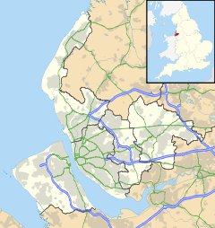
 Meols
Meols
Meols shown within MerseysidePopulation 5,110 (2001 Census)[1] OS grid reference SJ232900 Metropolitan borough Metropolitan Borough of Wirral Metropolitan county Merseyside Region North West Country England Sovereign state United Kingdom Post town WIRRAL Postcode district CH47, CH48 Dialling code 0151 Police Merseyside Fire Merseyside Ambulance North West EU Parliament North West England UK Parliament Wirral West List of places: UK • England • Merseyside -
- This article is about the village on the Wirral Peninsula. See also Meols Cop for the Southport suburb.
Meols (
 /ˈmɛlz/) is a village on the northern coast of the Wirral Peninsula, England. It is contiguous with the larger town of Hoylake, situated immediately to the west. Formerly, Meols was in the county of Cheshire, although since 1 April 1974 it has been a part of the Metropolitan Borough of Wirral in the metropolitan county of Merseyside. The 2001 Census recorded the population of Meols as 5,110 (2,380 males, 2,730 females).[1]
Contents
History
Meols was named as such by the Vikings; its original name from the Old Norse for 'sand dunes' was melr,[2][3] becoming melas by the time of the Domesday Survey.[4]
Impressive archaeological finds dating back to the Neolithic period suggest that the site was an important centre in antiquity. Since about 1810, a large number of artefacts have been found relating to pre-Roman Carthage, the Iron Age, the Roman Empire, the Anglo-Saxons and the Vikings. These include items as varied as coins, tokens, brooches, pins, knives, glass beads, keys, pottery, flint tools, mounts, pilgrim badges, pieces of leather, worked wood and iron tools. They came to be discovered after the beginning of large-scale dredging (to accommodate the needs of the nearby growing seaport of Liverpool) started to cause notable sand erosion along the coastline near Meols. These finds suggest that the site was used as a port as far back as the Iron Age some 2400 years ago, and was once the most important seaport in the present-day northwest of England. Thus trading connections are believed to have reached far across Europe.[5] [6]
Many of the present day inhabitants of Meols show Viking ancestry. In 2002, University of Nottingham researchers began investigating the degree of Viking blood still extant in the village.[7]
Meols is an amalgam of the two former villages of Great Meols and Little Meols. Both were townships in West Kirby Parish of the Wirral Hundred, becoming part of Hoylake cum West Kirby civil parish in 1894. Great Meols had a population of 140 in 1801, 170 in 1851 and 821 in 1901.[8] The name Little Meols fell out of use in Victorian times, having been absorbed by Hoylake. From 123 inhabitants in 1801 and 170 in 1851, by 1901 at 2,850, its population had outstripped Great Meols.[9] The name Great Meols was still in use up to the 1960s, for instance in postal addresses and on the destination indicators of buses from Chester, but not as the name of the railway station. Little Meols was situated to the west (towards Hoylake), in the area served by Manor Road railway station.
Meols was known to be spelt as Meolse[10] up until when the railway station was placed.[citation needed] The error came about at the time of the station's construction, when rail managers took the spelling of Meols from the Southport suburb of Meols Cop and used it for new signage.[citation needed]
Description
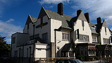 The Railway Inn has an undated boat buried under its car park
Meols is mainly residential with a small yacht and fishing community on its Irish Sea shore line. The centre has a small row of shops adjacent to Meols railway station. There is a local community park known as Meols Park Recreation Ground and a Meols bowling green. The Friends of Meols Park are a community group set up in 2007 to help maintain and improve the Recreation Ground.
It was home to the cyclist Chris Boardman, winner of a gold medal for Great Britain at the 1992 Summer Olympics, before he moved to Hoylake.
In the 1930s a clinker-built boat was discovered in rebuilding the Railway Inn public house. Ground-penetrating radar equipment was used in September 2007 to confirm the existence of the boat. The vessel is believed to be lying beneath approximately 6 ft to 10 ft (2m to 3m) of clay.[11] Professor Stephen Harding, of the University of Nottingham, is seeking funds for an excavation and removal to a museum.
Cultural references
Andy McCluskey of the 1980s electronic music band Orchestral Manoeuvres in the Dark (OMD) is from Meols. OMD had a track called Red Frame/White Light which referred to the public telephone box between the church and the Railway Inn in Meols. Hidden within the lyrics was the telephone number of the telephone box (6323003). It is claimed that fans would call that telephone number from all over the world.
The television sitcom Watching, produced by Granada Television between 1987 and 1993, utilised Meols as a filming location. This was likely because the characters Malcolm & Mrs Stoneway lived in the village.[12]
Members of the highly acclaimed rock band The Coral were also residents of Meols, not Liverpool as usually referenced. http://www.thecoral.co.uk/
Transport
Rail
Station Operator Route Days of Operation Meols Merseyrail Wirral Line (West Kirby-Liverpool Central) Monday-Sunday Bus
Number Route Operator Days of Operation 38 West Kirby-New Ferry First Chester & The Wirral Monday-Saturday 83/83A West Kirby-Birkenhead Avon Buses Monday-Friday 138 Newton-Meols A1A Travel Monday-Saturday 186 Eastham Ferry-Leasowe Avon Buses Evenings and Sundays References
- ^ a b "wirral 2001 Census: Meols". Metropolitan Borough of Wirral. Archived from the original on 16 June 2008. http://web.archive.org/web/20080616062700/http://www.wirral.gov.uk/factsandfigures/census2001/oneward2recset.asp?ref=TS23. Retrieved 17 September 2007.
- ^ "Field Archaeology: Meols, Medieval & after". National Museums Liverpool. http://www.liverpoolmuseums.org.uk/mol/archaeology/fieldarchaeology/meols2.asp. Retrieved 17 September 2007.
- ^ "Wirral & West Lancs 1100th Viking Anniversary". Nottingham University. http://www.nottingham.ac.uk/-sczsteve/. Retrieved 17 September 2007.
- ^ "Cheshire (L-Z)". Domesday Book Online. http://www.domesdaybook.co.uk/cheshire2.html. Retrieved 17 September 2007.
- ^ "Field Archaeology: Meols, An ancient port". National Museums Liverpool. http://www.liverpoolmuseums.org.uk/mol/archaeology/fieldarchaeology/meols.asp. Retrieved 1 January 2008.
- ^ "Great Sites: Meols". British Archaeology magazine. December 2001. http://www.britarch.ac.uk/ba/ba62/feat3.shtml. Retrieved 1 January 2008.
- ^ "Genetic Survey of Wirral and West Lancashire". Nottingham University. http://www.nottingham.ac.uk/~sczsteve/survey.htm. Retrieved 27 January 2008.
- ^ "Cheshire Parishes: Great Meols". GENUKI UK & Ireland Genealogy. http://www.ukbmd.org.uk/genuki/chs/greatmeols.html. Retrieved 17 September 2007.
- ^ "Cheshire Parishes: Little Meols". GENUKI UK & Ireland Genealogy. http://www.ukbmd.org.uk/genuki/chs/littlemeols.html. Retrieved 17 September 2007.
- ^ "Little Meols". A Vision of Britain Through Time. http://www.visionofbritain.org.uk/unit_page.jsp?u_id=10007940. Retrieved 17 September 2007.
- ^ "Has a Viking boat really been discovered in Meols?". National Museums Liverpool. http://www.liverpoolmuseums.org.uk/mol/archaeology/fieldarchaeology/meols_viking_boat.asp. Retrieved 20 March 2008.
- ^ "Watching". http://www.cmsinet.demon.co.uk/watching-tv.net/homepage.htm. Retrieved 20 March 2008.
External links
Categories:- Towns and villages in Wirral (borough)
- Viking Age populated places
-


Wikimedia Foundation. 2010.